|
|
Post by 1dave on Oct 11, 2020 14:39:58 GMT -7
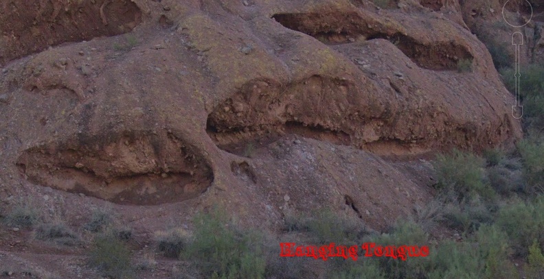
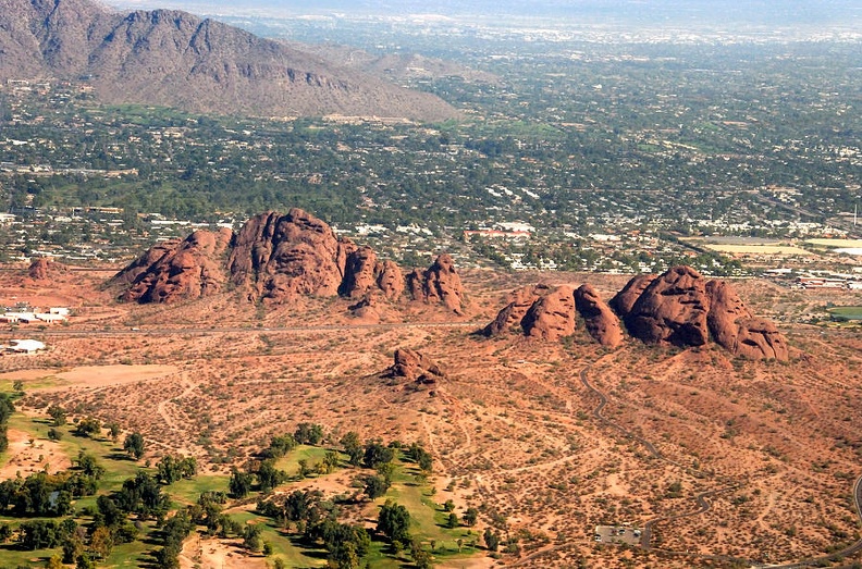
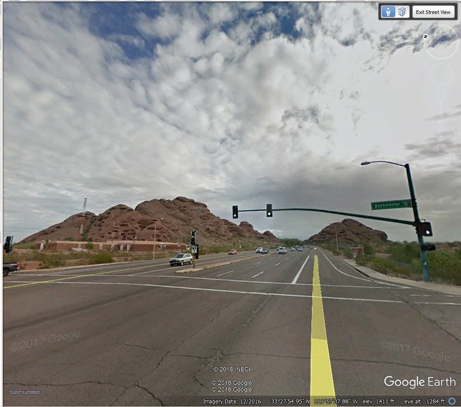
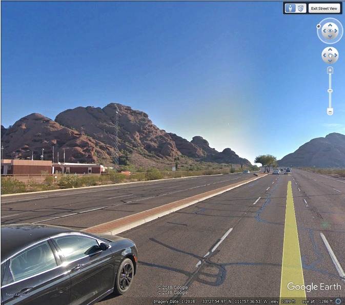
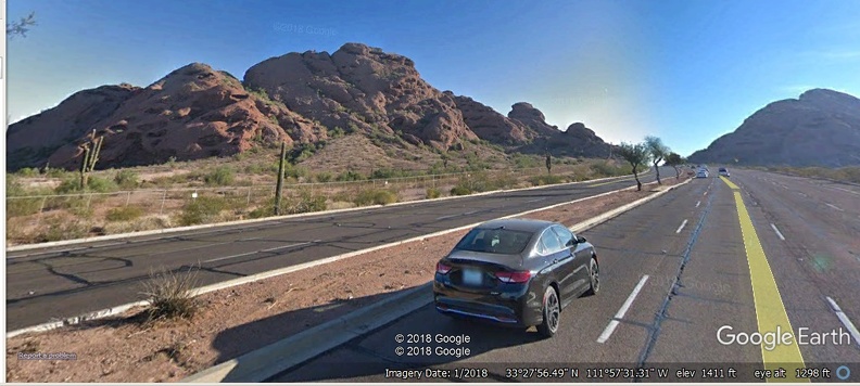
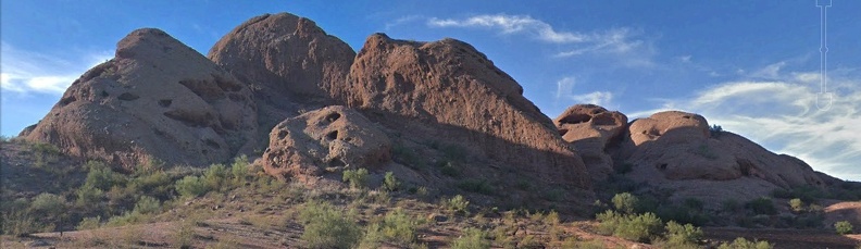
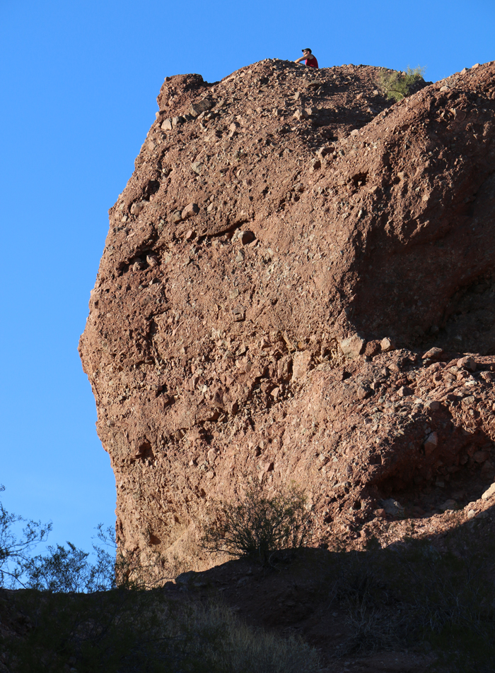
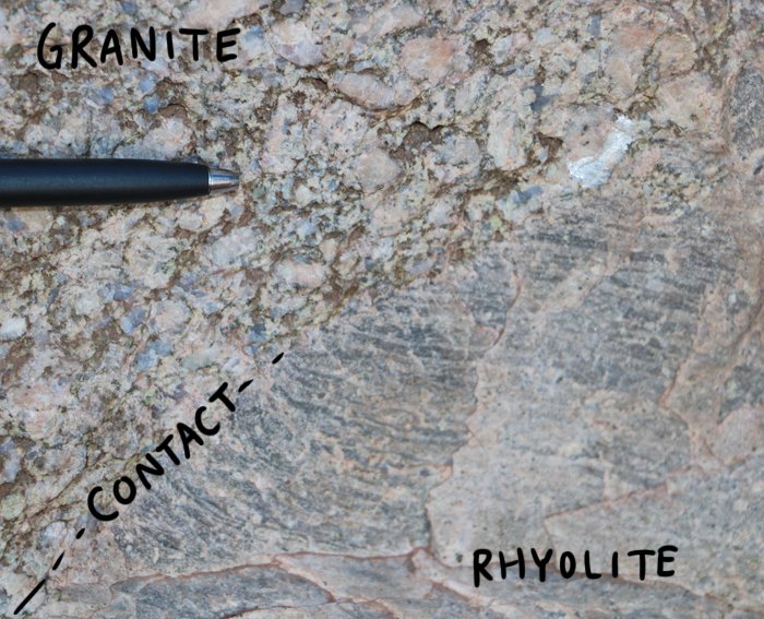
@edmost got me interested in the WEIRD CAVES of the Papago Buttes. Something very unusual happened to form them. I spent most of today (6 July 2017) Googling the northwestern member, Barnes Butte. It has been revealing of something I least expected. Two layers of rock are clearly visible. The South side is mostly pink, while the north is mostly purple because the pink has weathered away. All of the Papago Buttes were capped with a pinkish "Barnes Butte Breccia" - Reddish-brown, course·grained, poorly sorted and stratified fluvial conglomerate. Clasts are 70 to 85% granite and 10 to 20% meta-rhyolite. They are angular to subangular, 1/4 in. to 15 ft (0.7 to 4.5 m) in diameter, in a matrix of rock fragments and ferrugenous cement. The next layer down is a purplish "Zoo Breccia" - Purple to reddish·brown, coarse~grained, unsorted, poorly stratified, massive fluvial conglomerate. Clasts are 30 to 100% meta-rhyolite, 0 to 35%granite, and a small amount of a distinct dacite porphyry. They are angular, 1/4 in, to 2 ft (0.7 to 60 cm) in diameter. The Matrix is a mixture of silt, clay, and ferrugenous cement. Note the difference between the two layers. The pink is mostly large chunks of granite, the purple is mostly smaller pieces of meta-rhyolite and clay. The caves appear to have been formed on the contact zone between the two layers. I suspect saturated clay was the cause of their creation. A Google aerial view of Barnes Butte. North is at the top. The pink and purple layers are clearly visible.  A street view of the south side of Barnes Butte. Note all the caves! Now note the "tongue hanging out" feature of the caves! 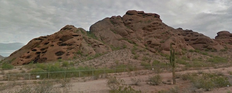 A closer aerial view of the southwest corner. The "tongues" seem to be more purple.  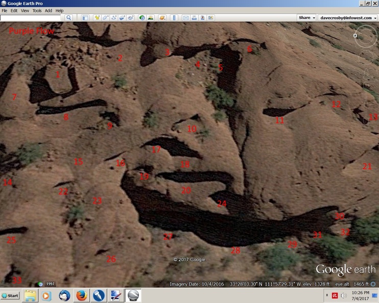 Panning slowly to the north. The pink is mostly gone from the next section, but you can see where the purple material slid to form caves. 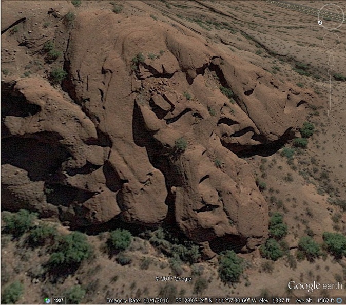 Now looking at the north corner. The pink is gone, but still evidence of caves. Something new is now visible. See the long tongues with no caves? 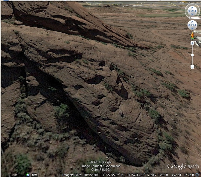 backing away  Backing away even more to look at the north side.  Are you intrigued? |
|
|
|
Post by 1dave on Oct 11, 2020 14:43:21 GMT -7
Yeahbut . . . methinks the caves with tongues sticking out all formed within a month of each other. I never saw any mention of how thick the layers were, but I'm guessing the purple Zoo Member at 30 feet and the pink Barnes Member the same. I'm guessing around 20,000 years ago the granite bases of the Papago Buttes protruded perhaps 50- 100 feet above the valley floor. A. The purple layer came roaring down the Salt River Canyon in an ice melt flood, carrying 2 foot chunks of meta-rhyolite and buries everything 30 feet deep in rock filled mud. It dries. time passes. B. Perhaps a thousand years later a HUGE flood came ripping down, packing up to 15 foot diameter granite boulders and again covers everything about 30 feet deep. C. Almost immediately water seeps down into the clay in the purple layer and on the slopes, the purple starts sliding, dragging purple and pink with it, forming the caves. D. More and more floods scour the valley, deepening it, making the buttes higher.  |
|
|
|
Post by 1dave on Oct 11, 2020 14:45:09 GMT -7
Thanks for looking @metalsmith. The first section (A-B-C) shows the Tcbb purple with big rocks in it to be 300 ft. thick. The next section down (E-F) shows Tcz to be about the same, BUT between (K-L) shows Tcz only ~ 20 feet.
Looking at the pink and purple in the above images, Those thicknesses going down past bedrock do not compute.
The cement is too soft and crumbly. They could not possibly be that old. They would have all worn away long ago - except for the granite blocks.
|
|
|
|
Post by 1dave on Oct 11, 2020 14:45:55 GMT -7
I didn’t realize we referring to the color coding of the GEOLOGIC CROSS SECTIONS OF PAPAGO PARK PEDIMENT TEMPE QUADRANGLE, MARICOPA COUNTY, ARIZONA I was looking for the pink & purple rocks on the buttes themselves But the only thing I ever found red soil, large chucks of granite, rhyolite and some sea shells... Where is Temple Butte in relation? And if I understand your question correctly Tempe Butte or “A” mountain is about 3 mile away just a tad southeast of Barnes Butte. (It doesn't show Tempe Butte in the XS link Tempe Buttes is on the other side of the cropped picture of the baseball stadium about 2 miles away in a southerly direction The view of the picture is taken from the south and may have very well have been taken from the Tempe Buttes ) PLUS-- Tempe Buttes is on the south side of the Salt River Barnes Butte is on the north side of said river. that may be a distinguishing feature.... |
|
|
|
Post by 1dave on Oct 11, 2020 14:47:40 GMT -7
According to the chart the geologist talk Tertiary Age for the Camel Head formation. That is a range between 65 million to 2.58 million years ago. Give or take a few days. Your right Dave! No way those buttes formed 65 million years ago. At the low end is it possible they formed 2 million years ago? That may be in the ballgame But I like the theory that the buttes (themselves) formed only 20,000ya (or even later) That theory makes sense also. It’s the erosion rate that needs to be determined. And how they formed is another matter . Lots of variables… wear down & pockmark wear down & pockmark maybe that process as be going on for millions of years? how big? how much landmass could those mud piles have occupied? Its almost midnight and I'm about to go out there and do some measurements  |
|
|
|
Post by 1dave on Oct 11, 2020 14:49:23 GMT -7
Thanks for looking @metalsmith. The first section (A-B-C) shows the Tcbb purple with big rocks in it to be 300 ft. thick. The next section down (E-F) shows Tcz to be about the same, BUT between (K-L) shows Tcz only ~ 20 feet. Looking at the pink and purple in the above images, Those thicknesses going down past bedrock do not compute. The 20 foot thickness of the Zoo Breccia Member - Tcz - is adjacent to a fault. All of the faults K-L have the down-throw to the RHS. Stratigraphically beneath lies the Basal Member - Tcb - consisting of sandstones and breccia, then there is an irregular surface of the metarhyolite. This indicates an erosional surface. At one point in time the metarhyolite will have been the exposed bedrock (land surface), prior to the erosion and subsequent deposition of all the different breccias which buried it. The 20 foot thick Zoo Breccia Member - Tcz - is only 20 feet thick since its upper surface has been eroded of likely somewhere near 280 feet of material. The faults are all Normal (extensional) fault types, typical of a depositional basin, called Horst Graben. So the tectonic setting is a basin adjacent to an igneous emplacement against which the sediments deposit. If you reverse the fault directions then the units should join back up. The fault just to the RHS of Washington Street should be pushed up on the RHS. Then you can imagine that the purple (on the map) Stadium Breccia unit - Tcs - would join up with the same unit to the left of the Salt River Project. Further to the RHS - towards L - the Zoo Breccia Member - Tcz - lies on top of the erosional surface of the metarhyolite. However, replacing the faults should show the purple (on the map) Stadium Breccia unit - Tcs. So where has Tcz gone? The Zoo Breccia unit overlies the erosional surface of the granite (to the left). The Zoo Breccia Member - Tcz - should lie on top of the erosional surface of the metarhyolite but here it shows (green) Basal Breccia Member - Tcb - and (blue) Zoo Breccia Member - Tcz. This looks like a possible small anomaly unless the Stadium Breccia grades across into the Basal Breccia and Zoo Breccia members. The area below I on the XS G-H-J-I gives some insight into the nature of the metarhyolite / granite boundary. Not all may be quite as simple as the clean downthrow boundary that the Normal fault near L suggests. |
|
|
|
Post by 1dave on Oct 11, 2020 14:51:12 GMT -7
This my take on what the geologist say how the Papago Butte formed There are 5 or 6 distinct geological forces that conspired to bring about the Phoenix Basin. --Major underground uplift during the Proterozoic age. Metamorphic rocks, including metavolcanic rocks, metasedimentary rocks, and foliated to gneissic plutonic rocks were rumbling & tumbling deep in the earth. Eventually creating some sort of stable bedrock --Sometime during the early Tertiary period volcanic ash & lava flow (from the Superstition Mountains eruptions) seriously covered the area. --Then there was Basin fill from a huge mountain that crumbed into a landslide. 7000 feet tall. This mountain no longer exist. --Salt River gravels then invaded the area transported by the Salt River. If you ever travel the Salt River Canyon your in for a real treat and can imagine the amount earth excavated that created the Canyon. ---Lastly there is Uppermost Alluvium deposits. --So all these layers built on top of one another over millenniums. Unimaginable thickness! Then the South Mountain Metamorphic Complex (SMMC) occurred. This further ripped and buckled the land. This is what raised & lifted the buttes as they altered and shifted their strata layers. Well that my synopsis Lots of holes & pockmarks in it But as those geologist remarked: There are million of years of geological history not accounted for, lost in the recipe. So some speculation will have to suffice… mostly |
|
|
|
Post by 1dave on Oct 11, 2020 14:52:06 GMT -7
Yes, the GREAT UNCONFORMITY. Something spectacular happened around 550 million years ago that washed away over a million years of rocks.
For a long time I thought that was when earth was hit by another planet and our moon was formed. I've since been convinced that happened over 4 billion years ago and started continental drift.
Could an ice age end have been that drastic? Very possible. The first rocks laid down on the top of the unconformity are huge boulders.
|
|
|
|
Post by 1dave on Oct 11, 2020 14:53:10 GMT -7
Yes, the GREAT UNCONFORMITY. Something spectacular happened around 550 million years ago that washed away over a million years of rocks. has a reasonably accessible explanation of Phoenix geology. There is ~ billion years of missing geological record. Why it doesn't exist and whether it was washed away - not sure whether you meant literally or figuratively. See the map showing the Late Proterozoic sea - link and more geo exploring fun here - the reason why the sediments were deposited would be topographic difference: gravity providing the energy to move huge boulders & tectonic activity likely to get the ball rolling so to speak. Figure 1 of Rasmussen shows the physiographic provinces. |
|
|
|
Post by 1dave on Oct 11, 2020 14:54:03 GMT -7
Its funny about the Dreamy Draw Mercury Mines. Back in the day circa 1970 Many of us would go into those boondocks & do whatever crazy teens do We entered those cinnabar mines didn't really know what their purpose was at the time ( seriously dynamited blasted out cave in the side of that hard rock mountain about 50 feet deep) One in our party claimed they had been bitten by a bat So with just a flashlight & a fishing net we caught a bat We then put the bat in the glove compartment of the truck Back at the house we called Humane Society to have the bat tested for rabies. I think the official thought we were kidding when we told him the bat was in the glove compartment. He got in the truck and when he opened the glove compartment It was a bat out of hell! That bat was large. Flying about tying to escape in that small area. But that dude captured it and the bat didn’t have rabies. |
|
|
|
Post by 1dave on Oct 11, 2020 14:55:03 GMT -7
Yes, the GREAT UNCONFORMITY. Something spectacular happened around 550 million years ago that washed away over a million years of rocks. has a reasonably accessible explanation of Phoenix geology. There is ~ billion years of missing geological record. Why it doesn't exist and whether it was washed away - not sure whether you meant literally or figuratively. See the map showing the Late Proterozoic sea - link and more geo exploring fun here - the reason why the sediments were deposited would be topographic difference: gravity providing the energy to move huge boulders & tectonic activity likely to get the ball rolling so to speak. Figure 1 of Rasmussen shows the physiographic provinces. THANKS! You always come up with great research! Finally I find out what "Dreamy Draw" was all about! |
|
|
|
Post by Admin on Mar 2, 2021 10:09:28 GMT -7
|
|
|
|
Post by Admin on Mar 2, 2021 10:10:26 GMT -7
|
|
|
|
Post by Admin on Mar 2, 2021 10:11:40 GMT -7
Thanks Dave ya save me a trip even though it only mile or two down that rocky road my car over heat no refer and it hot & humid about I did make it Burton Barr yesterday and did some more studying on the Lost City of Cibola hard to follow Peterson when he indicates that a river, canal, Hohokam settlement were on the east side of the buttes but he does mention Indian Bend Wash which present possibilities tell your grand son welcome to Phoenix heck of time to be here I almost worked for State Farm at the 52nd St facility they had there major print operations there... |
|
|
|
Post by Admin on Mar 2, 2021 10:12:58 GMT -7
|
|