|
|
Post by Admin on Jun 3, 2022 17:45:57 GMT -7
@jamesp the geologists are going to be thrilled at your discovery. I'm sure your pet wood was emplaced by the tidal wave from Chicxilub ~ 1,000 miles south southeast of there.  But then they won't let anyone pick up so much as a dust mote.  Unless YOU own the land. Then they have no say.  You could invite good friends to purchase good lots in the neighborhood(s) Being silent is my best bet. Thanks for the advise. Telling the geologist may be as troublesome as telling collectors wouldn't you think ? I feel strongly that this deposit was placed by a powerful force of wave action on a shore from the west and not from the south by chicxulub. However a large wave of water generated by that meteor may have been forced down this large drainage aligned exactly west(draining from the east) containing about 50 creeks. Plus the volcanic ash covering the area had to come from the north and north east suggesting runoff off the Morrison formation area. A temporary constant level Fall Line ocean that quickly filled and quickly drained makes more sense looking at the topography. The +/-20 feet deep deposit matches a persisting shoreline perfectly. It is a narrow(east to west) but long deposit(north to south) depositing on a very narrow elevation difference which suggests a shoreline closely. Looks like a flood event to me. About 4 to 5 thousand years ago   |
|
|
|
Post by Admin on Jun 3, 2022 17:47:03 GMT -7
The big pieces are actually better silicified go figure. They require a pack mule though. No shortage of big chunks on site. This 35 pounder was cross cut and as usual shows little evidence of growth rings dang it. Maybe slightly in the close up. Next cut will be quarter sawn tomorrow and will show nice quarter grain. Mouth full for 18 inch saw:  Lack of obvious growth rings:  judging from slight radial swirl markings center of tree looks to be at upper right of photo. Will use as reference for quarter sawing.: 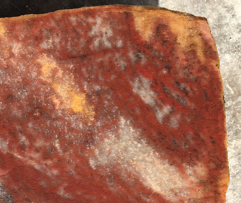 ##############################  |
|
|
|
Post by Admin on Jun 4, 2022 8:29:05 GMT -7
So the 35 pound block sawed out to a lot of lapidary grade(ok in my opinion) material. The block was cross cut, quarter cut and flat cut(lumber sawing terminologies). The entirety of the block(why couldn't it have been 50% Australian grade fire opal fill !!). Quarter sawn at upper left, flat sawn upper right, and cross cut lower left and lower right:  Close up of quarter sawn along edge and somewhat bleached out for it. Pick a more internal cut to get the deeper reds or black zones:  Close up of flat sawn, these are often with blotchy patterns, rich red and not bleached:  and a repeat of the cross sawn version for comparison purposes: |
|
|
|
Post by Admin on Jun 4, 2022 8:33:24 GMT -7
I LOVE the internal stain, but the rind seems to be back to the original color. The wild colors we see for sale prove agate is easily stained, I had no idea it happened in a week just in the creak. It probably takes a while to creek stain, like a year or two for the creek to lay a stain down. I just had seen that specimen down in the creek when collecting from the unstained banks. Even in the creek there are differences in color even when stained. But when non-stained the colors really show for picking the best specimens. the stain is a visual hindrance. The wood is constantly rolling out of the banks and into the creek. But the ones that are 'plucked' out of the clay under creek water level exposed by the creek erosion are really well silicified. I am guessing they silicified in place under water table with full time moisture supply. No moisture - no silicification... I sawed thru the bark on this same sample. It was at an angle due to saw clamping limitations so the bark is half that thick. Bark is 5/8" thick. The bark petrified terribly, it is pithy, which makes perfect sense since bark is there to keep bugs and fungus from penetrating to the delicate vascular system. Like a protective cover without capillaries. The vascular system of this wood is well silicified probably due to high performance transport capillary systems for transporting water, nutrients and CO2 found in tropical plants probably allowing silica into it's vascular center. Now that it is known some of this wood has bark it may help to know what type of a plant this is. Devil's in the details... bark to left, grain running vertically, wood basically quarter sawn: 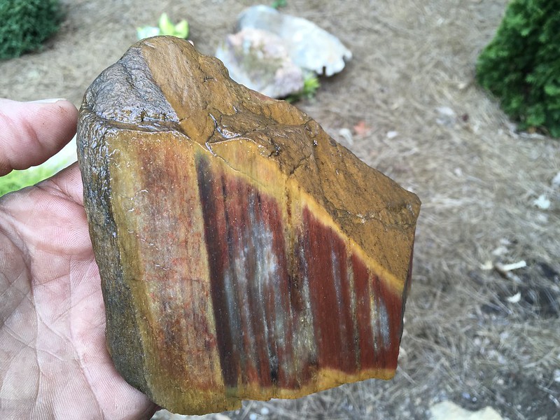 another view of bark before sawing:  |
|
|
|
Post by Admin on Jun 5, 2022 10:35:56 GMT -7
These are some of the maps of topography, soils, hydrology and drainages that sent me to this location in the first place.  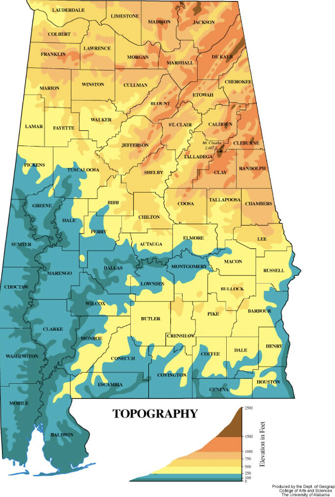 This is a soil map. Wetland soils close to the 350 foot sea elevation line up at Macon County on flood plains and terraces. 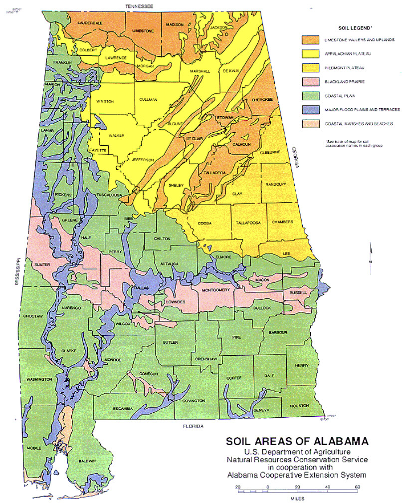 |
|
|
|
Post by Admin on Jun 5, 2022 10:39:36 GMT -7
@jamesp OK, Jim you got us doing more research down here , pulling out the book you also likely have
"Lost Worlds in Alabama Rocks" .
I'm not sure Tom or I ever truly read the whole thing, and quickly told ourselves that all the cool rocks & formations were in way north Al.
Well now your theory is quite interesting , and has us rethinking that maybe there's some, down this way after all. Interestingly, in that book, they show a picture of petrified wood that looks very much like the stuff your finding, but from Barbour county, in the SE part of the state.
Now that's within a distance that we could go poke around creeks and look. There's even a couple of corp of engineers campgrounds there.
Thank you for the added research on your part Patty
Basically the entire half of the Alabama state below the Fall Line is likely to have it. One friend takes groups all over Bama on kayak trips, pet wood being one of their collecting targets and they find it on most of those drainages. They prefer to kayak the sloped land along the Fall Line where the water moves a bit faster. Yes Barbour County is one of 4 counties listed in one rock book, another rock book listed other County's. And I knew the Chattahoochee River drainage in south Alabama was a place pet wood could be found close to or in Barbour County. But most of the wood counties were along the Fall Line. The more research and asking around I do the more I find more locations for it. There are 3 counties west of the Escambia River in the Mississippi state line that are known for their whale fossils. Here is a drainage map of those rivers mentioned. East Barbour County would be on the Chattahoochee drainage. The west side would be Pea Creek and Linsey Creek drainages flowing to the south west. And the east side of Barbour County would be almost entirely the west shore of Walter George Reservoir which may be a great place to collect when the reservoir is low in the summer. Good luck there ! PS Georgia collectors all think north Georgia is the only place to go. Most are not aware of the fine rocks at the coastal plain.  |
|
|
|
Post by Admin on Jun 5, 2022 10:42:11 GMT -7
These would have likely been cold weather conifer and/or ginko species. The piles of logs would have been unimaginable.  |
|
|
|
Post by Admin on Jun 5, 2022 10:49:29 GMT -7
Interesting discussion. I've always been confused how in south Texas near George West, where again the silica must come from marine fossils with silica skeletons, the wood is both colorful and very hard and silica replaced. Yet, here locally, though we rarely find a hunk, of agatized wood, most the wood is replaced by calcite. Yet the same silica bearing fossil layers are present, but I guess not correctly overlaying the buried wood. I've actually been to a ranch where the whole hillside was petrified longs, all calcite replaced and soft. Very frustrating. Not a gemmy, colorful, hunk to be found. I had the same question Mel. The Rio and George wood is beautifully silicified. The Rio area may be imported ash related silicification but the George West wood must be formed by silica skeletons as is other local Texas pet wood north of the Rio. Limestone bedrock exposures in south Texas were covered with monocultures of similarly silicified pet wood depending on which limestone exposure you were collecting on. A shame about the large crop of calcite replacements. Darwin Dillon moved to Beeville TX next to George West for good reason. The gravel roads there are loaded with fine palm and wood. In addition to this Alabama wood is massive plates of banded chert base rock(death plate ?) that vary from a few inches thick to two feet thick. Most of it is in the creek bottom but also mixed with the wood on higher ground. But when broken the face glitters as if compressed sand bonded by silica similar to Tallahatta quartzite. But the bottom of the wood and chert rich creek is underlaid by crystalline quartz bedrock and no limestone. Here is a 4 inch thick hammer broken sample of this chert bed plate wetted. It can be quite attractive and takes a fine tumble polish.: 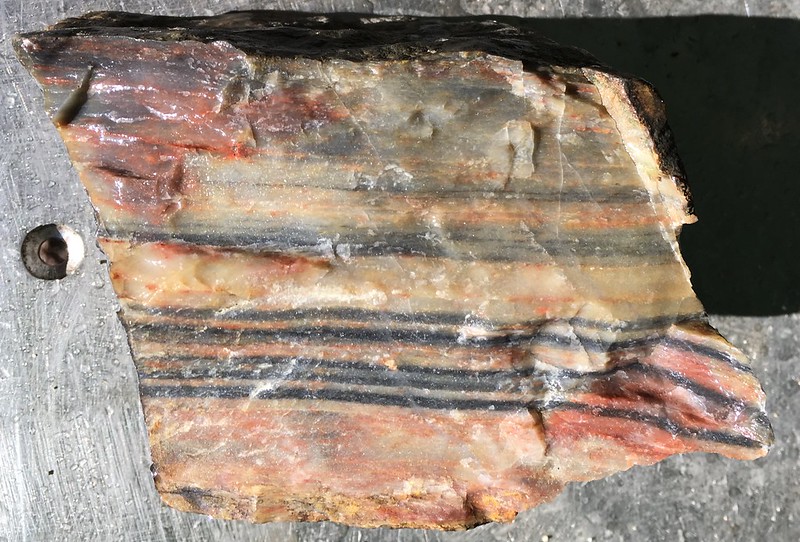 But this hammer broken face glitters as if pure quartzite. This dry photo does not do the full coverage glitter justice. It is as if this is quartzite bonded together with dissolved silica like Tallahatta yet some of it is nicely translucent. Colors range in the iron spectrum including crazy dark purples.: 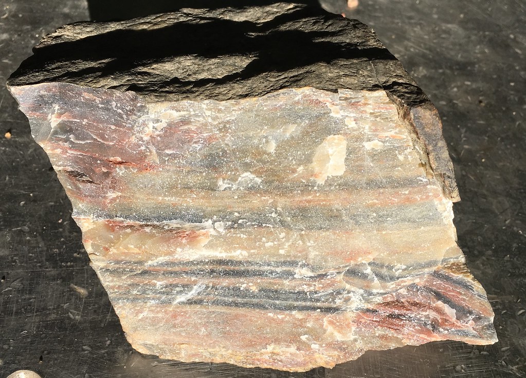 I sure wish you could go to this site. Your vast experience with silicified materials would sure be helpful. I was going to ask if I could send you an MFRB for your to analyze. I have a few tumble polished pieces to add to the samples if that helps. |
|
|
|
Post by Admin on Jun 5, 2022 10:52:34 GMT -7
Found an excellent U. of S. Bama geological article on Tallahatta (NOT) quartzite. It is not quartzite but is silicified sandstone meaning it did not experience metamorphosis ! It is sandstone cemented together by opaline silica or chalcedony silica. And there is volcanic ash present in south Alabama. Killer article... www.geoarchaeology.southalabama.edu/tal-sand_home.html"To most archaeologists, lithic tools composed of this rock type are referred to as "Tallahatta Quartzite". Tallahatta comes from the geological formation name. Quartzite was once used as a designation for a quartz-rich sedimentary rock (Pettijohn, 1957). However, the term is more commonly employed today to designate metamorphosed quartz-rich sandstone. Since the rocks comprising the Tallahatta Formation have not been metamorphosed, quartzite is an incorrect rock classification for lithic tools made from these material. A more acceptable classification that is consistent with geological nomenclature is Tallahatta Sandstone." Mention of both marine fossils and PETRIFIED WOOD ! "Sandstone and occasionally pebbly sandstone intervals also occur in the Tallahatta Formation and are particularly important for archaeological reasons as they provided the materials for lithic tools in south Alabama. The sandstone is technically classified as quartz arenite (Folk, 1954), as the majority of the grains (>95% of total particles) are composed of quartz. Most quartz grains are moderately well-sorted, sub-angular to sub-rounded in shape, and fine to medium in size. Accessory minerals (those present in trace quantities) include glauconite, muscovite, magnetite, ilmenite, garnet and glaucophane. Occasional petrified wood fragments (Counts and Savrda, 2004) and carbonaceous material (fossil wood fragments) are also found in the Tallahatta Formation (especially in lower portions). Some sandstones and claystones also contain marine shells (e.g., Discocyclina advena, Protoscutella mississippiensis, and Ostrea spp.; Copeland, 1968), and trace fossils of shallow marine origin (e.g., Ophiomorpha nodosa). The most likely depositional environment for the Tallahatta Formation was beach-shelf." And they say volcanic ash is present in south Alabama lol. @#$%^ "The Tallahatta Formation consists of several types of siliciclastic sedimentary rocks. The dominant lithology is micaceous sandy claystone. It is thick-bedded, massive, and contains abundant trace fossils and burrows. A study by Schroeder and Harris (2004) in Mississippi determined that the claystone contained significant amounts of opal-CT (essentially non-crystalline quartz) and the zeolite mineral clinoptilolite. The presence of both of these minerals are significant as they are thought to be alteration productions derived from volcanic ash. Indeed, Schroeder and Harris (2004) imply that much of the fine sediment in the Tallahatta Formation in Mississippi was derived from a volcanic source." "The Tallahatta Formation is composed of "pale-green marine siliceous claystone with some beds of glauconitic sand and sandstone" (Copeland, 1968). It contains some fossiliferous intervals in southwestern portions of the state. Fossils also occur in south central Alabama, but lower in the stratigraphy." 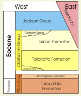 Tallahatta named after the "Tallahatta Hills" in Choctaw County Alabama. Hoping not to find Billie Joe ! |
|
|
|
Post by Admin on Jun 5, 2022 14:26:39 GMT -7
@jamesp , After looking at your images, In my minds eye, I see "1,000 mph wind 1500 degree knocking down and drying out every tree from Mississippi to Georgia, and piling them up in every low place. The drying caused ALL of the wood to checker. Some time later a series of huge waves, washing and burying them. Erosion finally exposing them in our time.   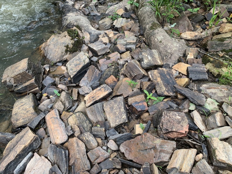 |
|
|
|
Post by Admin on Jun 10, 2022 10:10:52 GMT -7
Not even US? We won't be able to see all the above photos? How can ye be sae cruel? I finally hiked thru the flood plain along the creek to the south maybe 1/2 mile. This property suffers from extreme farming abuse and has had serious erosion problems. Downstream it became apparent just how erosion damaged the property is but is a blessing for the pet wood hunter. Truck loads of bigger 50 to 100 pound chunks. Not sure how far this float goes, at least 1/4 mile and 50 yards wide. Wow. Next trip the hike will be yet further south. 2 miles south to next gravel road but gets swampy. Best selection ever but a hell hike to get it out of there. Talk about a killer pet wood log xeriscape this spot would be the go to. A shame most of the wood is riddled with fractures and the silicification colors were more diverse. This is the floodplain, normally it should be silt 10 feet deep instead of being covered with pet wood !  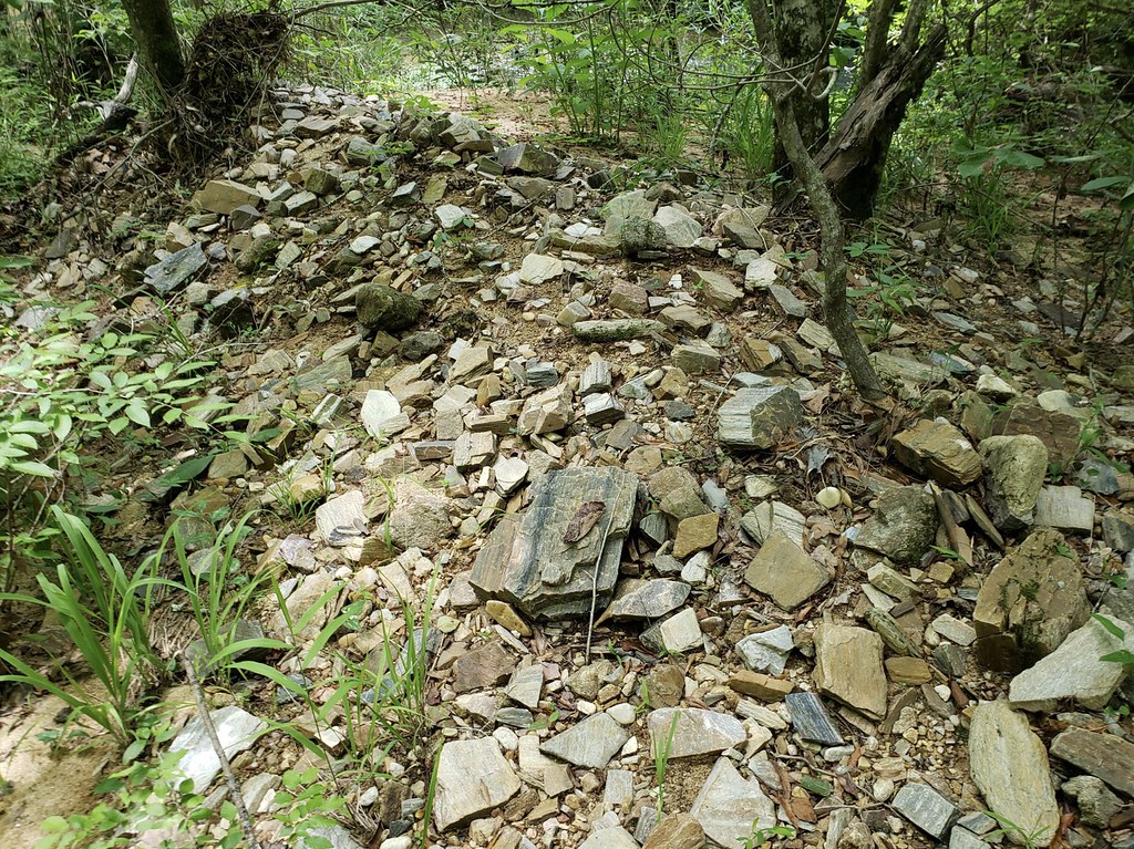 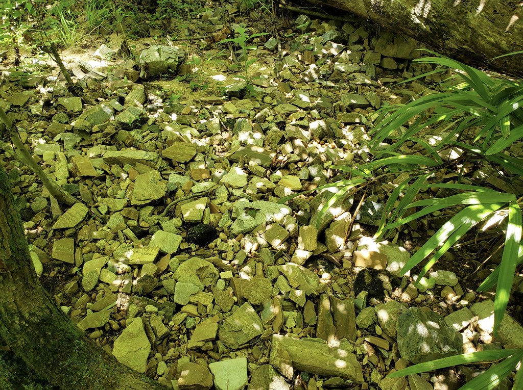 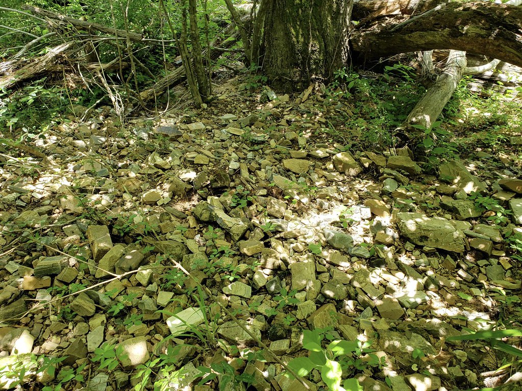 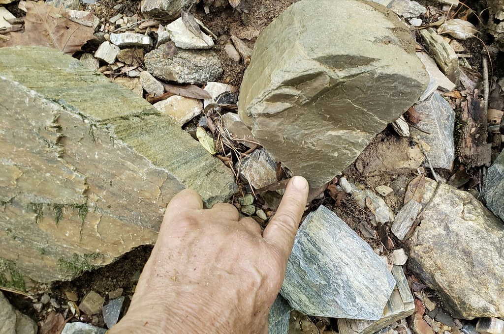 Judging from the banks of the creek the pet wood is loaded in the adjacent floodplain too   Plenty of 200 year old pines and hardwoods for shade. Nice water oak. Killer variety of wetland forest herbaceous plants. Poison Ivy is terrible though. I am covered up, it even made it under the thick skin of my hands causing intense itching. That was a first.  |
|
|
|
Post by Admin on Jun 11, 2022 14:26:52 GMT -7
|
|
|
|
Post by Admin on Jun 11, 2022 22:15:35 GMT -7
 Go to Youtube. |
|
|
|
Post by Admin on Jun 17, 2022 7:48:51 GMT -7
I'm a native Idahoan and have been to the Cobalt mining area many times. The water's great. But maybe you'll take my statement with a grain of salt, with me being an Idahoan and having drunk the water I will gladly apologize if I was offensive in my statement. The rich metal content does give rise to the question on water quality. We have iron rich water that stains plumbing fixtures but for all I know it is a healthy source of iron when consumed. Just saying that some of those metals are so toxic and one would think that many wells would produce non potable water. Then again look at plant fertilizers(perhaps I should have considered this before making those statements). They have plenty of toxic metals. The plants prosper(or must have to survive) from them in the correct doses and chelated form. 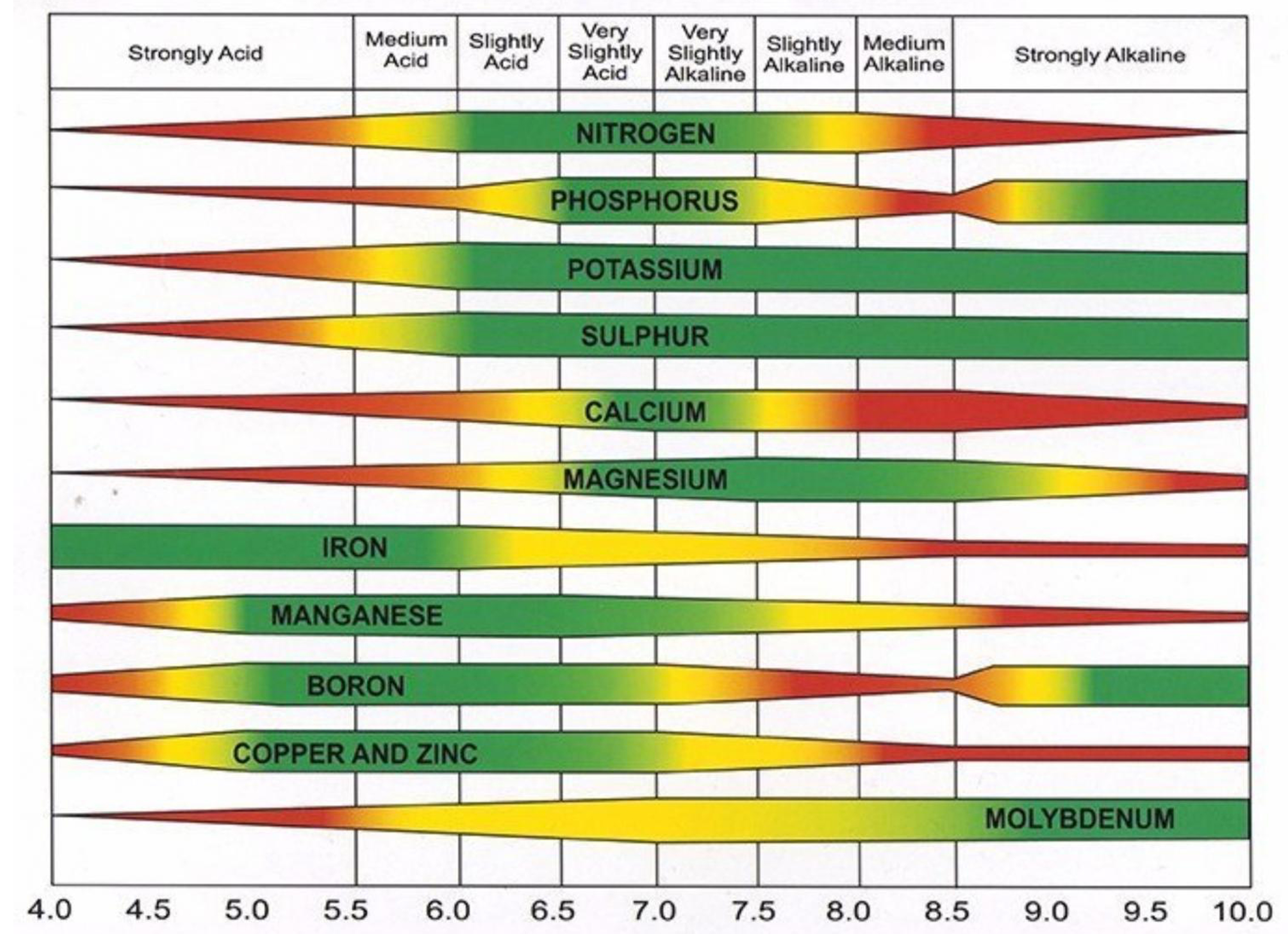 |
|
|
|
Post by Admin on Jun 17, 2022 7:53:12 GMT -7
I don't understand this chart. Tapered part means not so much in this area ? but the colors? Green = good here, yellow means Who knows?, red = bad? |
|


 You could invite good friends to purchase good lots in the neighborhood(s)
