Post by Admin on Jul 2, 2022 10:40:22 GMT -7
Welcome to Brian Head Utah

blob:https://giw.utahgeology.org/3f309680-1d07-41be-aa7e-e0127ab55b36


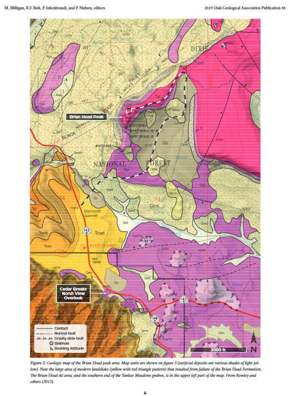
Figure 2. Geologic map of the Brian Head peak area. Map units are shown on figure 3 (surficial deposits are various shades of light yellow). Note the large area of modern landslides (yellow with red triangle pattern) that resulted from failure of the Brian Head Formation. The Brian Head ski area, and the southern end of the Yankee Meadows graben, is in the upper left part of the map. From Rowley and others (2013).
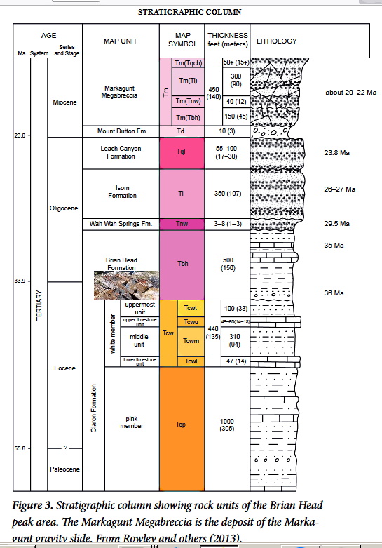
The Brian Head Formation is characterized by white volcaniclastic mudstone, siltstone, sandstone, volcanic ash, muddy limestone, and minor conglomerate and multi-hued chalcedony, and it is known for its propensity for landsliding. These strata, rich in volcanic ash, were deposited in low-relief fluvial, floodplain, and lacustrine environments; they record the inception of volcanism in southwest Utah beginning about 37 million years ago (Sable and Maldonado, 1997) (figure 8). The base of the section is well exposed near the North Rim Overlook in Cedar Breaks National Monument; there, a thin rhyolitic ash bed overlies a thin pebbly conglomerate likely equivalent to the conglomerate at Boat Mesa in Bryce Canyon National Park. This ash bed yielded a U-Pb age on zircon of 35.77 ± 0.28 Ma, and several additional radiometric ages from Brian Head strata throughout the region show that it was deposited from about 37 to 33 million years ago (Biek and others, 2015). Thus, it is mostly late Eocene in age, barely reaching into the Oligocene.
The Brian Head Formation contains abundant trace fossils, including possible crayfish burrows and root traces (Golder and Wizevich, 2009; Golder and others, 2009), but aside from its basal variegated interval it is surprisingly unfossiliferous (Eaton and others, 1999). It also has colorful beds of chalcedony in various shades of white, gray, yellow, red, black, and brown, all typically with a white weathering rind. The chalcedony forms resistant beds as much as 10 feet (3 m) thick and is thought to have resulted from silicification of limestone beds (Maldonado, 1995; Sable and Maldonado,
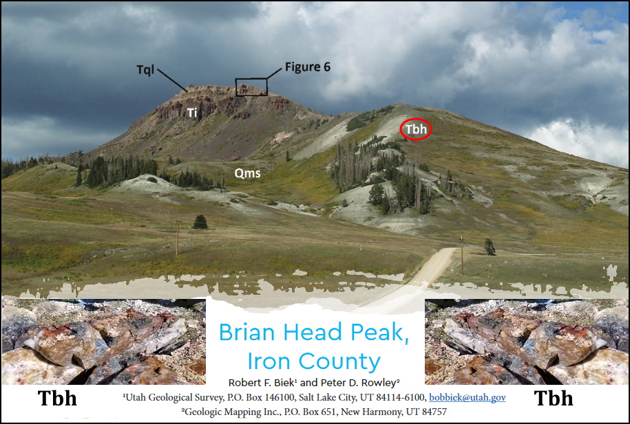
Figure 6. Leach Canyon Formation on the south side of Brian Head peak. Here, the classic three-part section of an ash-flow tuff is exposed, including an unwelded basal surge deposit, a thick vitrophyre, and moderately welded ash-flow tuff that caps Brian Head peak. A flow breccia of the Isom Formation (Ti) is present in the lower left corner of the photograph.
Figure 7. A. The resistant Isom Formation at Black Ledge, looking south towards Brian Head peak. B. Contorted flow layering of this densely welded ash-flow tuff, an example of its rheomorphic nature.
Above all, however, the Brian Head Formation is known for its swelling soils and for its susceptibility to landsliding. Nearly all exposures on steep hillsides form large landslide complexes, including one that fills the 15-mile (24 km) length of Yankee Meadows graben, home to the resort town of Brian Head. The formation is susceptible to landslides because of its abundant clay derived from weathered volcanic ash.
A more complete section of the Brian Head Formation is well exposed on the southwest flank of the Sevier Plateau (figure 9). There, a transitional interval as much as 160 feet (50 m) thick, not present elsewhere, of fine-grained, slope-forming sandstone, siltstone, and mudstone of red, pink, yellowish-brown, and purplish-gray hues forms the base of the formation. This variegated interval yielded fossil turtles, charophytes (freshwater green algae), and fish suggestive of lacustrine environments of the Duchesnean North American Land Mammal Age (end of middle Eocene) (Feist and others, 1997; Eaton and others, 1999; Korth and Eaton, 2004)

blob:https://giw.utahgeology.org/3f309680-1d07-41be-aa7e-e0127ab55b36


Figure 2. Geologic map of the Brian Head peak area. Map units are shown on figure 3 (surficial deposits are various shades of light yellow). Note the large area of modern landslides (yellow with red triangle pattern) that resulted from failure of the Brian Head Formation. The Brian Head ski area, and the southern end of the Yankee Meadows graben, is in the upper left part of the map. From Rowley and others (2013).
The Brian Head Formation is characterized by white volcaniclastic mudstone, siltstone, sandstone, volcanic ash, muddy limestone, and minor conglomerate and multi-hued chalcedony, and it is known for its propensity for landsliding. These strata, rich in volcanic ash, were deposited in low-relief fluvial, floodplain, and lacustrine environments; they record the inception of volcanism in southwest Utah beginning about 37 million years ago (Sable and Maldonado, 1997) (figure 8). The base of the section is well exposed near the North Rim Overlook in Cedar Breaks National Monument; there, a thin rhyolitic ash bed overlies a thin pebbly conglomerate likely equivalent to the conglomerate at Boat Mesa in Bryce Canyon National Park. This ash bed yielded a U-Pb age on zircon of 35.77 ± 0.28 Ma, and several additional radiometric ages from Brian Head strata throughout the region show that it was deposited from about 37 to 33 million years ago (Biek and others, 2015). Thus, it is mostly late Eocene in age, barely reaching into the Oligocene.
The Brian Head Formation contains abundant trace fossils, including possible crayfish burrows and root traces (Golder and Wizevich, 2009; Golder and others, 2009), but aside from its basal variegated interval it is surprisingly unfossiliferous (Eaton and others, 1999). It also has colorful beds of chalcedony in various shades of white, gray, yellow, red, black, and brown, all typically with a white weathering rind. The chalcedony forms resistant beds as much as 10 feet (3 m) thick and is thought to have resulted from silicification of limestone beds (Maldonado, 1995; Sable and Maldonado,
Figure 6. Leach Canyon Formation on the south side of Brian Head peak. Here, the classic three-part section of an ash-flow tuff is exposed, including an unwelded basal surge deposit, a thick vitrophyre, and moderately welded ash-flow tuff that caps Brian Head peak. A flow breccia of the Isom Formation (Ti) is present in the lower left corner of the photograph.
Figure 7. A. The resistant Isom Formation at Black Ledge, looking south towards Brian Head peak. B. Contorted flow layering of this densely welded ash-flow tuff, an example of its rheomorphic nature.
Above all, however, the Brian Head Formation is known for its swelling soils and for its susceptibility to landsliding. Nearly all exposures on steep hillsides form large landslide complexes, including one that fills the 15-mile (24 km) length of Yankee Meadows graben, home to the resort town of Brian Head. The formation is susceptible to landslides because of its abundant clay derived from weathered volcanic ash.
A more complete section of the Brian Head Formation is well exposed on the southwest flank of the Sevier Plateau (figure 9). There, a transitional interval as much as 160 feet (50 m) thick, not present elsewhere, of fine-grained, slope-forming sandstone, siltstone, and mudstone of red, pink, yellowish-brown, and purplish-gray hues forms the base of the formation. This variegated interval yielded fossil turtles, charophytes (freshwater green algae), and fish suggestive of lacustrine environments of the Duchesnean North American Land Mammal Age (end of middle Eocene) (Feist and others, 1997; Eaton and others, 1999; Korth and Eaton, 2004)
