|
|
Post by 1dave on Sept 7, 2020 12:29:34 GMT -7
THIS NEEDS TO BE TOTALLY RE-DONE
When looking for fossils, knowing WHEN to look is as important as knowing Where to look.Scientists have found around 25 layers of rocks where huge collections of fossils are found. Geologists have divided the geology record into 12 time periods bracketed by moments of massive extinctions.What caused these massive Die-Offs? 1. Asteroid Impacts2. Continental Collisions - Ron Blakey!3. Flood Volcanics 4. Ice Ages 5. Tsunamis 6. Drought Click on an ORANGE time period to go directly to it. What caused those extinctions?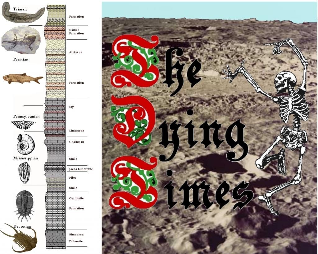 There has been a lot of speculation about a "Death Star" that kills off life every 62 (or 31) million years, 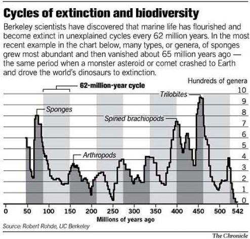 but our Cenozoic has lasted 63.2 million million years with no shattering happening when the Tertiary ended and our present Quaternary began 1.8 million years ago. That didn't seem plausible to me, so I began my own research. 1. Scientists have concluded the universe is 13.8 Billion years old.I believe there was a supernova that created a Black Hole in a prior universe. We were sucked in.
That was our "big Bang" and we are in a black hole. 2. the Milky Way Galaxy is about 13.2 Billion years old. Scientists have discovered galaxies average one supernova about every hundred years, so we are surrounded by around 132 million supernova remnants.  360 degree view of the Milky Way from Earth showing "dust" in our area. 3. the Sun, solar system, and earth coalesced from that material about 4.54 Billion years ago.Present theory is that the planets formed from dust rings around the sun.  More probable to me More probable to me is the idea that Sol, like most stars, had a partner, but it was drawn out like a string of soap bubbles by a passing massive star. Those "bubbles" became most of our planets.  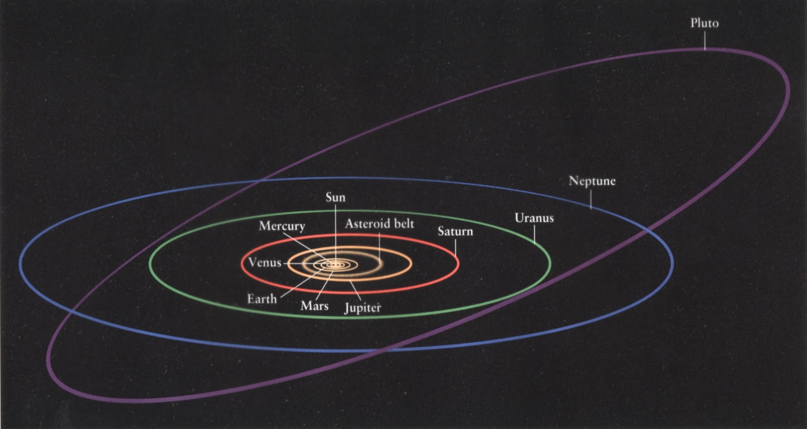 Pluto and many planetary moons obviously came from somewhere else. Pluto and many planetary moons obviously came from somewhere else. Is each arm the remnant of a captured galaxy? We return to our birthplace every 226 million years (one Galactic Year), but supernova material travels out at 1/10th the speed of light, so every ten years it has scattered one light year further from it's original center. You can't step in the same river twice. Each full trip allows the material to expand its radius by (226m/10 =) 22 million light years, but all is still part of the Milky Way dust and larger particles we travel through. Divide 4.54 Billion by 226 Million years per trip = about 20 full trips we have made around the galaxy so far. 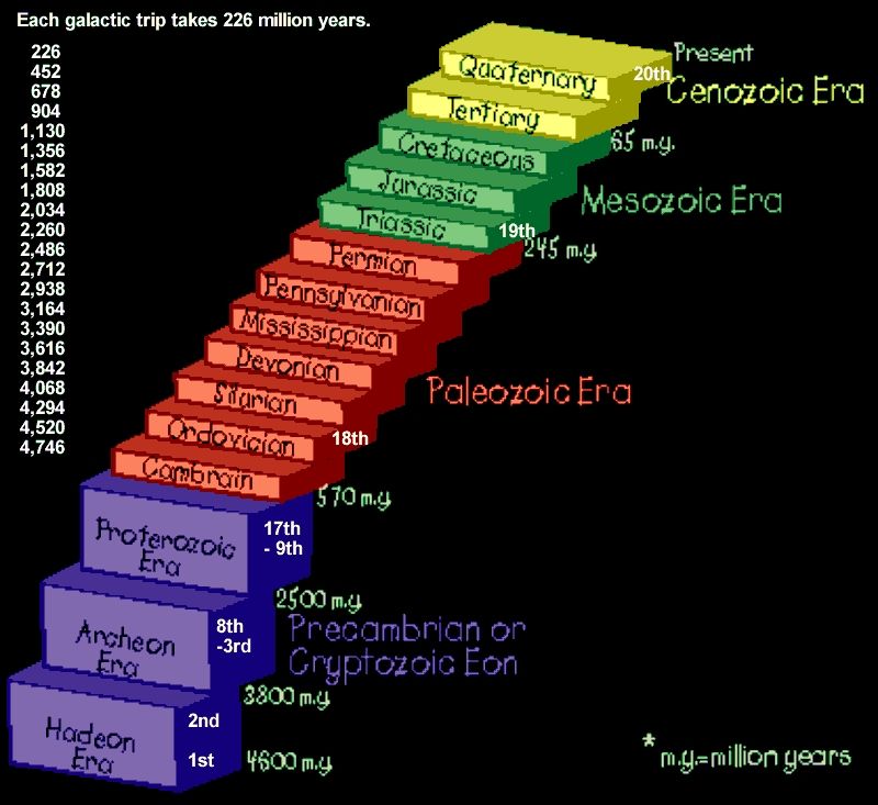 Supernovae nebulae clutter Sun and Earth’s 226 million year path around the Milky Way galaxy, like flack shot at WWII aircraft. The elements (oxygen, silicon, silver, gold, uranium)in the “flack” depends on the mass of the star before it exploded. An excellent presentation on supernovas is at: abyss.uoregon.edu/~js/ast122/lectures/lec18.html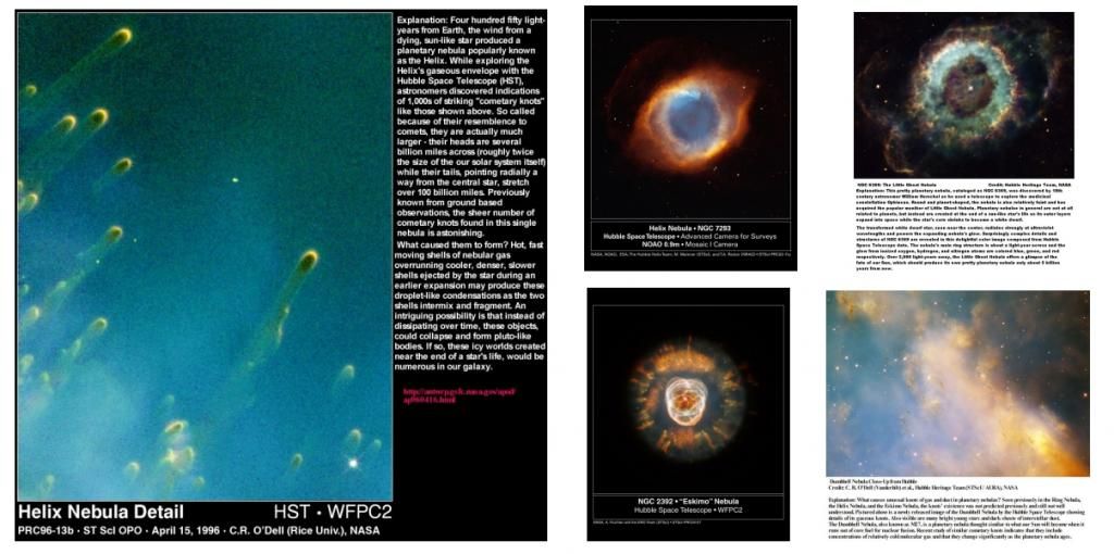 Heavy elements in massive supernovas often have enough mass to draw huge spherical clouds of material to them. Known as "cometary Knots", each of those shown in the Helix Nebula are about twice the diameter of our entire solar system, but contain about the mass of Pluto. Sorry, I don't believe in the Oort Cloud Myth. Supernovas are where our comets and most asteroids come from.  Remember the 39 members of the Heaven's Gate cult (of course California) who tried to "hitch a ride on the space ship" following the comet? The last week of March 1997.  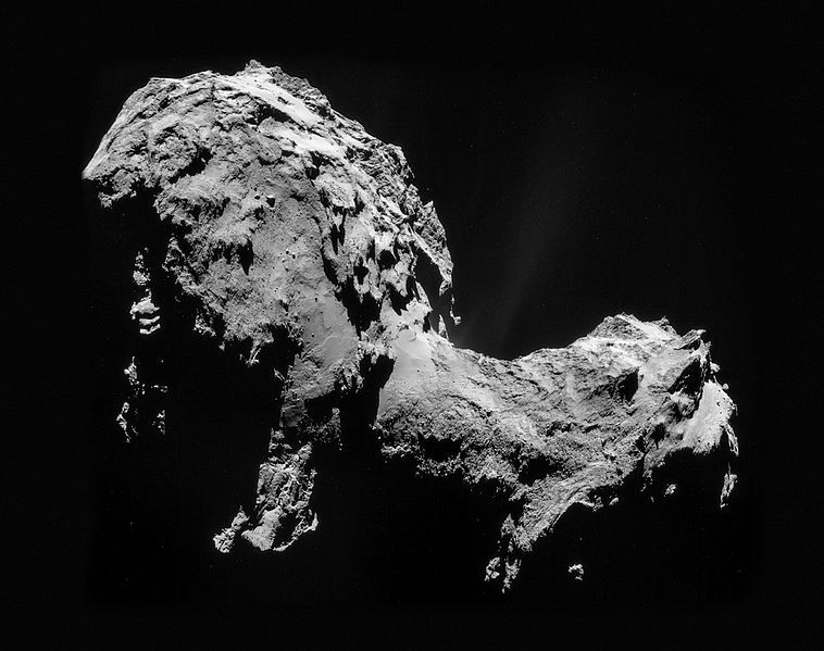 Comet 67p  Miranda, a moon of Uranus, could be the mashed together end results from a cometary knot. Joined together pieces, like scoops of ice cream, from long deep space trips with little outside influence for millions of years are evident in many comets and asteroids. 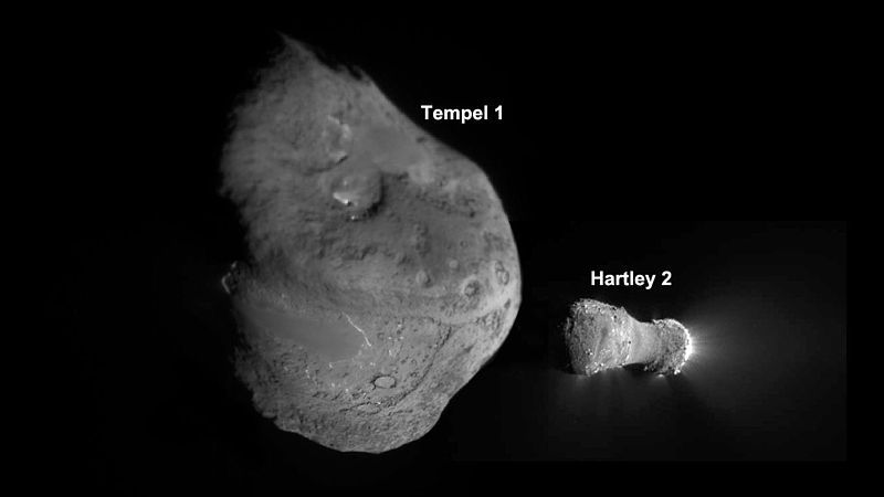 Comets Tempel1 and hartley2 Some scientists think there may be more solitary planets hurtling though interstellar space than there are stars. Earth is continually receiving deposits from space. Scientists speak of three kinds of meteorites. Stones, stony irons, and irons.
Reality is they consist of nearly every mineral and element combination you can imagine.One source of “new” material is the Leonid meteors from comet Tempel-Tuttle. They represent the fastest known shower meteors, barreling in at 72 km/sec (259,200 kmph). They are well known for their bright magnitudes, and their ability to produce extremely long duration trains, some lasting up to several minutes. On the other end of the meteorite spectrum, the Giacobinids, which last produced a brief outburst in 1998, has extremely slow meteors at less than 11 km/sec.An annual Leonid shower may deposit 12 or 13 tons of particles across our entire planet.Measurements available from satellite penetration data (no possibility of earthly contamination) give the value from all extraterrestrial dust of about 18,000 to 25,000 tons per year. These measurements agree with levels of meteoritic dust levels trapped in sediments on Earth. (That is, they are verified by an independent cross-check.) That might not seem like much on such a huge planet, but accumulating yearly over 4.54 billion years, it is significant!
Geology Layers.1. Precambrian time covers the vast bulk -80%- of the Earth's history, starting with the planet's creation about 4.5 billion years ago and ending with the emergence of complex, multi-celled life-forms almost four billion years later, and includes 17 trips through the supernova flack of the galaxy shooting arcade. 2. Paleozoic time covers the next 322 million years. 3. Mesozoic time covers the next 183 million years 4. Cenozoic time covers the past 65 million years and brings us to the present. It has been proposed that the Precambrian should be divided into eons and eras that reflect stages of planetary evolution, rather than the current scheme based upon numerical ages. Such a system could rely on events in the stratigraphic record and be demarcated by GSSPs. The Precambrian could be divided into five "natural" eons, characterized as follows.
1.1. Accretion and differentiation: 4.55 - 4.51: of planetary formation until giant Moon-forming impact event. Must have been heavy in iron, nickle, potassium, other heavy and radioactive elements. 1.2. Hadean: 4.51 - 4.0: dominated by heavy bombardment, (possibly including a Cool Early Earth period) to the end of the Late Heavy Bombardment period. The oldest known rocks on Earth are the faux amphibolite volcanic deposits of the Nuvvuagittuq greenstone belt in Quebec, Canada; they are estimated to be 4.28 billion years old. Mineral deposits associated with Precambrian rocks have yielded most of the world's gold and nickel in addition to large quantities of copper, silver, radium, and uranium. 1.3. Archean -4000-3800 Ma: a period defined by the first crustal formations (the Isua greenstone belt) until the deposition of banded iron formations due to increasing atmospheric oxygen content.) early Precambrian rocks are generally granite, schist, or gneiss. The most notable formations are the Keewatin and Coutchiching of Minnesota and the adjoining part of Canada; the Grenville of Ontario, which, however, may be late Precambrian; and the widely distributed Laurentian. The Keewatin series of rocks is composed chiefly of metamorphosed lava, with some sediments; the Coutchiching series is chiefly of sedimentary gneisses and schists. The Grenville limestone, marble, gneiss, and quartzite are predominantly metamorphosed sediments; 1.4. Transition 3800-2300 Ma : a period of continued iron banded formation until the first continental red beds. 1.5. Proterozoic 2300-570Ma: a period of modern plate tectonics until the first animals. *************************************************************************************** Modern acolytes attempt to reconstruct the ancient records of an erratic doom clock, continually rearranging cemeteries and tombstones on time graphs trying to reconstruct how we got here, wherever here is. There were a lot of bad days at Black Rock!
Not all events have been found, nor are all dates (Ma = Millions of years ago) accurate.With the loss of 3/4ths of the earth's surface, and the continents constantly erasing the ocean floor records, we will probably never know more than a quarter of our impact history. Impact locations are given as - 13 Km S 16° 44', E 126° 5' - so you can copy those coordinates and paste them into Google Earth's "Fly me to:" and go to * Spider Western Australia 13 Km S 16° 44', E 126° 5' Be sure to look at this one! So far, we think we know:
When Item (* = Impact, ~ = Flood Basalt, ^ = Major Volcanic Eruption)4,600 Ma Our Solar System started 4,540 Ma Earth was Formed in Fire and has been around for 3/10 of all time.  Imagine that! Then the most common of all geologic events, Impacts, began.We haven’t begun to find all of them. 4,527 Ma * the Moon was separated from the Earth by a major impact.  Were we hit by Mercury? We know it hit something big and lost it’s outer shell. Two points about that collision:
1. For a long time after the collision bits and pieces were falling back on both bodies. 2. Earth's new satellite was much closer than it is now and its tidal pull made huge tidal waves and distorted surface rocks more than it continues to do at the present. 3,000 Ma * Stillwater Crater Complex USA -  300km in Diameter 300km in Diameter, oldest known surviving crater. Rich in Platinum! They are still arguing over this one! 2,650 Ma * Yarrabubba Western Australia, Australia 30-70 km 27̊10'S, 118̊50'E The Proterozoic Eon began 2.5 billion years ago and lasted until the first “Great Dying” 542 million years ago. 2,400 – 2,100 Ma Huronian Ice Age. Check out names like Siderian and Rhyacian Era, Paleoproterozoic, Neoproterozoic. Born in fire, and already we have Snowball Earth! Average global temperatures Average global temperatures during much of the Neoproterozoic Era (1 billion to 542 million years ago) were 2-3 degrees cooler (around 12 ̊C = 54 ̊F) than today’s average global temperatures (around 14 ̊C = 57 ̊F). The continents were around the south pole. That and Low Temperatures during the Neoproterozoic delivered a series of worldwide glaciations known as the Cryogenian or Sturtian (748 to 713 million years ago - lasted for 35 Million years!), Marinoan (650 to 600 million years ago - 50 Million years!), and Gaskiers (595 to 565 million years ago - another 30 million years!) And the impacts continued! When Item (* = Impact, ~ = Flood Basalt, ^ = Major Volcanic Eruption)2,400 Ma * Suavjärvi Russia 16 km N 63° 7', E 33° 23' 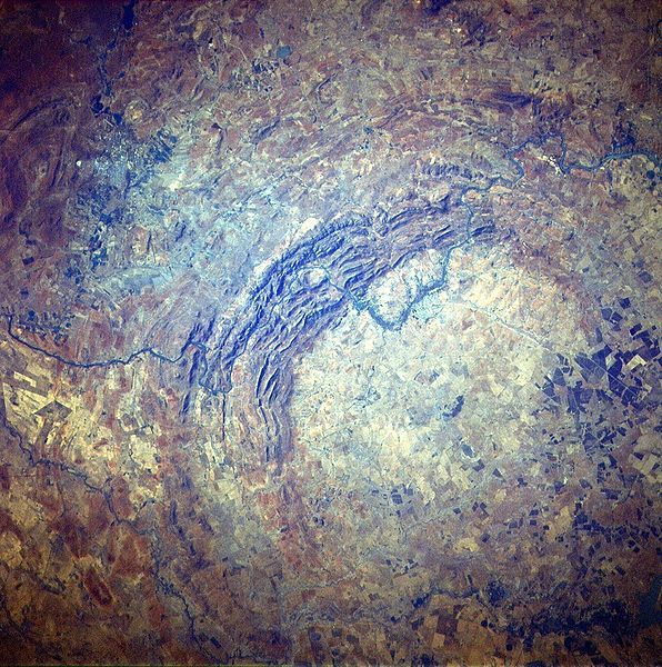 2,023 Ma * Vredefort Crater 2,023 Ma * Vredefort Crater - South Africa 300 km (Size depends on which rings they include) S 27° 0', E 27° 30' Rich in Gold! 1,850 Ma * Sudbury Crater - Ontario, Canada 250km. N 46° 36', W 81° 11' Rich in Nickle! Compare them to the * Chelyabinsk meteorite that recently (February 15, 2013) injured over a thousand people and punched a 20 yard wide hole in a Russian lake. 300 km. Try to Imagine that! 186.3 miles in diameter. That is HUGE, covering over 27,246 Square miles . That is larger than the entire state of West Virginia! And it was only one among many. What did those early huge impacts do to move our continental plates around? Imagine a piston that large pressing at 72 km/sec on the liquid core of the earth! Liquids do not compress. That energy would be instantly pressed against the entire crust of the earth. Every weak point would fail, and the surface would be flooded with wave after wave of basalt. 1,800 Ma * Paasselkä Finland 10 Km N 62° 2', E 29° 5' 1,700 - 2,100 Ma * Dhala India 11 km N 25°17' 59.7", E 78°8' 3.1" 1,630? Ma * Shoemaker Western Australia, Australia 30 km 25̊52'S 120̊53'E 1,402 Ma * Matt Wilson Northern Territory 7.5 km S 15° 30', E 131° 11' 1,400-1,500 Ma * Keurusselkä, Western Finland, Finland 10-30 km 62̊8'N 24̊36'E 1,400 Ma * Goyder Northern Territory 3 km S 13° 28', E 135° 2' 1,270 Ma ~ The Coppermine River Group (Canada) part of the larger Mackenzie Large Igneous Province (One of the known flood volcano events during the Mesoproterozoic) Coppermine River Group From Wikipedia, the free encyclopedia 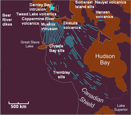 Mackenzie_Large_Igneous_Province.png Map of the Mackenzie Large Igneous Province and its sub-features. The Coppermine River Group are shown as "Coppermine River volcanics". The Coppermine River Group is a sequence of Mesoproterozoic continental flood basalts forming part of the Mackenzie Large Igneous Province in the Northwest Territories and Nunavut, Canada. It is among the largest flood basalt province on Earth, covering the area with a volume of approximately 650,000 km3 (155,943 cu mi). Eruptive history The Coppermine River Group was formed when vast volumes of basaltic lava paved over a large area of the northwestern Canadian Shield about 1,267 million years ago. These basalts form flood basalts that reach thicknesses ranging from 2,000 m (6,562 ft) to 3,500 m (11,483 ft) and consists of about 150 lava flows, each about 10-25 m thick. Except for the lowermost flows, which contain evidence of interaction with water, the entire sequence was erupted subaerially. Eruption of plateau lavas near the Coppermine River, built an extensive volcanic plateau about 1,200 million years ago with an area of about 170,000 km2 (65,637 sq mi) representing a volume of lavas of at least 500,000 km3 (119,956 cu mi). These flood basalts have been interpreted as contemporaneous with the giant Mackenzie dike swarm and with the Muskox intrusion 1,200 Ma * Santa Fe New Mexico , U.S.A. 6-13 km N 35° 45', W 105° 56' 1,180 Ma * Duluth Crater USA - 200km Earth experienced a period of continental joining of all the major landmasses into the huge super continent of Rodinia just prior to the beginning of the Neoproterozoic.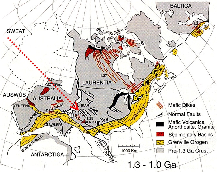 1,000 Ma * 1,000 Ma * 3 Craters Finland series -3km, 4km, 9km Rodinia was fully assembled by one billion years ago and rivaled the future Pangea in size.Before the beginning of the Cambrian, Rodinia split in half, resulting in the creation of the Pacific Ocean west of what would become North America.
The tectonic events involved in the breakup of Rodinia and melting of the Varanger glaciers changed the ocean basins and flooded portions of many continents.800 – 635 Ma Cryogenian (or Sturtian-Varangian) Ice Age Cryogenian Neoproterozoic Era The second ice age, and possibly most severe, is estimated to have occurred from 850 to 635 Ma in the late Proterozoic Age and it has been suggested that it produced a second "Snowball Earth" in which the earth iced over completely. 700 Ma * Jänisjärvi Russia 14 km N 61° 58', E 30° 55' 700 - 580 Ma The Mozambique ocean began closing between Madagascar-India and the Congo-Tanzania cratons. Closure was between 600 and 500 million years ago, initiating the Pan-African orogeny, a series of major Neoproterozoic mountain building events as continental plates came together along the Mozambique Belt. It extended from east Antarctica through East Africa up to the Arabian-Nubian Shield and formed the supercontinents Gondwana and Pannotia. Angular unconformities and an intercontinental volcanic chain of andesite and rhyolite lavas dated to the Ediacaran period give ample evidence of the compression event. A major volcanic episode recorded the Neoproterozoic-Cambrian transition in the Moroccan Anti-Atlas where the Boho Jbel and several other volcanic cones are still preserved in the El Graara massif with volcanic flows dated as Early Cambrian (U/Pb date of 534.10Ma). In the southern Moroccan Atlas, abundant volcanic and sedimentary formations, dated from the Ediacaran to Cambrian time, were set at the northwestern Paleo-Gondwanan margin, after the main Pan-African orogenic event. 646 Ma * Strangways Northern Territory, Australia 25 km 15̊12'S 133̊35'E 600-1660 Ma * Amelia Creek, Northern Territory, Australia 20 km 20̊55'S 134̊50'E 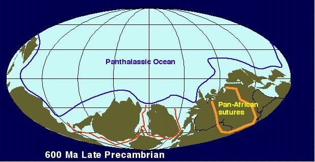 635-542 Ma The Ediacaran Period 635-542 Ma The Ediacaran Period is the time from the end of global Marinoan glaciation to the first appearance worldwide of trace fossils (Treptichnus pedum). During the Ediacaran period two main groups of organisms are found in the fossil record: the "Ediacara biota" of soft-bodied organisms preserved by microbial mats, and carbonate skeletons of Cloudina and Namacalathus. It’s beginning is defined by a chemically distinctive carbonate layer that is referred to as a "cap carbonate", because it caps glacial deposits indicating a sudden climatic change at the end of the Marinoan ice age. :?: Why did the world warm up? 600 Ma * Saarijärvi Finland 1.5 km N 65° 17', E 28° 23' 600 Ma * Beaverhead Idaho and Montana, United States 60 km 44̊15'N 114̊0'W 600 Ma * Söderfjärden Finland 6.6 km N 63° 2', E 21° 35' 580 Ma * Acraman South Australia, Australia 85-90 km 32̊1'S 135̊27'E 573 Ma * Luizi Democratic Republic of Congo 17 km S 10° 10', E 28° 00' 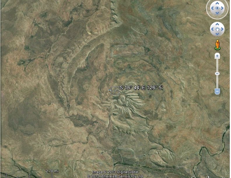 570 Ma * Spider 570 Ma * Spider Western Australia 13 Km S 16° 44', E 126° 5' 560 Ma * Sääksjärvi Finland 6 km N 61° 24', E 22° 24' 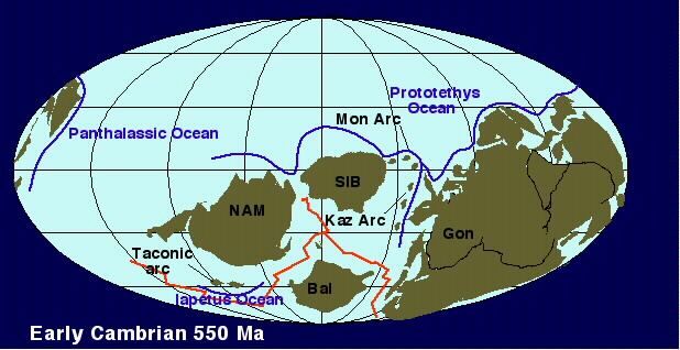 550 Ma * 550 Ma * Kelly West Northern Territory 10 km S 19° 56', E 133° 57' 550 Ma * Holleford Ontario, Canada 2.35 km N 44° 28', W 76° 38' 545 Ma * Foelsche Northern Territory 6 km S 16° 40', E 136° 47' Where early proterozoic rocks are found in Utah they have been under great pressure and changed to schist and GNEISS, pronounced "nice". 542 Ma scarce life forms |
|
|
|
Post by 1dave on Sept 7, 2020 12:31:45 GMT -7
540 Ma Vendian-Ediacaran Time Ends \ Cambrian Time Begins. The Great Unconformity. The Great Unconformity. 1,150 million years of history washed away! www.news.wisc.edu/20576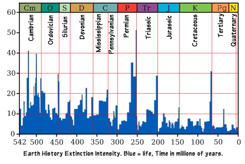 As the chart reveals, The Cambrian was the best of times, and the worst of times. As the chart reveals, The Cambrian was the best of times, and the worst of times. Referred to as the Cambrian explosion, nutrients spurred numerous spurts of life (I suspect a result of the unrecognized Udokan Impact). The 520 Botomian extinction was followed in 510 by the Antrim flood volcanics . Life spurted again only to be beaten back by massive series of impacts in 500. In 490 the Cambrian came to an end.  Early life forms apparently began in, and radiated out from Siberia - and used copper based Hemocyanins to carry oxygen in the bodies of most molluscs, and some arthropods (trilobites, crabs millipedes, insects) instead of using iron like we do. Early life forms apparently began in, and radiated out from Siberia - and used copper based Hemocyanins to carry oxygen in the bodies of most molluscs, and some arthropods (trilobites, crabs millipedes, insects) instead of using iron like we do.Where did the Siberian copper come from? How about the heat to end the ice age? I believe there was an unrecognized ancient impact heavy with copper prior to this event. 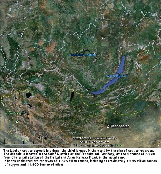 UdokanCopperSiberia.jpg To our present day delight, many Cambrian formations have well preserved fossils indicating burial in an anoxic environment with minimal bacteria that delayed decomposition. The Dresbachian is a regional stage of North American. It is part of the Upper Cambrian and is defined by four trilobite zones still involved in naming wars: 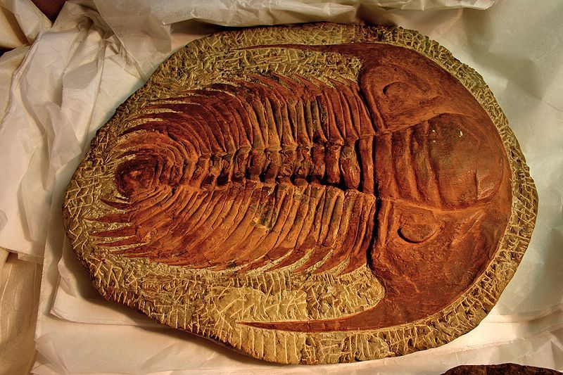 redlichiid Paradoxides_sp 542 to 521 Ma = Series 1
536 Ma First molluscs, hyoliths with small conical shells, halkieriids and other SSF (small shelly fauna) appear. 530 Ma SSF diversification, first brachiopods & archaeocyatha appear521 Ma First Trilobites : fallotaspids, and redlichiids (both order Redlichiida) and bigotinids (order Ptychopariida, superfamily Ellipsocephaloidea) dated to some 540 to 520 million years ago. Contenders for the earliest trilobites include Profallotaspis jakutensis (Siberia), Fritzaspis sp. (western USA), Hupetina antiqua (Morocco) and Serrania gordaensis (Spain). All trilobites are thought to have originated in present day Siberia, with subsequent distribution and radiation from this location. Over 17,000 species of Trilobites are known! 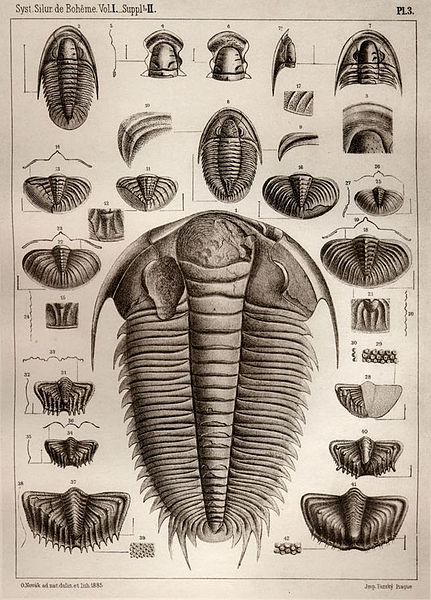 Plate from Joachim Barrande's work Système silurien du centre de la Bohême 521 to 510 Ma = Series 2 olenelloid trilobites520 Ma * Ritland Norway 2.7 km N 59° 14', E 6° 26' 517 Ma End of the Botomian extinction event caused by shortage of oxygen in the water which aided fossil preservation because their scavengers died too. 516 Ma Archaeocyatha “Ancient Cups” Reef building marine creatures extinction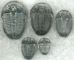 Trilobites we collect west of Delta. They are hard and are often placed in rings and other jewelry. 515 Ma * Lawn Hill Queensland 18 km S 18° 40', E 138° 39' 510 to 501 Ma = Series 3Antrim flood volcanics. 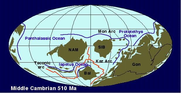 510_1st.jpg 508 Ma * Glikson Australia 19 km S 23° 59', E 121° 34' 505 Ma * Rock Elm Wisconsin, U.S.A. 6 km N 44° 43', W 92° 14' 505 Ma The famous Burgess Shale was laid down502 Ma Dresbachian extinction501 to 488.3 Ma = Furongian SeriesThen came the impacts. 500 Ma * Mizarai Lithuania 5 km N 54° 1', E 23° 54' 500 Ma * Gardnos Norway 5 km N 60° 39', E 9° 0' 500 Ma * Glover Bluff Wisconsin, U.S.A. 8 km N 43° 58', W 89° 32' 500 Ma * Newporte North Dakota, U.S.A. 3.2 km N 48° 58', W 101° 58' 500 Ma * Presqu'ile Quebec, Canada 24 km N 49° 43', W 74° 48' www.trilobites.info/biostratigraphy.htm (If you are interested in the Cambrian, A MUST SEE Website!) The fossil record of the earliest Cambrian, just after the Ediacaran period, shows a sudden increase in burrowing activity and diversity. However, the Cambrian explosion of animals that gave rise to body fossils did not happen instantaneously. The data indicates a radiation of animals to fill in vacant niches, left empty by the extinction of the pre-existing fauna. Sea level reached its maximum during the middle and later parts of the Cambrian. Flooding and erosion combined with elevated temperatures led to increased rates of erosion that altered ocean chemistry. The increase in oxygen and nutrient content of seawater set the stage for the “Cambrian explosion” of life.By the middle and later parts of the Cambrian, continued rifting had sent the paleocontinents of Laurentia (made up of present-day North America and Greenland), Baltica (made up of present-day western Europe and Scandinavia), and Siberia on their separate ways. Teeming life depleted oxygen in all the oceans and there were few plants to restore it, causing massive die-offs.(Conjecture) New plate collisions led to the formation of Gondwana, a supercontinent composed of what would become Australia, Antarctica, India, Africa, and South America. Life rebounded. The House Range west of Delta Utah has the most complete middle and early Cambrian fossil bearing sequences found anywhere!
|
|
|
|
Post by 1dave on Sept 7, 2020 12:32:44 GMT -7
490 Ma Cambrian time ends\ Ordovician Time begins
Earth and the solar system completed it's 18th journey around the galaxy through the old and 2,260,000 new supernova remnants. 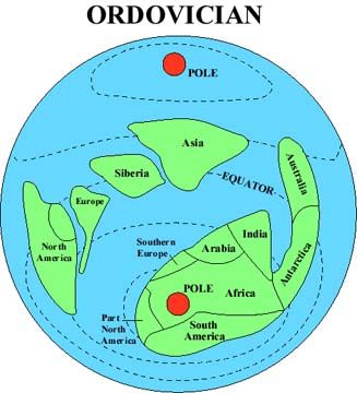 Notice the eastern part of North America was part of Gondwanaland? What does that imply? Rio Grand or Mississippi? 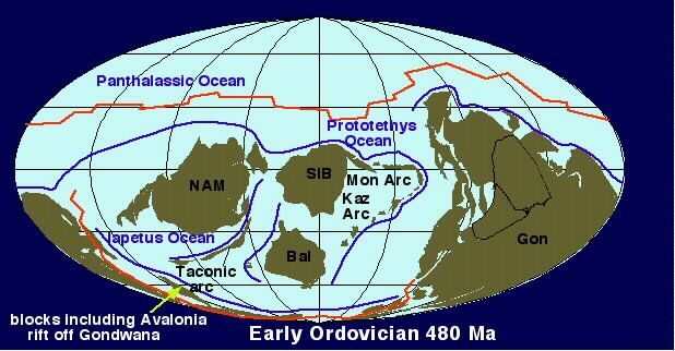 480 Ma The first of several mountain building continental plate collisions forced the birth of the Appalachian ranges and ended in building the supercontinent Pangea with the Appalachians near its center.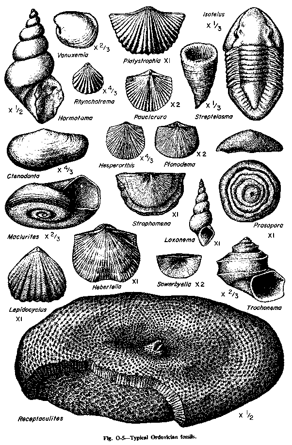 Ordovician-Fossils.gif www.projectexploration.org/blog/wp-content/uploads/2009/08/Ordovician-Fossils.gifWhen Item (* = Impact, ~ = Flood Basalt, ^ = Major Volcanic Eruption)470 Ma * Granby Sweden 3 KM N 58° 25', E 14° 56' 470 Ma * Neugrund Estonia 8 km N 59° 20', E 23° 40' 470 Ma * Ames Oklahoma, U.S.A. 16 km N 36° 15', W 98° 12' 457 Ma ^ two beds in Middle Ordovician rocks, the Deicke bentonite and the Millbrig bentonite, may represent some of the largest explosive volcanic eruptions in the geologic record. It has been estimated that these eruptions generated about 5,000 times the volume of volcanic ash produced by the eruption of Mt. St. Helens in 1980.455 Ma * Kärdla Estonia 4 km N 59° 1', E 22° 46' 455 Ma * Tvären Sweden 2 km N 58° 46', E 17° 25' 455 Ma * Lockne Sweden 7.5 km N 63° 0', E 14° 49' 454 Ma ^ Millbrig eruptions—Bentonites England, exposed in Northern Europe and Eastern US 1,509 km3 One of the oldest large eruptions preserved. These beds have been traced from the Mississippi River eastward across North America and Europe and into Russia.450 ma * Calvin Michigan, USA 8.5 km N 41° 50', W 85° 57' 450 Ma * Slate Islands Ontario, Canada 30 km N 48° 40', W 87° 0' 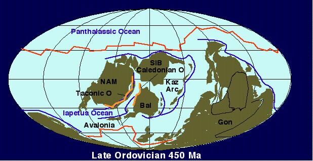 450_1st.jpg 450 – 420 Ma Andean-Saharan Ice Age, Ordovician–Silurian extinction events (or O-S) Three events occurred that killed off 27% of all families, 57% of all genera and 60% to 70% of all species. Together they are ranked by many scientists as the second largest of the five major extinctions in Earth's history, ranking only below the Permian extinction. The continents of Avalonia, Baltica, and Laurentia drifted together near the equator in the Caledonian orogeny, a mountain building collision that extended from New York State through Europe and Greenland to Norway, starting the formation of a second supercontinent known as Euramerica.
|
|
|
|
Post by 1dave on Sept 7, 2020 12:33:47 GMT -7
443 Ma Ordovician Ended / Silurian Time Began.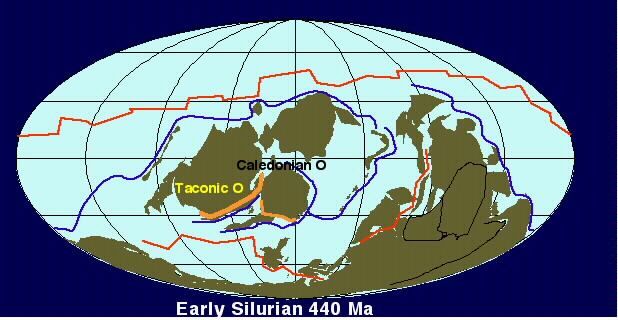 440_1st.jpg 
The Silurian is subdivided into four epochs, each distinguished from the others by the appearance of new species of graptolites. The beginning of the Silurian (and the Llandovery) is marked by the appearance of a species of graptolite, Parakidograptus acuminatus. Graptolites are a group of extinct colonial, aquatic animals that put in their first appearance in the Cambrian Period and persisted into the early Carboniferous. 445 Ma * Pilot Northwest Territories, Canada 6 km N 60° 17', W 111° 1' 443.7-428.2 Ma The Llandovery Epoch fossils are preserved in shale, sandstone, and gray mudstone sediment. Its beginning is the appearance of the graptolites Parakidograptus acuminatus and Akidograptus ascensus. The Llandoverian epoch is subdivided into the Rhuddanian, Aeronian, and Telychian stages. 433 Ma The Ireviken event began in the ocean depths, and made its way into the shallower shelf seas where shallow-water reefs were barely affected. Organisms such as the graptolites, over 50% of trilobite species, and 80% of conodont species went extinct. Most likely cause = Deep-ocean anoxia. 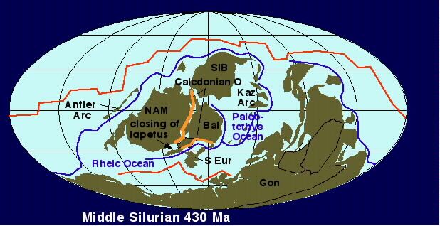 430_1st.jpg 430 Ma * Couture Quebec, Canada 8 km N 60° 8', W 75° 20' 430 Ma * Glasford Illinois, U.S.A. 4 km N 40° 36', W 89° 47' 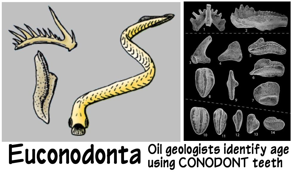 428 - 423 Ma the Wenlockian epoch 428 - 423 Ma the Wenlockian epoch begins with the appearance of Cyrtograptus centrifugus fossils found in siltstone and mudstone under limestone. Missing from the fossil record of the Wenlock was the conodont Pterospathodus amorphognathoides, present in earlier strata. This is an epoch with excellent preservations of brachiopod, coral, trilobite, clam, bryozoan, and crinoid fossils. The Wenlock is subdivided into the Sheinwoodian and Homerian stages. During the Wenlock the first plants and animals appeared on land! 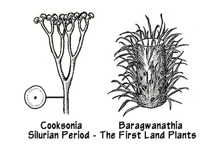 SilurianFirstPlants.jpg For more about early land plants, visit the Virtual Paleobotany Lab: www.ucmp.berkeley.edu/IB181/VPL/Dir.html424 Ma The Mulde event, the second of three extinction events during the Silurian period coincided with a global drop in sea level possibly related to glaciation. 423 - 418 Ma The Ludlow Epoch consists of siltstone and limestone strata, marked by the appearance of Neodiversograptus nilssoni. There is an abundance of shelly animal fossils. The Gorstian and Ludfordian stages make up the Ludlow epoch. 420 Ma The Lau event was the last of three extinctions during the Silurian period, having a major effect on conodont fauna, but practically none on graptolites. It coincided with a global low point in sea level which may have increased ocean salinity. Restricted sea circulation during the Ludlow and Pridoli times initiated massive deposition of salt beds in northern Europe, Siberia, South China and Australia. 418 - 416 Ma The Pridolian, the final epoch of the Silurian, is marked by platy limestone layers rich in cephalopods and bivalves, marked by the appearance of the index fossil Monograptus parultimus, and also by two new species of chitinozoans (marine plankton), Urnochitina urna and Fungochitina kosovensis, which appear at the base or just above the base of the Pridoli. 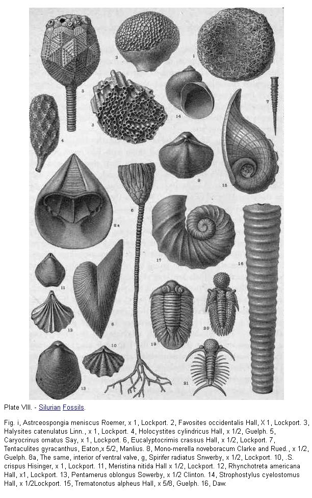 SilurianFossils.JPG 416 Ma End of Silurian Period. Major asteroid site found in Aussie outback Pre-Devonian traps: Volcanic activity suspected but unidentified.
|
|
|
|
Post by 1dave on Sept 7, 2020 12:34:48 GMT -7
417 Ma Silurian end \ Devonian Time Began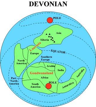  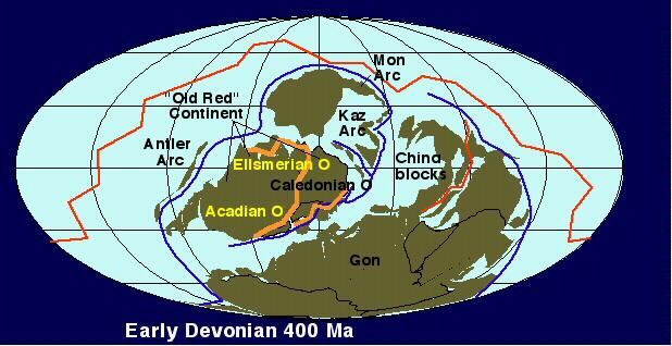 400_1st.jpg When Item (* = Impact, ~ = Flood Basalt, ^ = Major Volcanic Eruption)400 Ma * La Moinerie Quebec, Canada 8 km N 57° 26', W 66° 37' 400 Ma * Nicholson Northwest Territories, Canada 12.5 km N 62° 40', W 102° 41' 396 Ma * Brent Ontario, Canada 3.8 km N 46° 5', W 78° 29' 395 Ma * Elbow Saskatchewan, Canada 8 km N 50° 59', W 106° 43' 380 Ma * Kaluga Russia 15 km N 54° 30', E 36° 12' 378 Ma * Ilyinets Ukraine 8.5 km N 49° 7', E 29° 6' 377 Ma * Siljan Sweden 52 km N 61° 2', E 14° 52' 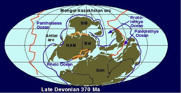 370_1st.jpg 364 Ma * Woodleigh Western Australia 40 km S 26° 3', E 114° 39' 360 Ma * Flynn Creek Tennessee, U.S.A. 3.8 km N 36° 17', W 85° 40' 360 Ma * Piccaninny Western Australia 7 km S 17° 32', E 128° 25' 360-375? Ma * Tai Lake Tai, China 68.5 km 31̊2'N 120̊2'E 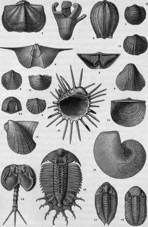 Plate-IX-Devonian-Fossils.jpg Plate IX. - Devonian Fossils. Fig. i, Edriocrinus sacculus Hall, x 1/2, Oriskany. 2, Nucleocrintis verneuli Troost, x 1, Onondaga. 3, Sprifer macropleurus Conr , X 1/2, Helderberg. 4, S. disjunctus Sowerby, x 1/2; internal cast of ventral valve, Chemung. 5, S. mucronatus Conr., x 1/2; inner view of dorsal valve, showing arm-supports, Hamilton. 6, Vitulina pustulosa Hall, x 3/2,, Hamilton. 7, Atrypa reticularis Linn., x 1/2, Hamilton. 8, Hypothyris venustula Half, x 5/8, Tully. 8 a, The same, anterior view. 9, Gypidula galeata Dalman, x 1/2 kinds of flowering plants in the Gymnosperms, which presumably grew upon the higher lands Read more: chestofbooks.com/science/geology/Intro/Devonian-Life.html#.UT0mszcQdPw#ixzz2NBeyqSzKDevonian rocks are thick in western Utah.
|
|
|
|
Post by 1dave on Sept 7, 2020 12:35:50 GMT -7
360 Ma Devonian ended \ Mississippian Time Began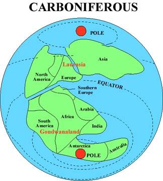 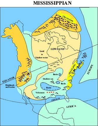 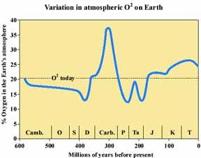 With plant life expanding on land, the oxygen levels went way up! Terrestrial life was well established by the Carboniferous period, now divided into two periods, the earliest and longest was the Mississippian. Amphibians were the dominant land vertebrates, of which one branch would eventually evolve into reptiles, the first fully terrestrial vertebrates. Arthropods were also very common, and many were much larger than those of today. Vast swaths of forest covered the land, which would eventually become the coal beds characteristic of the Carboniferous system. A minor marine and terrestrial extinction event occurred in the last third of the period, leaving numerous “sedimentary geodes”scattered throughout the lake bottoms. Whatever killed all those creatures also killed their scavengers, so they were preserved. 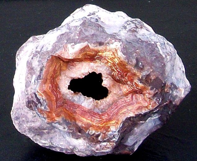 Sedimentary Geode - Dryhead 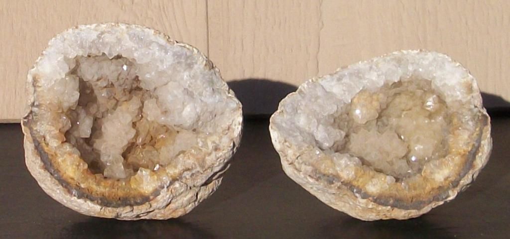 sedimentary Geode - Keokuk The last part of the period, known as the Pennsylvanian, experienced mountain building, glaciation, and low sea level as the continents collided to form Pangaea. Due to the large thickness of coal and oil bearing deposits with Pennsylvanian ages in Europe and North America, the two sub-periods were long thought to have been more or less equal. 351 ± 20 Ma * West Hawk, Manitoba, Canada, 2.44 Km N 49̊ 46', W 95̊ 11' < 345 Ma * Aorounga, Chad, 12.6 km, N 19̊ 6', E 19̊ 15' < 345 Ma * Gweni-Fada, Chad, 14 km, N 17̊ 25', E 21̊ 45' 342 ± 15 Ma * Charlevoix, Quebec, Canada 54 km, N 47̊ 32', W 70̊ 18' 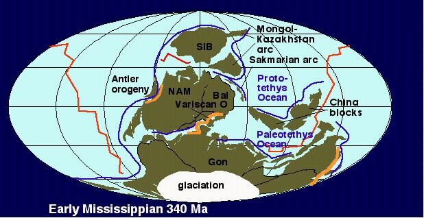 340_1st.jpg 320 ± 80 Ma * Crooked Creek, Missouri, U.S.A. 7 km, N 37̊ 50', W 91̊ 23' < 320 Ma * Serpent Mound, Ohio, U.S.A. 8 km, N 39̊ 2', W 83̊ 24' 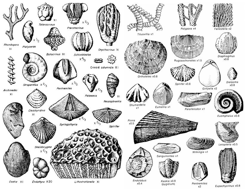 fossil_mississippian.jpg
|
|
|
|
Post by 1dave on Sept 7, 2020 12:37:05 GMT -7
 314 Ma Mississippian time ended \ Pennsylvanian time began 314 Ma Mississippian time ended \ Pennsylvanian time began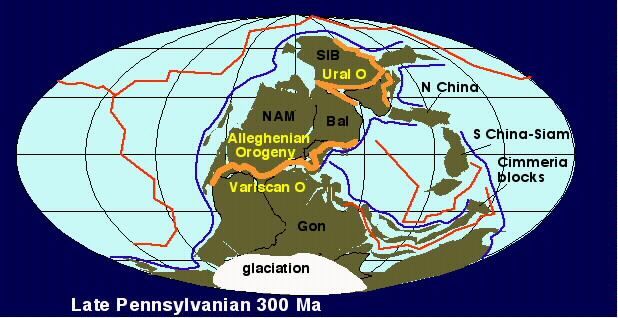 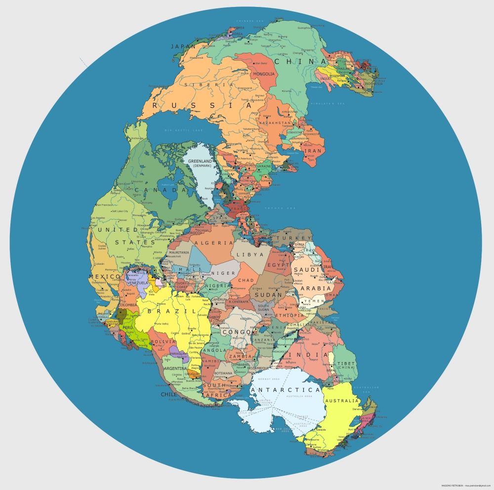 Not accurate, but provides a guess on where things came from. And the impacts continued. 300 ± 50 Ma * Mishina Gora, Russia, 2.5 km, N 58̊ 43', E 28̊ 3' 300 Ma * Decaturville, Missouri, U.S.A. 6 km, N 37̊ 54', W 92̊ 43' 300 Ma * Ile Rouleau, Quebec, Canada 4 km, N 50̊ 41', W 73̊ 53' 300 Ma * Middlesboro, Kentucky, U.S.A. 6 km, N 36̊ 37', W 83̊ 44' 300 Ma * Serra da Cangalha, Brazil, 12 km, S 8̊ 5', W 46̊ 52'  Serra da Cangalha, Brazil, 12 Km  penfos.gif |
|
|
|
Post by 1dave on Sept 7, 2020 12:38:07 GMT -7
290Ma Pennsylvanian time ended \ Permian time began290 ± 35 Ma * Dobele, Latvia, 4.5 km, N 56̊ 35', E 23̊ 15' 290 ± 20 Ma * Clearwater West, Quebec, Canada, 36 km, N 56̊ 13', W 74̊ 30'  East & West 290 ± 20 Ma * Clearwater East, Quebec, Canada, 26 km, N 56̊ 5', W 74̊ 7' 280 ± 10 Ma * Ternovka, Ukraine, 11 km, N 48̊ 08', E 33̊ 31' < 280 Ma * Des Plaines, Illinois, U.S.A. 8 km, N 42̊ 3', W 87̊ 52' 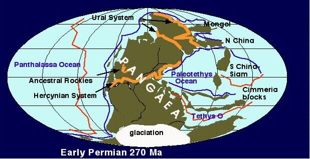 270_1st.jpg The Permian was one of the greatest times of advances, diversity, and flourishing of life forms on land and in the sea. It ended with the greatest catastrophe and destruction of life of all times. 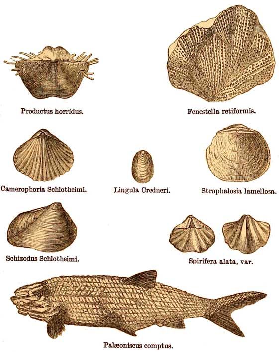  Amphibian.jpg 254.7 ± 2.5 Ma * Araguainha, Brazil, 40 km, S 16̊ 47', W 52̊ 59' 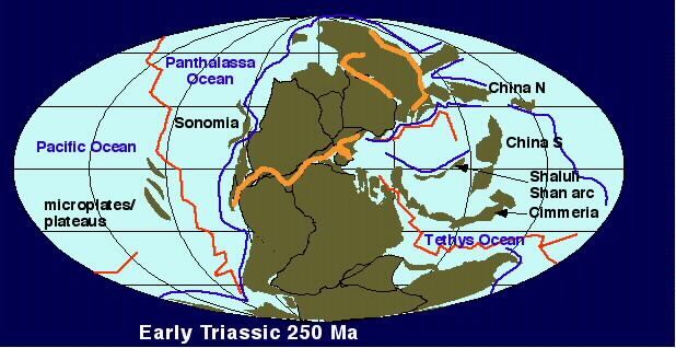 250_1st.jpg 250 Ma * Wilkes Land, Antartica 500 Km 251 Ma ~ Siberian Traps (Russia) (end of Permian) The Siberian Traps form a large region of volcanic rock, known as a Large Igneous Province (LIP), in Siberia, Russia. The massive eruptive event which formed the traps, one of the largest known volcanic events of the last 500 million years of Earth's geological history, continued for a million years and spanned the Permian–Triassic boundary, about 251 to 250 million years ago. Vast volumes of basaltic lava paved over a large expanse of primeval Siberia in a flood basalt event. Today the area covered is about 2 million km2—roughly equal to western Europe in land area—and estimates of the original coverage are as high as 7 million km2. The original volume of lava is estimated to range from 1 million to 4 million km3. 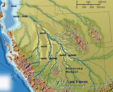 This was when the first giant trees were buried in the Shinirump formation at the base of the Painted Desert of Nevada, Utah, and Arizona. This was 25 million years before the Chinle Petrified Forest was buried in a similar manner.
|
|
|
|
Post by 1dave on Sept 7, 2020 12:39:23 GMT -7
251Ma Permian time ends \ Triassic time beginsEarth and the solar system completed it's 19th journey around the galaxy.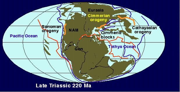 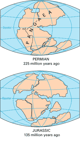 250 ± 80 Ma * K ursk, Russia, 6 km, N 51̊ 42', E 36̊ 0' < 250 Ma * Gow, Saskatchewan, Canada, 5 km, N 56̊ 27', W 104̊ 29' ~ 230 Ma * Karikkoselkä, Finland, 1.5 km, N 62̊ 13', E 25̊ 15'   This was the time when the giant trees were buried at the top of the Painted Desert in the Petrified Forrest National Park in Arizona, but actually stretching from Nevada to Texas.  220 ± 32 Ma * Saint Martin, Manitoba, Canada, 40 km, N 51̊ 47', W 98̊ 32'  Saint Martin, Manitoba, Canada, 40 Km. 214 ± 1 Ma * Manicouagan, Quebec,Canada, 85 km, N 51̊ 23', W 68̊ 42'  Shuttle Image STS-100 332-011 - Manicouagan with International Space Station April, 2001 - submitted by Chuck Simonds
|
|
|
|
Post by 1dave on Sept 7, 2020 12:40:28 GMT -7
206Ma Triassic time ends \Jurassic time begins205 Ma Triassic-Jurassic Mass Extinction Event: About half of the species on Earth were wiped out. 20% of marine families and 55% of marine genera, and 70% to 75% of all species went extinct, including non-dinosaurian archosaurs (other than crocodiles). Some therapids, and most of the large amphibians and mammal-like creatures were eliminated. Around 80% of all land quadrupeds also went extinct. With most of their competition having been wiped out, the reign of the dinosaurs officially began. Non-dinosaurian archosaurs continued to dominate aquatic environments, while non-archosaurian diapsids continued to dominate marine environments. This event happened in less than 10,000 years, just before the supercontinent Pangea began to break apart. There are several theories as to why this extinction happened, but nothing has been concretely found to determine the exact cause. The leading theories are gradual climate change, sea-level fluctuations, pulse of ocean acidity, massive volcanic eruptions (specifically from the Central Atlantic Magmatic Province, or CAMP), or asteroid impact though a telltale crater has yet to be found. The compounding of an asteroid impact triggering the massive floods of CAMP lava and initiating the breakup of Pangea may explain the Triassic-Jurassic extinction. * Asteroid Impacts, Hot Spots, ~ Flood Basalts, ^ Volcanic Eruptions, Glaciation.201 ± 2 Ma * Rochechouart, France, 23 km, N 45° 50', E 0° 56' 200 ± 100 Ma * Wells Creek, Tennessee, U.S.A. 12 km, N 36° 23', W 87° 40' 200 ± 25 Ma * Red Wing, North Dakota, U.S.A. 9 km, N 47° 36', W 103° 33' 201 Ma Central Atlantic Magmatic ProvinceThe Central Atlantic magmatic province ( CAMP) is a large connected magma flow that formed during the breakup of Pangaea in the Mesozoic Era, near the end of the Triassic and the beginning of the Jurassic. The breakup of Pangaea formed the Atlantic Ocean and provided a heritage of basaltic dikes, sills, and lavas over a vast area around the present central North Atlantic Ocean as well as large deposits in northwest Africa, southwest Europe, as well as northeast South and southeast North America (found as continental thoeliitic basalts in subaerial flows and intrusive bodies). The CAMP volcanic eruptions occurred about 201 million years ago and split into four pulses lasting for over ~600,000 years. The resulting large igneous province is, in area covered, the most extensive on earth. The volume of magma flow of ~2–3 × 10⁶ km3 makes it one of the most voluminous as well. This geologic event is associated with the Triassic–Jurassic extinction event.200 Ma The Great Meteor (New England) Hot Spot began.“In the Atlantic, one of the longest hot spot tracks is the Great Meteor, or New England hot spot, located at 28ºW, 33ºN. It formed the New England seamount chain and the magma intrusions of the White Mountains. Two hundred million years ago (early Mesozoic age), just as the Atlantic was beginning to form, the area northwest of Hudson Bay was over the Great Meteor hot spot. Fifty million years later, as the Atlantic opened slightly, the hot spot track was under present-day Ontario. By 124 to 100 million years ago, the continental area of New Hampshire pushed over the hot spot, and the magma intrusions formed the White Mountains. Finally, between 100 and 80 million years ago, the hot spot formed the New England seamount chain. Bear Seamount—the oldest—formed about 100 to 103 million years ago. Moving southeasterly along the chain, the seamounts get progressively younger, with the Nashville Seamount being about 83 million years old. During the formation of the New England Seamount chain, the oceanic crust (itself only 120 to 80 million years old) pushes over the hot spot at a rate of about 4.7 cm per year. Finally, 80 million years ago, the mid-Atlantic Ridge migrated to the west over the plume. The track of this hot spot then continues on the African Plate and is found today at the Great Meteor Seamount.” oceanexplorer.noaa.gov/explorations/03mountains/background/geology/geology.html * Asteroid Impacts, Hot Spots, ~ Flood Basalts, ^ Volcanic Eruptions, Glaciation. < 200 Ma * Riachão Ring, Brazil, 4.5 km, S 7° 43', W 46° 39' 190 ± 30 Ma * Cloud Creek, Wyoming, USA 7 km, N 43° 7', W 106° 45' 190 ± 20 Ma * Viewfield, Saskatchewan, Canada 2.5 km, N 49° 35', W 103° 4'  < 180 Ma * Kgagodi, Botswana, 3.5 km, S 22° 29', E 27° 35' < 170 Ma * Upheaval Dome, Utah, U.S.A. 10 km, N 38° 26', W 109° 54' 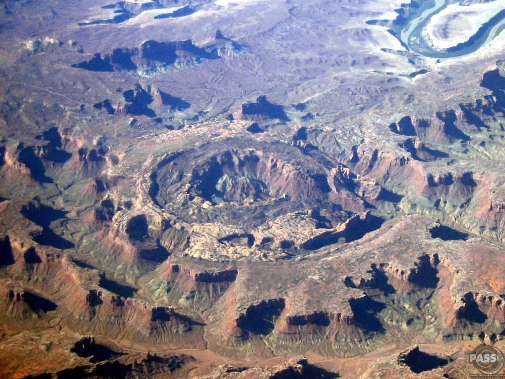 Upheaval Dome 10 Km Diameter - West of Moab, Utah 169 ± 7 Ma * Obolon', Ukraine 20 km, N 49° 35', E 32° 55' 167 ± 3 Ma * Puchezh-Katunki, Russia 40 km, N 56° 58', E 43° 43' 165 ± 5Ma * Zapadnaya, Ukraine 3.2 km, N 49° 44', E 29° 0' > 160 ± 10 Ma * Vepriai, Lithuania 8 km, N 55° 5', E 24° 35' 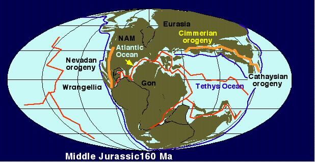 150 ± 70 Ma * Liverpool, Northern Territory 1.6 km, S 12° 24', E 134° 3' 150 ± 20 Ma * Tabun-Khara-Obo, Mongolia 1.3 km, N 44° 07', E 109° 39' 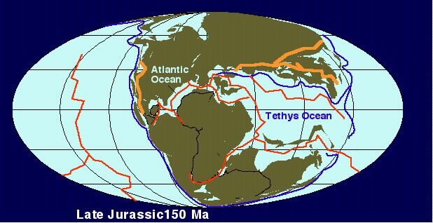 145.0 ± 0.8 Ma * Morokweng, South Africa 70 km, S 26° 28', E 23° 32' 7th largest known crater. 145 Ma The St. Helena hotspot is one the oldest known hotspots on Earth. Located in the southern Atlantic, is responsible for the island of St. Helena and the St. Helena Seamount chain.
|
|
|
|
Post by 1dave on Sept 7, 2020 12:41:32 GMT -7
144Ma Jurassic time ended \ Cretaceous time began * Asteroid Impacts, Hot Spots, ~ Flood Basalts, ^ Volcanic Eruptions, Glaciation.142.5 ± 0.8 Ma * Gosses Bluff, Northern Territory 22 km, S 23° 49', E 132° 19' 142.0 ± 2.6 Ma * Mjølnir, Norway 40 km, N 73° 48', E 29° 40' 138 Ma ~ Karoo and Ferrar provinces (South Africa-Antarctica) Karoo and Ferrar denote a major geologic province consisting of flood basalt, which mostly covers South Africa and Antarctica, although portions extend further into southern Africa and into South America, India, Australia and New Zealand. It formed just prior to the breakup of Gondwana in the Lower Jurassic epoch, about 183 million years ago; this timing corresponds to the early Toarcian anoxic event and the Pliensbachian-Toarcian extinction. The total original volume of the flow, which extends over a distance in excess of 6000 km (4000 km in Antarctica alone), was in excess of 2.5 x 10⁶ km³. 132 Ma Paraná and Etendeka traps (Brazil-Namibia)The Paraná-Etendeka traps (or Paraná and Etendeka Plateau; or Paraná and Etendeka Province) comprise a large igneous province which includes both the main Paraná traps (in Paraná Basin, a South American Geological basin) as well as the smaller severed portions of the flood basalts at the Etendeka traps (in northwest Namibia and southwest Angola). The original basalt flows occurred 128 to 138 million years ago. The province had a post-flow surface area of 1.5 x 10⁶ km² and an original volume projected to be in excess of 2.3 x 10⁶ km³.[1][2] The basalt samples at Paraná and Etendeka have an age of about 132 Ma.[3] Indirectly, the rifting and extension are probably the origin of the Paraná and Etendeka traps and it could be the origin of the Gough and Tristan da Cunha Islands as well, as they are connected by the Walvis Ridge (Gough/Tristan hotspot). The seamounts of the Rio Grande Rise (25°S to 35°S) go eastwards from the Paraná side[4][5] and in 2013 were assessed as being part of the traps system following recovery of samples.[6] Sources are still unclear, however, as to whether this site has been the subject of what may have been the single largest explosive volcanic eruption in Earth's history 130 Ma The Kerguelen hotspot has produced basaltic lava for about 130 million years and has also produced the Kerguelen Islands, Heard Island, the McDonald Islands, and the Ninetyeast Ridge. 130 Ma Kerguelen PlateauThe Kerguelen Plateau is an underwater volcanic Large Igneous Province (LIP) and also a microcontinent and submerged continent in the southern Indian Ocean. It lies about 3,000 km to the southwest of Australia and is nearly three times the size of Japan. The plateau extends for more than 2,200 km in a northwest-southeast direction and lies in deep water. The plateau was produced by the Kerguelen hotspot, starting with or following the breakup of Gondwana about 130 million years ago. There is a small portion of the plateau that breaks sea level, forming the Kerguelen Islands plus the Heard and McDonald Islands. Intermittent volcanism continues on the Heard and McDonald Islands. Geographical extent Symmetrically located across the Indian Ocean ridge and due west of Australia is the Broken Ridge underwater volcanic plateau, which at one time was contiguous with the Kerguelen Plateau prior to rifting by the mid-ocean ridge. To the north of Broken Ridge lies the linear Ninety East Ridge which continues almost due north into the Bay of Bengal and is considered to be a hotspot track. Kerguelen microcontinent The formation of the Kerguelen Plateau started with a series of large volcanic eruptions 110 million years ago. The presence of soil layers in the basalt with included charcoal and conglomerate fragments of gneiss indicate that much of the plateau was above sea level as what is termed a microcontinent for three periods between 100 million years ago and 20 million years ago. The so-called Kerguelen microcontinent may have been covered by dense conifer forest in the mid-Cretaceous. It finally sank 20 million years ago and is now 1 to 2 km (0.6 to 1.2 mi) below sea level. >130, <450 Ma * Tunnunik (formerly Prince Albert), Victoria Island, Arctic Canada ~25 km, N 72° 28', W 113° 58' 128 ± 5 Ma * Tookoonooka, Queensland 55 km, S 27° 7', E 142° 50' -10th largest known crater. 125-120 Ma Ontong Java–Manihiki–Hikurangi PlateauThe Ontong Java Plateau is a huge oceanic plateau located in the Pacific Ocean, lying north of the Solomon Islands. The plateau covers an area of approximately 2,000,000 km2 (770,000 sq mi), or roughly the size of Alaska, and reaches a thickness of up to 30 km (19 mi). The plateau is of volcanic origin, composed mostly of flood basalts. Although they are now separated by thousands of kilometres, Manihiki Plateau and Hikurangi Plateau were at the time of their origin part of the same large igneous province, forming the world's largest oceanic plateau. It extruded some 100 million km3 of magma, covering approximately 1% of the Earth's surface, in one of the largest volcanic events on Earth in the last 300 million years.The Ontong Java Plateau was formed 125–120 million years ago possibly by the initial plume-head phase of a mantle plume center called the Louisville hotspot.[3] The timing corresponds roughly to the early Aptian anoxic event in the oceans.Most of the rocks that make up the plateaus have been dated to 125–119 million years ago, in the Lower Cretaceous Epoch, with some secondary volcanism occurring 20–40 million years later, in the Upper Cretaceous Epoch. These plateaus were formed beneath the waters of the Pacific Ocean, and mostly still lie under the sea—although the collision of the Solomon Islands with the Ontong Java Plateau has lifted some of this plateau above sea level on the islands of Makira, Malaita and the northern half of Santa Isabel—along with the smaller islands of Ramos and Ulawa. Several large seamounts arise from the plateau, including the one capped by Ontong Java Atoll.
* Asteroid Impacts, Hot Spots, ~ Flood Basalts, ^ Volcanic Eruptions, Glaciation.123 ±1.4 Ma * Vargeão Dome, Brazil 12 km, S 26° 50', W 52° 07' 121.0 ± 2.3 Ma * Mien, Sweden 9 km, N 56° 25', E 14° 52' 120 Ma Tristan hotspot ,Walvis Ridge began in the southern Atlantic Ocean 120 ± 10 Ma * Rotmistrovka, Ukraine 2.7 km, N 49° 0', E 32° 0' < 120 Ma * B.P. Structure, Libya 2 km, N 25° 19', E 24° 20'  B.P. Structure < 120 Ma * Oasis, Libya 18 km, N 24° 35', E 24° 24'  115 ± 10 Ma * Carswell, Saskatchewan, Canada 39 km, N 58° 27', W 109° 30' < 110 Ma * Mount Toondina, South Australia 4 km, S 27° 57', E 135° 22' < 110 Ma * Sierra Madera, Texas, U.S.A. 13 km, N 30° 36', W 102° 55'  Sierra Madera Texas. 99 ± 4 Ma * Deep Bay, Saskatchewan, Canada 13 km, N 56° 24', W 102° 59' < 97 Ma * Kentland, Indiana, U.S.A. 13 km, N 40° 45', W 87° 24'  Kentland, Indiana 95 Ma Caribbean large igneous provinceThe Caribbean large igneous province consists of a major flood basalt, which created this large igneous province. It is the source of the current large eastern Pacific oceanic plateau, of which the Caribbean-Colombian oceanic plateau is the tectonized remnant. The deeper levels of the plateau have been exposed on its margins at the North and South American plates. The volcanism took place between 139 and 69 million years ago, with the majority of activity appearing to lie between 95 and 88 Ma. The plateau volume has been estimated as on the order of 4 x 10⁶ km³. It has been linked to the Galápagos hotspot. 3-95 Ma * Avak, Alaska, U.S.A. 12 km, N 71° 15', W 156° 38' 91 ± 7 Ma * Steen River, Alberta, Canada 25 km, N 59° 30', W 117° 38' 89.0 ± 2.7 Ma * Dellen, Sweden 19 km, N 61° 48', E 16° 48' 85 Ma Hawaiian Hotspot activated. (47 Ma 60 degree bend) 81.0 ± 1.5 Ma * Wetumpka, Alabama, U.S.A. 6.5 km, N 32° 31', W 86° 10' @james NOTE. 80 ± 20 Ma * Zeleny Gai, Ukraine 3.5 km, N 48° 4', E 32° 45' 80 Ma The L ouisville hotspot has produced the Louisville seamount chain, which is one of the longest seamount chains on Earth, stretching some 4,300 km (2,672 mi). 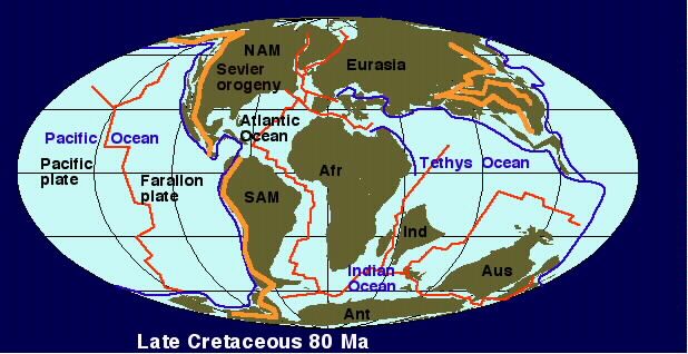 < 75 Ma * Maple Creek, Saskatchewan, Canada 6 km, N 49° 48', W 109° 6' 74.1± 0.1 Ma * Manson, Iowa, U.S.A. 35 km, N 42° 35', W 94° 33' 73.3 ± 5.3 Ma * Lappajärvi, Finland 23 km, N 63° 12', E 23° 42' 70.3 ± 2.2 Ma * Kara, Russia 65 km, N 69° 6', E 64° 9' -8th largest known crater < 70 Ma * Chukcha, Russia 6 km, N 75° 42', E 97° 48' < 70 Ma * Ouarkziz, Algeria 3.5 km, N 29° 0', W 7° 33' < 70 Ma * Tin Bider, Algeria 6 km, N 27° 36', E 5° 7' 66 Ma ~ Deccan Traps (India) 66 million years ago (end of Cretaceous period)The Deccan Traps are a large igneous province located on the Deccan Plateau of west-central India (between 17°–24°N, 73°–74°E) and one of the largest volcanic features on Earth. They consist of multiple layers of solidified flood basalt that together are more than 2,000 m (6,562 ft) thick and cover an area of 500,000 km2 (193,051 sq mi) and a volume of 512,000 km3 (123,000 cu mi). Etymology The Deccan Traps formed between 60 and 68 million years ago, at the end of the Cretaceous period. The bulk of the volcanic eruption occurred at the Western Ghats (near Mumbai) some 66 million years ago. This series of eruptions may have lasted less than 30,000 years in total. The original area covered by the lava flows is estimated to have been as large as 1.5 million km², approximately half the size of modern India. The Deccan Traps region was reduced to its current size by erosion and plate tectonics; the present area of directly observable lava flows is around 512,000 km2 (197,684 sq mi). Effect on climate and contemporary life The release of volcanic gases, particularly sulfur dioxide, during the formation of the traps contributed to contemporary climate change. Data points to an average drop in temperature of 2 °C in this period. Because of its magnitude, scientists formerly speculated that the gases released during the formation of the Deccan Traps played a role in the Cretaceous–Paleogene extinction event (also known as the K–Pg extinction), which included the extinction of the non-avian dinosaurs. Sudden cooling due to sulfurous volcanic gases released by the formation of the traps and localised gas concentrations may have contributed significantly to mass extinctions. However, the current consensus among the scientific community is that the extinction was triggered by the Chicxulub impact event in Central America (which would have produced a sunlight-blocking dust cloud that killed much of the plant life and reduced global temperature, called an impact winter). 66 Ma The Réunion hotspot currently lies under the Island of Réunion in the Indian Ocean. The Chagos-Laccadive Ridge and the southern part of the Mascarene Plateau are volcanic traces of the Réunion hotspot some think responsible for the Deccan traps of India. * Asteroid Impacts, Hot Spots, ~ Flood Basalts, ^ Volcanic Eruptions, Glaciation.65.17 ± 0.64 Ma * Boltysh, Ukraine 24 km, N 48° 45', E 32° 10' < 65 Ma * Eagle Butte, Alberta, Canada 10 km, N 49° 42', W 110° 30' < 65 Ma * Vista Alegre, Brazil 9.5 km, S 25° 57', W 52° 41' 65 Ma * Shiva crater offshore of India 500 km Not officially recognized. 64.98 ± 0.05 Ma * Chicxulub, Yucatan, Mexico 150 km, N 21° 20', W 89° 30' 2nd largest recognized impact crater on earth! Septarion Nodules are jumbled and clumped dead animal remains that were buried in some ancient terrific storms. Those found in Utah were formed in the Frontier Fm of the late Cretaceous. I have noticed still identifiable clam shells etc. Trapped decay gas is most likely what kept the centers open. Body oils seeped into the surrounding mud, making their clumps more cohesive than surrounding mud. Calcite from bones and shells dissolved and re-precipitated several times. 1 stprecipitation is next to the mud. 2 ndprecipitation is darker. 3 rd and later are much lighter in color. 
|
|
|
|
Post by 1dave on Sept 7, 2020 12:42:41 GMT -7
65Ma Cretaceous time ended \ Tertiary time began61 Ma North Atlantic Volcanic Province AKA The Brito-Arctic province, is a major flood basalt province of the North Atlantic Ocean. Basaltic volcanism flowed in two main pulses. The first which occurred ~61 million years ago was of 2 x 10⁶ km³ in total volume, into the current western and southeastern Greenland and northwestern Britain. The second and larger flood basalt flow occurred ~56 Ma in both eastern Greenland and the Faroe Islands.[1] < 60 Ma * Connolly Basin, Western Australia 9 km, S 23° 32', E 124° 45' 58 ± 2 Ma * Marquez, Texas, U.S.A. 12.7 km, N 31° 17', W 96° 18' 56 - 37 Ma * Jebel Waqf as Suwwan, Jordan 5.5 km, N 31° 03', E 36° 48' 50.50 ± 0.76 Ma * Montagnais, Nova Scotia, Canada 45 km, N 42° 53', W 64° 13' < 50 Ma * Goat Paddock, Western Australia 5.1 km, S 18° 20', E 126° 40' 49.0 ± 0.2 Ma * Gusev, Russia 3 km, N 48° 26', E 40° 32' 49.0 ± 0.2 Ma * Kamensk, Russia 25 km, N 48° 21', E 40° 30' 46 ± 7 Ma * Chiyli, Kazakhstan 5.5 km, N 49° 10', E 57° 51' 46 ± 3 Ma * Ragozinka, Russia 9 km, N 58° 44', E 61° 48' 45 ± 10 Ma * Shunak, Kazakhstan 2.8 km, N 47° 12', E 72° 42'  Shunak Kazakhstan 42.3 ± 1.1 Ma * Logoisk, Belarus 15 km, N 54° 12', E 27° 48' 40 ± 20 Ma * Beyenchime-Salaatin, Russia 8 km, N 71° 0', E 121° 40' 40 ± 20 Ma * Logancha, Russia 20 km, N 65° 31', E 95° 56' 39 Ma * Haughton, Nunavut, Canada 23 km, N 75° 22', W 89° 41' 37.2 ± 1.2 Ma * Wanapitei, Ontario, Canada 7.5 km, N 46° 45', W 80° 45' 36.4 ± 4 Ma * Mistastin, Newfoundland/Labrador, Canada 28 km, N 55° 53', W 63° 18' > 35 Ma * Crawford, Australia 8.5 km, S 34° 43', E 139° 2' > 35 Ma * Flaxman, Australia 10 km, S 34° 37', E 139° 4' 35.7 ± 0.2 Ma * Popigai, Russia 90 km, N 71° 39', E 111° 11' -4th/5th largest recognized impact crater. 35.3 ± 0.1 Ma * Chesapeake Bay, Virginia, U.S.A. 40 km, N 37° 17', W 76° 1'  Another impact crater that was fought against tooth and nail by scientists until finally accepting. Another impact crater that was fought against tooth and nail by scientists until finally accepting.30-40 Ma * Rubielos de la Cérida Spain 80x40 km 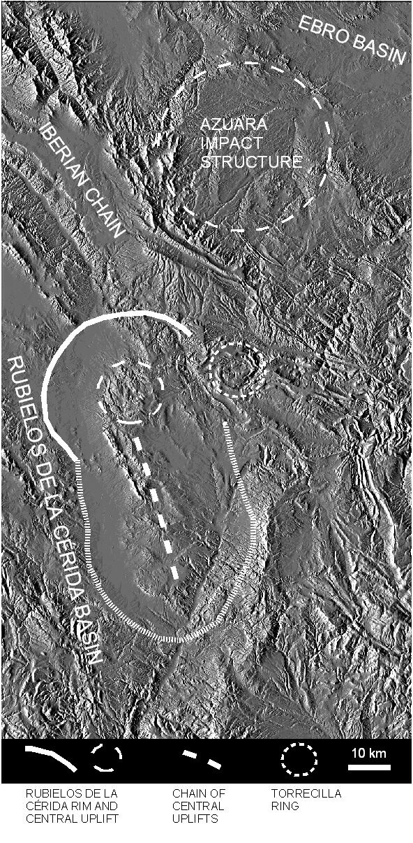 Rubielos de la Cérida Spain 30-40 Ma * Azuara Spain 35-40 km 27 Ma The Cobb–Eickelberg Seamount chain located off the Oregon/Washington coast. 24 Ma The Bowie hotspot began. It is located 180 kilometres (110 mi) west of the Queen Charlotte Islands in the Pacific Ocean and has left a trail of underwater mountains across the Pacific called the Kodiak-Bowie Seamount chain. 16. ============================================================
23 Ma Paleogene \ Neogene - Miocene\ 5 Ma Pliocene * Asteroid Impacts, Hot Spots, ~ Flood Basalts, ^ Volcanic Eruptions, Glaciation. 17-14 Ma Columbia-Snake River flood basaltsThe Columbia River Basalt Group is a large igneous province that lies across parts of the Western United States. It is found in the U.S. states of Washington, Oregon, Idaho, Nevada, and California. The Basalt group includes the Steen and Picture Gorge basalt formations. During late Miocene and early Pliocene epochs, one of the largest flood basalts ever to appear on the Earth's surface engulfed about 163,700 km2 (63,200 sq mi) of the Pacific Northwest, forming a large igneous province with an estimated volume of 174,300 km3 (41,800 cu mi). Eruptions were most vigorous from 17–14 million years ago, when over 99 percent of the basalt was released. Less extensive eruptions continued from 14–6 million years ago.[1] 15.1 ± 0.1 Ma * Ries, Germany 24 km, N 48° 53', E 10° 37' 15 ± 1 Ma * Steinheim, Germany 3.8 km, N 48° 41', E 10° 4'  Steinheim Crater 13 Ma The Anahim hotspot began in central British Columbia, Canada. It is situated on the Interior Plateau, a large region that lies between the Cariboo and Monashee Mountains to the east, and the Hazelton Mountains, Coast Mountains to the west. Identifiable from the mid-Miocene period, it has recorded changes in the western-moving North American Plate because it is believed to have been relatively stationary for tens of millions of years. Since then it has formed a line of volcanoes called the Anahim Volcanic Belt, stretching from the coast to the Interior Plateau near Quesnel.[ 16.5 Ma Yellowstone Hotspot began. 6-10 Ma Chilcotin Group (south-central British Columbia, Canada) The Chilcotin Group, also called the Chilcotin Plateau Basalts, is a large area of basaltic lava that forms a volcanic plateau running parallel with the Garibaldi Volcanic Belt in south-central British Columbia, Canada. Predominantly, during Miocene and Pliocene times, a medium sized volcanic field of overlapping vents occurred in British Columbia's Interior Plateau. The distribution is assumed to engulf up to 50,000 km2 of the Pacific Northwest, forming a medium-sized large igneous province, of volume 3300 km3.[1] Volcanism occurred as late as Oligocene time, but continues sporadically up to present. Eruptions were most vigorous 6-10 million years ago and 2-3 million years ago, when most of the basalt was released. Less extensive eruptions continued 0.01 to 1.6 million years ago >5, <36 Ma * Colônia, Brazil 3.6 km, S 23° 52', W 46° 43'  Colonia, Brazil 5 ± 3 Ma * Bigach, Kazakhstan 8 km, N 48° 34', E 82° 1' 5 ± 1 Ma * Karla, Russia 10 km, N 54° 55', E 48° 2' < 5 Ma * Kara-Kul, Tajikistan 52 km, N 39° 1', E 73° 27' 3.7 ± 0.3 Ma * Roter Kamm, Namibia 2.5 km, S 27° 46', E 16° 18' 3.5 ± 0.5 Ma * El'gygytgyn, Russia 18 km, N 67° 30', E 172° 5' 3.0 ± 0.3 Ma * Aouelloul, Mauritania o.39 km, N 20° 15', W 12° 41' < 3 Ma * Talemzane, Algeria 1.75 km, N 33° 19', E 4° 2'
|
|
|
|
Post by 1dave on Sept 7, 2020 12:46:11 GMT -7
2.6 Ma Neogene ended \ Paleolithic began * Asteroid Impacts, Hot Spots, ~ Flood Basalts, ^ Volcanic Eruptions, Glaciation.1.4 ± 0.1 Ma * New Quebec, Quebec, Canada 3.44 km, N 61° 17', W 73° 40'  New Quebec, Canada 1.07 Ma * Bosumtwi, Ghana 10.5 km, N 6° 30', W 1° 25' < 1 Ma * Monturaqui, Chile 0.46 km, S 23° 56', W 68° 17' < 1 Ma * Veevers, Western Australia 0.08 km, S 22° 58', E 125° 22' Bolide Type IIAB 0.9 ± 0.1 Ma * Zhamanshin, Kazakhstan 14 km, N 48° 24', E 60° 58 Bolide Type Chondrite < 0.3 Ma * Wolfe Creek, Western Australia 0.87 km, S 19° 10', E 127° 48' “ ” IIIAB ~ 0.27 Ma * Dalgaranga, Western Australia 0.02 km, S 27° 38', E 117° 17' Stony Iron 0.250 ± 0.050 Ma * Kalkkop, South Africa 0.64 km, S 32° 43', E 24° 26' 0.220 ± 0.052 Ma * Tswaing, South Africa 1.13 km, S 25° 24', E 28° 5' Chondrite  < 0.1 Ma * Rio Cuarto, Argentina 4.5 km, S 32° 52', W 64° 14' < 0.1 Ma * Amguid, Algeria 0.45 km, N 26° 5', E 4° 23' < 0.0635 Ma * Odessa, Texas, U.S.A. 0.16 km, N 31° 45', W 102° 29' IAB > 0.05 Ma * Xiuyan, China 1.8 km, N 40° 21', E 123° 27' 0.052 ± 0.006 Ma * Lonar, India 1.83 km, N 19° 58', E 76° 31' 0.049 ± 0.003 Ma * Barringer, Arizona, U.S.A. 1.18 km, N 35° 2', W 111° 1' IAB  Barringer, AZ - Thermal infrared image 0.0214 ± 0.0097 Ma * Tenoumer, Mauritania 1.9 km, N 22° 55', W 10° 24' < 0.01 Ma * Morasko, Poland 0.1 km, N 52° 29', E 16° 54' Octahedrite fragments< 0.007 Ma * Macha, Russia 0.3 km, N 60° 6', E 117° 35' Iron ~ 0.0066 Ma * Ilumetsä, Estonia 0.08 km, N 57° 58', E 27° 25' 0.0054± 0.0015 Ma * Boxhole, Northern Territory 0.17 km, S 22° 37', E 135° 12' IIAB 0.0042 ± 0.0019 Ma * Henbury, Northern Territory 0.15 km, S 24° 34', E 133° 8' IIIAB  0.004 ± 0.001 Ma * Kaalijärv, Estonia 0.11 km, N 58° 24', E 22° 40' IAB  Kaalijärv < 0.004 Ma * Campo Del Cielo, Argentina 0.05 km, S 27° 38', W 61° 42' Coarse Octahedrite to Granular Hexahedrite <0.0011 Ma * Whitecourt, Alberta, Canada 0.04 km, N 54° 00', 115° 36' IIIAB iron < 0.001 Ma * Sobolev, Russia 0.05 km, N 46° 18', E 137° 52' Iron < 0.001 Ma * Haviland, Kansas, U.S.A. 0.01 km, N 37° 35', W 99° 10' Pallasite Haaviland Kansas - Pallasites!0.00014 Ma * Wabar, Saudi Arabia 0.11 km, N 21° 30', E 50° 28' IIIAB iron 0.000067 Ma * Sikhote Alin, Russia 0.02 km, N 46° 7', E 134° 40' Hexahedrite 0.000007 Ma * Carancas, Peru 0.0135 km, S 16° 40', W 69° 03' Bolide Type C Fell September 15, 2007!? * Kamil, Egypt 0.045 km, N 22°01', E 26°05'
|
|
|
|
Post by 1dave on Sept 7, 2020 12:47:52 GMT -7
No, I did not. Thank you! They meant "in earth," as it is not stable at our low pressure. |
|
|
|
Post by 1dave on Sept 7, 2020 12:49:15 GMT -7
Organisms are only rarely preserved as fossils in the best of circumstances, and only a fraction of such fossils have been discovered. This is illustrated by the fact that the number of species known through the fossil record is less than 5% of the number of known living species, suggesting that the number of species known through fossils must be far less than 1% of all the species that have ever lived.[27] Because of the specialized and rare circumstances required for a biological structure to fossilize, only a small percentage of life-forms can be expected to be represented in discoveries, and each discovery represents only a snapshot of the process of evolution. The transition itself can only be illustrated and corroborated by transitional fossils, which will never demonstrate an exact half-way point.[28] The fossil record is heavily slanted toward organisms with hard parts, leaving most groups of soft-bodied organisms with little to no role.[27] It is replete with the mollusks, the vertebrates, the echinoderms, the brachiopods and some groups of arthropods.[29] 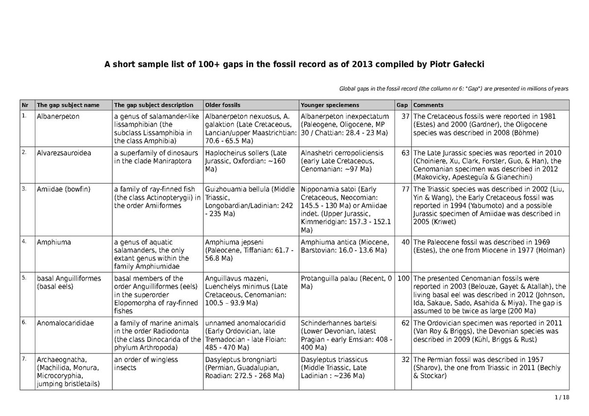
|
|


 More probable to me is the idea that Sol, like most stars, had a partner, but it was drawn out like a string of soap bubbles by a passing massive star. Those "bubbles" became most of our planets.
 Imagine that!
 Were we hit by Mercury? We know it hit something big and lost it’s outer shell.
 300km in Diameter, oldest known surviving crater. Rich in Platinum!