

Post by 1dave on Dec 31, 2020 8:03:59 GMT -7
Thundereggs - AKA lithophysae - are volcanic rocks with a spherulitic structure with concentric chambers and an interior "blown" cavity. Its outer shape is spherical or lenticular. They vary in size from very small up to twelve feet in diameter (Silver Cliff, Colorado) depending on the age of the magma chamber they formed in.

Expansion - Transition from Spheroid to Thunderegg begins as soon as external pressure is released.
Size is dependant on age of the magma. Subduction type volcanoes have a lifespan of several thousands of years BUT HOTSPOTS live for many millions of years!
Eastern Australia passed over a hotspot, leaving a trail of eruptions and lithophysae. the US has passed over at least three.
60 Ma the Siletz1 hotspot suddenly appeared off the west coast of America. From a depth of perhaps 200 - 600 miles super heated mantle material began welling up, spewing basalt that became the huge Siletzia Seamount.
For the next 10 ma siletzia became massive, around 10,000 cubic miles of basalt - about the size of Hawaii!2 This crashed into the Washington/Oregon coast ~50 Ma. As the hotspot moved under the continent, it began melting and spewing limestone from the continental shelf, then as the continent moved over it, silica rocks.
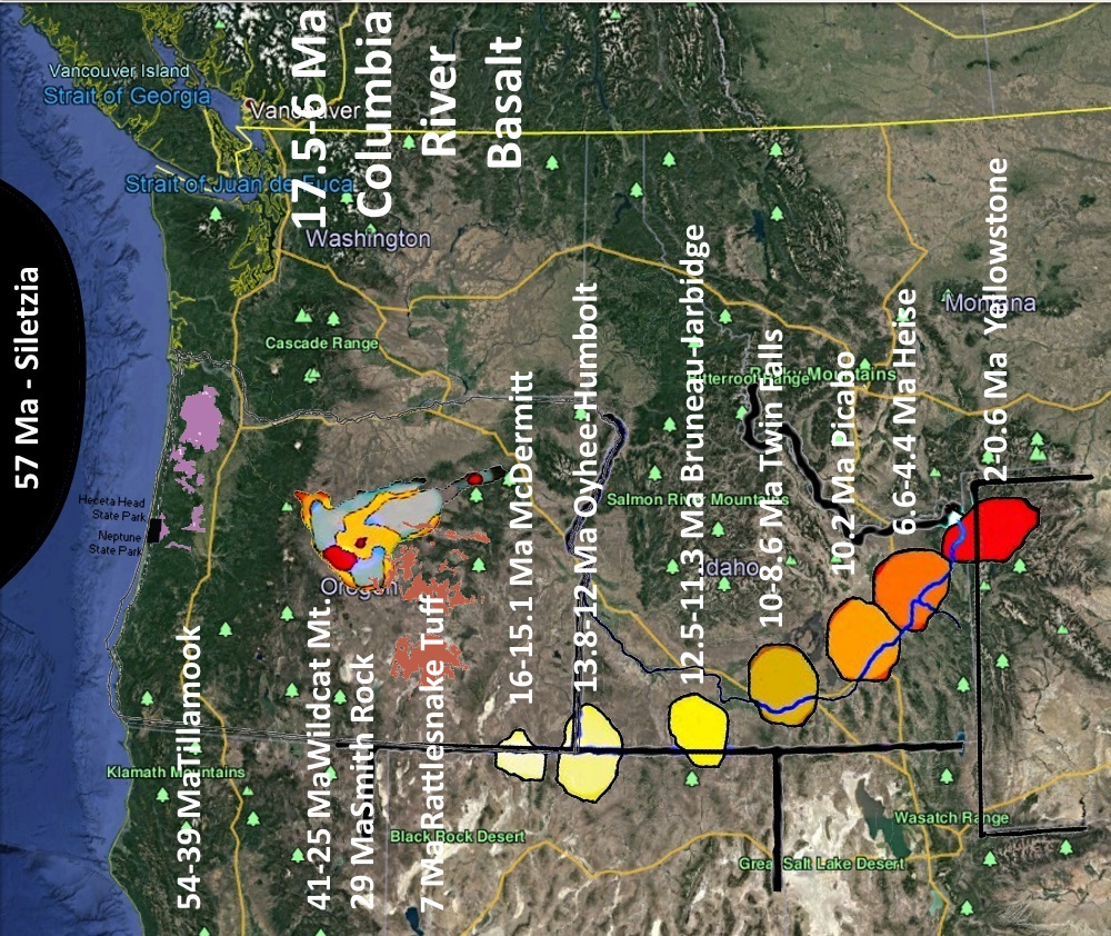
From Siletzia to Yellowstone.
Age - - Name - - State - Volume
57-50 Ma Siletzia Oregon 10,000 Cu. Mi.
54-39 Ma Tillamook Oregon
41-25 Ma Wildcat Mt. Oregon
29 Ma Smith Rock Oregon
13-10 Ma Crooked River Oregon
16-15.1 Ma McDermitt Oregon/Idaho
13.8-12 Ma Oyhee-Humbolt Oregon/Idaho
12.5-11.3 Ma Bruneau-Jarbidge Oregon/Idaho
10-8.6 Ma Twin Falls Idaho
10.2 Ma Picabo Idaho
7 Ma Rattlesnake Tuff Oregon
6.6-4.4 Ma Heise Idaho
2-0.6 Ma Yellowstone Idaho.Wyoming
The original Siletzia basalts are tholeiitic, a characteristic of mantle-derived magma erupted from a spreading ridge between plates of oceanic crust. The younger basalts are alkalic or calc-alkaline, characteristic of magmas derived from a subduction zone. This change of composition reflects a change from marine to continental volcanism that becomes evident around 48 to 42 Ma (millions of years ago), and is attributed to the accretion of Siletzia to the North American continent.
OREGON
1. Siletzia Washington/Oregon - (58-50 Ma) - tholeiitic basalts turn to alkalic or calc-alkaline basalts.
2. Tillamoock Oregon Caldera - (54 to 39 Ma) - calc-alkaline basalts turn to silicates.
The older Clarno Formation consists of Eocene non-marine alkaline to calk-alkaline volcanic rocks and intrusions and volcanogenic sedimentary rocks that reputedly range in age from ca. 54 to 39 Ma
3. Wildcat Mt. Caldera - (41-25 Ma) - John Day Formation - first Thundereggs - Madras, Richardson Ranch, Lucky Strike Mine
Robinson and Brem (1981) divided the John Day Formation into a “western”, “southern”, and “eastern” facies (Figure 1). The “western” facies is divided into members designated alphabetically from A to I (Figure 4; Peck, 1964; Robinson and Brem, 1981; Robinson and others, 1990). The “eastern” facies is divided into four members that include from oldest to youngest the Big Basin, Turtle Cove, Kimberly, and Haystack Valley members (Fisher and Rensberger, 1972). The “southern” facies has not been formally divided into members. The base of the John Day Formation is generally defined by the regionally widespread Member A ash-flow tuff that has 40Ar/39Ar ages of 39.72 ± 0.03 Ma near the Painted Hills, 39.22 ± 0.03 Ma near Clarno, and 39.17 ± 0.15 Ma near Ashwood (Bestland and Retallack, 1994a,b; Smith and others, 1998; Retallack and others, 2000). An ash flow defined as Member I near the top of the formation has been dated at 27.7 ± 0.3 Ma (K/Ar) but may be as young as 22 Ma
Mercury from the impact began reaching the surface in the 39 Ma eruptions.
Intermediate to silicic basement rocks and rocks associated with the Wildcat Mountain caldera are characterized by relatively enriched amounts of Al (aluminum) and corresponding relatively depleted contents of K (potassium), Na (sodium), and Fe (iron). These rocks also display characteristically low contents of incompatible high-field-strength elements (HFSE) such as Nb (niobium) and Zr (zirconium), low contents of Y (yttrium), and, generally, lower abundances of the light rare-earth elements (LREE) La (lanthanum) and Ce (cerium)
Oligocene Crooked River caldera
10–13 Ma younger Lower Crooked volcanic field rocks. Mafic rocks preserved within the Lower Crooked volcanic field are Fe- and Ti-rich tholeiites while silicic rocks are characterized by relatively enriched amounts of Y, Zr, Nb, La, and Ce
?. Smith Rock Caldera, Bend Oregon - 29 Ma
The geology of Smith Rocks is volcanic. It is made up of layers of recent basalt flows overlaying older Clarno ash and tuff formations. Approximately 30 million years ago, a large caldera was formed when overlying rock collapsed into an underground lava chamber. This created a huge amount of rock and ash debris that filled the caldera. That material solidified into rock, becoming Smith Rock tuff. Rhyolite flows intruded along faults in the Smith Rock Tuff. [2] A half million years ago, basalt lava flows from nearby volcanoes covered the older tuff.[3][4][5]
More recently, the Crooked River cut its way through the layers of rock to create today's geographic features. Smith Rock itself is a 3,200-foot (980 m)-high ridge (above sea level) with a sheer cliff-face overlooking a bend in the Crooked River (elev. 2600 ft), making the cliffs about 600 feet high.
Tower Mountain Caldera
OREGON/NEVADA
McDermitt Caldera (16-15.1 Ma)
OREGON/NEVADA/IDAHO
Owyhee-Humboldt Caldera (13.8-12 Ma)
NEVADA/IDAHO
Bruneau-Jarbidge Caldera (12.5-11.3 Ma) Bruneau Thundereggs
IDAHO
Twin Falls Caldera (10-8.6 Ma)
Picabo Caldera (10.2 Ma)
Heise Caldera (6.6-4.4 Ma) V
IDAHO/MONTANA/WYOMING
Yellowstone Caldera (2-0.6 Ma)
#####################################
The Siletz/Yellowstone Super Volcano Track:
1. Siletzia - The accretion of Siletzia against the North American continent approximately 50 million years ago (contemporaneous with the initiation of the bend in the Hawaiian-Emperor seamount chain) is the massive formation of early to middle Eocene epoch marine basalts and interbedded sediments in the forearc of the Cascadia subduction zone; this forms the basement rock under western Oregon and Washington and the southern tip of Vancouver Island. It is now fragmented into the Siletz and Crescent terranes.
Siletzia is massive: over 400 miles (600 kilometers) long, almost half that much across (and likely further at depth). The original deposits were from 16 to 35 kilometers thick
Siletzia corresponds geographically to the Coast Range Volcanic Province (or Coast Range basalts),[3] but is distinguished from slightly younger basalts that erupted after Siletzia accreted to the continent and differ in chemical composition. The Siletzia basalts are tholeiitic, a characteristic of mantle-derived magma erupted from a spreading ridge between plates of oceanic crust. The younger basalts are alkalic or calc-alkaline, characteristic of magmas derived from a subduction zone. This change of composition reflects a change from marine to continental volcanism that becomes evident around 48 to 42 Ma (millions of years ago), and is attributed to the accretion of Siletzia against the North American continent.
This is believed to have a caused a shift in the subduction zone, termination of the Laramide orogeny that was uplifting the Rocky Mountains, and major changes in tectonic and volcanic activity across much of western North America
################################
3. Wildcat Mt. Caldera
dnr.wi.gov/topic/parks/name/wildcat/geology.html
Wildcat Mountain State Park Geology
Wildcat Mountain is in the area of southwestern Wisconsin called the Driftless Area because it was missed by the glaciers that covered most of the state. The area is a sample of what Wisconsin must have looked like before the Ice Age, more than 10,000 years ago.
The hills, made of Cambrian sandstone and capped by dolomite, have many exposed bluffs which add to their scenic beauty, especially in the fall.
"Kickapoo" is an Algonquin word meaning "that which goes here, then there." Surely this is a good name for the river which flows for 125 miles over 65 miles of land, with a fall of nearly 350 feet through what are called the Ocooch Mountains of western Wisconsin. The name "Ocooch" came from a small band of Indians related to the Winnebagos called the "Ocoche." The tribe was wiped out by smallpox brought by the earliest white people. The mountains are high castellated bluffs, sometimes referred to as "The Dells of the Kickapoo." Some very rare and old plants are found on these bluffs and can only be observed by canoeing the river.
The Kickapoo River, Billings Creek and Cheyenne Creek in Wildcat Mountain State Park have carved winding, steep-sided valleys made out of the rock. The Driftless Area is the only part of Wisconsin with no natural lakes.
The Kickapoo River, like the other rivers of the driftless area of Wisconsin, probably was formed by small glaciers or spurs of ice which had nothing to do with the massive glaciers know as the Wisconsin Ice Sheet which covered the rest of Wisconsin.
www.oregongeology.org/pubs/og/OGv69n01-WildcatMountain.pdf
INTRODUCTION
The Wildcat Mountain caldera, in the eastern part of the Lower Crooked Basin, is a volcanic vent complex that collapsed and filled with more than 90 km3 (21.5 mi3) of rhyolitic ash-flow tuff during the middle Eocene. It is one of only a few caldera sources for Paleogene ash-flow tuff sheets identified in Oregon and is the first recognized to be Eocene (Figure 1) (Hladky and Wiley, 1993; Hladky, 1996; Ferns and others, 2001; McClaughry and Ferns, 2007).
Until recently, the lack of Paleogene calderas in Oregon was a noteworthy anomaly considering that numerous Paleogene calderas have been mapped elsewhere in the western United States. Several Paleogene calderas have been identified in adjacent Idaho (McIntyre and others, 1982; Leonard and Marvin, 1982; Moye and others, 1988), and many more have been identified farther south in volcanic fields of the Great Basin (Steven and Lipman, 1976; Ludington and others, 1996).
The Wildcat Mountain caldera is part of a broad sweep of voluminous ash-flow tuff magmatism, between ca. 41 and 25 Ma, preserved in volcanic and intrusive rocks distributed across the axis of the Blue Mountains in central and eastern Oregon (Walker and Robinson, 1990; Robinson and others, 1990), the West Cascades in southwest Oregon (Retallack and others, 2004), at Hart Mountain in south-central Oregon (Mathis, 1993) (Figure 1), and near Potlatch in northern Idaho (Kauffman and others, 2003).
Regionally, these igneous rocks may represent a northward extension of the contemporaneous (ca. 43 and 23 Ma) “ignimbrite flare-up” in the Great Basin (Stewart and Carlson, 1976; Best and others, 1989; Christiansen and Yeats, 1992; Ludington and others, 1996; Honn and Smith, 2007). In central and eastern Oregon this magmatic episode is recorded in the Eocene Clarno and middle Eocene to early Miocene John Day Formations, which cover more than 30,000 km2 (11,600 mi2) (Figure 1; Swanson, 1969; Robinson, 1975; Robinson and others, 1984, 1990; Smith and others, 1998). Rocks of the middle Eocene Wildcat Mountain caldera record the onset of widespread Paleogene ash-flow tuff eruptions in north-central Oregon and overlap the regional transition from dominantly calc-alkaline magmatism that characterizes the Clarno Formation to the bimodal basalt and rhyolite volcanic assemblage associated with the John Day Formation.
Investigators in central and eastern Oregon have long speculated on the sources of widespread tuffs that characterize the John Day Formation (Robinson and others, 1984, 1990), but only recent geologic mapping has revealed the locations of corresponding vents. Regional workers have suggested that pyroclastic rocks within the John Day Formation were vented from now-buried eruptive centers in or marginal to a nascent Cascade Range. These presumed buried sources were used to build a tectonic model in which John Day volcanism documented a westward jump of a subduction zone at the end of “Clarno arc” volcanism (Coleman, 1949; Robinson and others, 1984, 1990; White and Robinson, 1992; Bestland and others, 1999).
The location of the Wildcat Mountain caldera well east of the previously postulated source area documents a much more regionally extensive magmatic episode not related to a largely inferred ancestral Cascade Range.
Location and geologic setting:
The Wildcat Mountain caldera is a ~16 km × ~11 km (10 mi × 7 mi), northeast trending, volcano-tectonic depression located 19 km (12 mi) northeast of the city of Prineville in the Ochoco Mountains, a topographically high region that encompasses part of the Ochoco National Forest and the Mill Creek Wilderess (Figure 2).
Terrain in the Ochoco Mountains is characterized by rugged relief with associated broad plateaus and upland basins; streams west of Ochoco Divide drain into the Lower Crooked Basin following a distinct northeast trend parallel to the dominant structural fabric of the highland (Figure 3). Post-volcanic erosion has stripped away most of the intracaldera fill and outflow deposits, and part of the original topographic rim of the caldera, leaving a distinct depression with more than 800 m of vertical relief. The caldera is drained by Mill Creek and is accessible on the south by U.S. Forest Service road 33 (Mill Creek road) and U.S. Forest Service road 27 on the north. These roads lead to trailhead access points at Wildcat Campground, Steins Pillar, Bingham Prairie, and Whistler Springs (Figure 2).
The deeply eroded Wildcat Mountain caldera is a discrete eruptive center within the Ochoco volcanic field, a complex of variably exhumed Eocene volcanic and intrusive rocks that lie along the crest of the Ochoco Mountains (Figure 3). Although previous workers (Waters, 1966; Waters and Vaughan, 1968; Swanson, 1969) have correlated these rocks with various parts of both the Clarno and John Day Formations, lithologic distribution, geochemistry, geochronology, and structure now indicate these rocks form a single volcanic field.
The original extent of the Ochoco volcanic field is currently unknown, but it may be preserved from the Maury Mountains on the south to the Horse Heaven mining district on the north, forming a belt of coincident Eocene vents and quicksilver deposits (Figure 3; Waters and others, 1951; Brooks, 1963; Swanson, 1969). The Ochoco volcanic field is underlain by variably deformed Cretaceous and older (?) sedimentary rocks exposed between Ochoco Divide and Mitchell. It is flanked on the west, north, and east by Eocene to Oligocene depocenters that are exposed in an arcuate belt between Gray Butte, Clarno, and the Painted Hills. The depocenters preserve a regionally segmented and stratigraphically discontinuous volcanic and sedimentary succession of the Clarno and John Day Formations (Walker, 1990; Robinson and others, 1990; Smith and others, 1998; Retallack and others, 2000; Best-land and others, 1999). The Horse Heaven mining district, characterized by a thick section of andesite, tuff, and a 42.1 ± 0.8 Ma mineralized (cinnabar) rhyolite flow and dome complex lies between Clarno and Wildcat Mountain (Waters and others, 1951; Swanson and Robinson, 1968; Fiebelkorn and others, 1982). The Oligocene Crooked River caldera forms an embayment along the southwest part of the Ochoco Mountains, partially overlapping the Ochoco volcanic field (Figure 3)
Regional Paleogene stratigraphy
Deformed Paleozoic to Mesozoic accreted terranes and Cretaceous marine rocks form the core of the Blue Mountains of central and eastern Oregon which is blanketed by a discontinuous succession of Paleogene volcanic and volcanogenic sedimentary rocks regionally referred to as the Clarno and John Day Formations (Figure 4).
The older Clarno Formation consists of Eocene non-marine alkaline to calk-alkaline volcanic rocks and intrusions and volcanogenic sedimentary rocks that reputedly range in age from ca. 54 to 39 Ma (Merriam, 1901a,b; Evernden and others, 1964; Evernden and James, 1964; Swanson and Robinson, 1968; Swanson, 1969; McKee, 1970; Enlows and Parker, 1972; Rogers and Novitsky-Evans, 1977, Manchester, 1981; Fiebelkorn and others, 1982; Vance, 1988; Walker and Robinson, 1990; Retallack and others, 2000; Appel, 2001; Bestland and others, 1999).
A regional stratigraphy has not been erected for the Clarno Formation, but available 40Ar/39Ar dates obtained from north-central Oregon form a tightly constrained cluster of ages for intermediate calc-alkaline rocks that range between 43.86 ± 0.89 and 41.50 ± 0.48 Ma (Bestland and others, 1999; Appel, 2001). Urbanzyk (1994) identified a similar aged (43.5 ± 0.5 to 36.7 ± 0.2 Ma) magmatic pulse in rocks correlative with the Clarno Formation at Cougar Rock in the Elkhorn Mountains of eastern Oregon and a secondary pulse that occurred between 37.6 ± 0.4 and 33.6 ± 0.3 Ma (Figure 1). Older rocks, that range in age from 53.6 ± 0.3 to 45.26 ± 0.31, similar to the Challis volcanic field of Idaho (ca. 51–44 Ma; McIntyre and others, 1982) are exposed near the hamlets of Clarno and Mitchell (Bestland and others, 1999; Appel, 2001). These rocks are inferred to mark the lower boundary of the Clarno Formation in north-central Newberry Oregon, although the precise stratigraphic relationships of the older units is not clear.
The John Day Formation is a dissected belt of late Eocene to early Miocene volcanogenic sedimentary rocks, mafic lavas, rhyolite domes, and widespread rhyolite tuffs originally thought to be entirely younger and chemically distinct from the Clarno Formation (Marsh, 1875; Peck, 1964; Swanson, 1969; Fisher and Rensberger, 1972; Robinson, 1975; Robinson and Brem, 1981; Robinson and others, 1984; Obermiller, 1987; Robinson and oth-ers, 1990).
The regional stratigraphy of the John Day Formation was established by Peck (1964), Fisher and Rensberger (1972); Robinson and Brem (1981), and Robinson and others (1990). Robinson and Brem (1981) divided the formation into a “western”, “southern”, and “eastern” facies (Figure 1). The “western” facies is divided into members designated alphabetically from A to I (Figure 4; Peck, 1964; Robinson and Brem, 1981; Robinson and others, 1990). The “eastern” facies is divided into four members that include from oldest to youngest the Big Basin, Turtle Cove, Kimberly, and Haystack Valley members (Fisher and Rensberger, 1972). The “southern” facies has not been formally divided into members. The base of the John Day Formation is generally defined by the regionally widespread Member A ash-flow tuff that has 40Ar/39Ar ages of 39.72 ± 0.03 Ma near the Painted Hills, 39.22 ± 0.03 Ma near Clarno, and 39.17 ± 0.15 Ma near Ashwood (Bestland and Retallack, 1994a,b; Smith and others, 1998; Retallack and others, 2000). An ash flow defined as Member I near the top of the formation has been dated at 27.7 ± 0.3 Ma (K/Ar) but may be as young as 22 Ma (?) (Robinson and others, 1990).
Wildcat Mountain caldera overview
The Wildcat Mountain caldera is characterized thickly ponded silicic ash-flow tuff, nearly vertical caldera-bounding faults, and ring fracture rhyolite domes and intrusions that coincide with a regional gravity low (Figure 2). All these features are consistent with caldera formation (Williams, 1941; Smith, 1960; Smith and Bailey, 1968; Lipman, 1976, 1984, 1997; Christiansen, 2001). The earliest recognized magmatism associated with the Wild-cat Mountain caldera produced a series of variably eroded, overlapping andesite and dacite lavas, domes, and shallow intrusions between 43.86 ± 0.89 and 41.50 ± 0.48 Ma (Ferns and McClaughry, 2007).
Massive andesite lavas erupted around the northern margin of the volcanic center at 41.50 ± 0.48 Ma, although no evidence of any volcanic edifice preceding caldera formation has been found.
Initial intermediate volcanism in the field was followed closely by eruption of the Tuff of Steins Pillar between 41.50 and 39.35 Ma and synvolcanic subsidence of the Wildcat Mountain caldera. Rhyolite and dacite lavas, domes, and intrusions were emplaced along the ring-fracture and in central vent areas around 39.35 ± 0.30 Ma following the main subsidence phase.
Repeated injection of silicic magma within central areas of the caldera during this phase formed a prominent central resurgent dome that was accompanied by emplacement of linear breccia pipes and hydrothermal alteration along the ring-fracture.
This phase of magmatic and hydrothermal activity around the periphery of the Wildcat Mountain caldera produced mercury mineralization between Kidnap Springs and Strickland Butte that was explored by prospectors and mined to a limited extent between 1940 and 1942 (Brooks,1963). Post mineralization emplacement of basaltic andesite to andesite flows and plugs occurred along caldera margins up until ca. 38–36 Ma, when major volcanic activity in the field ceased.
Rocks of the Wildcat Mountain caldera and Ochoco volcanic field are calc-alkaline and display remarkably consistent chemical compositions throughout their magmatic evolution (Table 1, Figure 5a).
Intermediate to silicic basement rocks and rocks associated with the Wildcat Mountain caldera are characterized by relatively enriched amounts of Al (aluminum) and corresponding relatively depleted contents of K (potassium), Na (sodium), and Fe (iron). These rocks also display characteristically low contents of incompatible high-field-strength elements (HFSE) such as Nb (niobium) and Zr (zirconium), low contents of Y (yttrium), and, generally, lower abundances of the light rare-earth elements (LREE) La (lanthanum) and Ce (cerium) (Table 1, Figure 5b).
Rocks of the Wildcat Mountain caldera and Ochoco volcanic field are distinct from adjacent, ca. 10–13 My younger Lower Crooked volcanic field rocks. Mafic rocks preserved within the Lower Crooked volcanic field are Fe- and Ti-rich tholeiites while silicic rocks are characterized by relatively enriched amounts of Y, Zr, Nb, La, and Ce (McClaughry and others, 2009; Figure 5a,b.
pubs.usgs.gov/bul/1027i/report.pdf -1956
Very little information has been published on the reserves of perlite in the United States. This is due presumably to the fact that the use of perlite is relatively new. Much field work needs to be done to locate workable deposits of perlite, and more exploratory work is necessary' before a reasonable estimate of reserves can be given. However, a few companies have published estimated reserve figures.
Sixteen deposits of perlite in Nevada and Utah have been examined and described by Cochran (1951, p. 23). These deposits are estimated to have total reserves of more than 4,000,000 tons of suit- able quality material. Of the deposits examined, only 6 were in production and 2 others were being considered for development. The reserves of the Rosita mining district1 near Westcliffe, Colo., are reported to be 20,000,000 tons. However, a consider able part of the district is of little importance because of transportation difficulties. In the mountain ranges 4 miles southwest of Socorro, N Mex. (Min. World, 1950, p. 29), a perlite deposit is reported to contain many millions of tons. Deposits in Grant County, New Mexico (Pit and Quarry, 1953, p. 162) are estimated to contain approximately 2, 000, 000 tons of high-grade perlite. The Fairview, Hollinger, and Grant mines in the vicinity oJ Caselton, Nev. (Lenhart, 1950, p. 99), presumably have many millions of tons of perlite in reserve. The Grant mine alone is reported to contain more than 14,000,000 tons. A deposit on the Spring Valley ranch of Fred Holt near St. Helena, Napa County, Calif. (Pit and Quarry, 1951, p. 66), is reported tc contain 5,000,000 tons of perlite. The Perlite Aggregates, Inc./deposit (Utley, 1951, p. 76), in the Conn Valley near St. Helena, Napa County, Calif., is said to contain 125,000,000 tons of perlite. Quarrying was started April 10, 1951. This company's original plant produced 900 bags a day, but with installation of a second unit, the production was increased to 2,000 bags daily.
Washington State:
All information about the State of Washington was obtained from Huntting (1949, p. 7-60) unless otherwise indicated. No perlite deposits in Washington have been used commercially. Most of them are perlitic vitrophyre which cannot compete with the higher grades of perlite.
Chelan County: Three formations are in the Wenatchee area (2). The oldest rocks are a thick Series of arkosic Sandstones and coarse conglomerates of the Swauk formation (Eocene). Intruded into the Swank formation are dikes, sills, necks, and perhaps small laccoliths, of material ranging in composition from basalt through andesite, dacite, and rhyolite. The silicic rocks are light in color. Some of the necks have a glassy groundmass, and some have perlitic glass phases. The intrusive rocks cut the Swauk formation of early Eocene age. The Yakima basalt of Miocene age overlies unconformably both the Swauk and the intrusive rocks.
The Rooster Comb and Dry Gulch deposits are in the Wenatchee area, near the northeastern end of the ridge between Dry Gulch and Squillchuck Canyon. The Norco Well deposit is on Wenatchee Heights, less than 2 miles southeast of the Rooster Comb deposit. These three deposits are in a nearly straight line and are within an area of 25 square miles. The Dry Gulch deposit consists of blue-gray perlite exposed on the south side of a dome-shaped hill rising 150 feet above the valley level at the mouth Of Dry Gulch. The deposit has been classified as soda-rhyolite and dacite porphyry with a perlite margin. The Rooster Comb deposit, a blue-gray perlite body, is exposed at the south- east corner of the NW 1/4 NW 1/4 sec. 22, T. 22 N., R. 20 E. The perlite probably is a facies of the dacite which surrounds it. This deposit is similar to the Dry Gulch deposit. The Wenatchee Heights deposit consists of devitrified perlitic rhyolite. Phenocrysts of quartz and feldspar comprise 5 percent of the material.
Klickitat County: The Satus Creek deposit (3) is on the Yakima Indian Reservation m sw^sec. 9,_T. 6 N., R. 16 E. It is on the east bank of Satus Creek at an altitude Of 4, 700 feet, about 1- 1/2 miles north of Indian Rock. The material is light gray and has a distinctive sheen, which may result from refraction of light by the thin, onioniike layers of periite. Some of the exposed perlite is vQT'y vesicular, in- dividual VeSiCleS leSS than 1 millimeter in diameter being so numerous as to give the rock a pumiceous structure. / The fOllOWing perlite deposits are located in the -White River basin (1) on thewestern side of the Cascade Mountains, 20 miles north Of Mount Rainier and approximately 40 miles east of Tacoma.King County: Near Cyclone Creek gray perlite is exposed at an altitude of 2, 375 feet on the south slope of Grass Mountain. The deposit is in SEiSWi sec. 27, T. 20 N., less than one-half mile west of Cyclone Creek: and 1 mile north of White River. Andesite is associated with the perlite. The unweathered perlite is black, but after weathering, the color changes to light gray. The perlite has a rough granular texture and flow-banded structure. Laboratory tests show that this perlite has an average water content of 2.86 percent; the SiC2 averages 81.34 percent. After expansion, the Cyclone Creek perlite is a buff color, which is not actually detrimental, although white is the most desirable. Pierce County:The Cliff (White River) deposit is in the SWi sec. 11, T. 19 N., R. 8 E. Greenish-gray and black perlite 4 feet thick overlies soft tuff and is exposed for about 50 feet; the size of the entire deposit is not known. This deposit is probably a part of a huge landslide block. The perlite has a conchoidal fracture and a glassy to resinous luster. The material tested from these Miocene vol- canic rocks expanded only slightly when heated. (Valentine, 1949, p. 67; Huntting, 1949, p. 50.)The Divide (Mineral Creek) deposit is in the "center of sec. 14, T. 19 N., R. 8 E. The greenish-black perlite is exposed to a height of 20 feet for a dis- tance of 100 feet in an old railroad cut. The perlite body is irregular and is mixed withbentonitic clay. Four feet of silicified andesite overlies the perlite. The perlite is vitreous and is characterized by flow-banding and well-developed perlitic structure.Two masses of black perlite are exposed along a steep hillside on the north side of Milky Creek, a tributary to Clearwater River. These deposits are near the head of the creek, in the NEiNEi sec. 35 and the SEiSEi sec. 26, T. 19 N., R. 8 E., at an altitude of about 4,000 feet. The perlite has a conchoidal fracture and a glassy to resinous luster.Many minor occurrences of perlite are in andesite flows in the White River area. However, the large number of spherulites cause this perlite to be unsuit- able for commercial use.The Mashel River deposit is in NW-J- sec. 30, T. 16 N., R. 6 E., about 12 miles west of Mount Rainier. It is at an altitude of about 1,900 feet. The average width of the deposit is about 10 feet. The deposit is in a flow showing platy structure and having little banding. About 10 percent of the rock is white to colorless small feldspar crystals in the black glass. The Mashel River deposit is associated with the Keechelus andesitic rocks and may be of commercial in- terest.Occurrences of perlite have been reported in Benton, Clark, Cowlitz, Skamania, and Yakima Counties. Very little has been published about these deposits. (Valentine, 1949, p. 67; also Huntting, 1949, p. 57-60.)
Oregon:
Baker County:Perlite (3) occurs in the southern part of the county, in the Dooley Mountains (Mason, 1951, p. 14).. In the vicinity of Pleasant Valley, it is associated with tuffs of probable Pliocene age (Alien, 1946, p, 2).Harney County:Perlite has been found on Juniper Ridge (4) southwest of Burns (Mason, 1951, p. 14). In the Steens Mountains (5) rhyolite flows and intrusive bodies occur with perlitic margins which are probably of Pliocene age.. In the Harney Basin perlite occurs in rocks of the Danforth formation (Pliocene). (Alien, 1946, p. 2.)Lake County:The Paisley deposit (6) is 10 miles south of Paisley, on the highway to Lakeview. (Mason, 1951, p. 14.)Malheur County:The Sheaville deposit (8) is in the eastern part of the county (Mason/ 1951, p. 14); another deposit (7) is in the Cedar Mountains near Owyhee (Alien, 1946, p. 9).The Lady Frances mine (2), now abandoned, is on the Deschutes River near Frieda in sec. 24,'T. 6 S., R. 13 E. (Alien, 1946, p. 10). The perlite is in the Clarno formation (Eocene), according to Alien (1946, p. 2). This information is divided by a strong unconformity between andesitic tuffs, breccias, and flows and an upper rhyolitic series in which the perlite occurs. More recent investi- gations (A. C. Waters, 1955, personal communication) have established the fact that the unconformity recognized by Alien can be traced far to the east,. To the east it definitely separates the Clarno from the John Day (Oligocene).; and is an excellent stratigraphic marker. Therefore, the rhyolite and associated per- lite at Frieda is John Day, but the andesites beneath the unconformity reported by Alien are truly Clarno. Another deposit, known as the Axford-Hunt (1), is in the SW| sec. 16 and extends into SE-f- sec. 17, T-. 6 S., R, 14 E. (Mason, 1951, p. 14; Alien, 1947, p. 61)
California:
Theiafbrirtat-ionortlnyo County was obtained from Norman and Stewar't (1951, p, 104-106),Inyo Courifey?The Coso deposit (24),- T, 21 and 22 S<, R« 38 E.-,- Mount Diablo base line and meridian*,- is about- 7 miles northeast of Coso Junction and 2 miles west of Coso Hot Spring's, The perlite deposits are domes associated with pumice.- ;
PERLITE RESOURCES OF -THE UNITEP STATES '3811These domes are conical masses which rise to an average height of .300 feet above granitic hills, The perlite in places is pumiceou?, light gray -and green, and shows weLUdeveloped flow banding. Black obsidian is associated > -with the perlite, which in some places grades into a mixture with pumieeous obsidian..The Fish Springs deposit (19), sees,. 19 and .30, T, 10 S,, R. 34 E,, Mount Diablo base line and meridian, is 7 miles south of Big Pine and .3 miles -west off* Fish Springs.. The deposit is at the eastern end of a hill near the base of the .Sierra "Nevada,. The hill is composed mainly of glassy volcanic rocks.. The pumieeous perlite at "the top grades downward into a rather flaUlying :zone of a more pumieeous perlite which is about 40 feet thick. Beneath this pumieeous"^ -perlite is a brecciated obsidian underlain by a glassy perlitic yitrophyre..The Brooke deposit (20), sees, 24 and 25, T, 10'S,, R. 33 E,, and sees. 29 and .30, T.. 10 S,., R,. 34 E,, Mount Diablo base line and meridian, is ;7 miles south of Big Pine and 3| miles west of Fish Springs... The geology -and yarie^-" ties of perlite as a whole on the Brooke property -are the same as those in the Fish Springs deposit,.The Sheephead Mountain deposit (26) is in the western part of T, ;21 N,, R. 5E., San Bernardino base line and meridian, about 8 miles southwest of* Shoshone, A series of lava flows and tuffs that dip steeply toward -the east and strike about N, 15° E, make up the east side of Sheephead Mountain, The best grade of perlite is found at the base of the mountain in a flow 25 to 40 feet thick, Opalized-tuff occurs between two perlite flows', In the lower perlite small fracr tures are filled with opalized tuff.The Shoshone deposit (27) is in sees, 26 and 35, T, :22 N,, R, -6 E,, San Bernardino base line and meridian, on the east side of Dublin Hills about -2 miles, west of Shoshone, The Dublin Hills consist of lava flows, tuffs,, and brecciasthat are above Paleozoic sedimentary rocks. The perlite occurs in lenticular flows and irregular bodies over lying tuffs and breccias, and is'belpw -and grades into spherulitic -and vesicular rhyolite,. The upper part of the perlite flow con=- tains many lithophysae partly filled with quartz, chalcedony, and caleite, 'The perlite is greenish gray and contains scattered crystals of quartz, orthoclase;.. -and biotite. The perlite at -the bottom of the flow is pumieeous -and brecciated' in places, and the tuff under the perlite is changed to opalite^.The -Southern Death Valley deposit (25) is about 22 miles south of Furnace Creek Inn, and 4 miles southwest of Bennetts Well, Death Valley National^ Monument, The perlite flow varies in thickness -and dips steeply toward Death*' Valley, It rests upon a flow of porphyritic rhyolite and is overlain by rhyolitie tuffs and agglomerates. The periite is light gray -and ranges from soft and pumieeous to dense and glassy material. The perlite shows a welL-developed perlitic structure.The .Staats de.pos.it (23), in the southern part of T, 18 S., R, 38 E,,, Mount( Diablo base line -and meridian, is about 13 miles south of Keeler, and at the northern end of Coso Range.. The perlite is a plug,-dome intruded into flat-i lying tuffs, agglomerates, and andesitie flowsf Light?gray perlite around the outside rim of the dome contains many fragments of black obsidian where it is in contact -with the tuffs and agglomerates.. The perlite deposit is about 10 feet thick -and is very pumieeous at the center of the dome,Other occurrences of perlite in Inyo County are reported at Salisbury Pass about 12 miles west of Shoshone, -and in Grapevine Canyon,Kern County:The following information on Kern County was obtained f rbmTueker, Sampson, and Oakeshott (1949, p, 249), with the exception of the Black rand Grey Eagle deposits,Perlite (31) crops out in many places in see, 22, T, 31 S,, R, .34 E,, Mount Diablo base line -and meridian, Dark=-gray perlite (Miocene) occurs as irregiu- lar flows associated with perlite breccia, rhyolite flows, tuffs, domes of dacite, and lake beds.Black Eagle (29) and Grey Eagle deposits (28) consist of two 160^acre placer , claims in the El Paso Mountains on the ridge north of Last Chance Canyon, in
382 CONTRIBUTIONS TO ECONOMIC GEOLOGY ssec. 4, T. 29 S., R. 38 E., and sec. 32, T. 28 S., R. 38 E., Mount Diablo ^ base line and meridian, 7-g- miles north of Saltdale. (Tucker, Sampson, and Oakeshott, 1949, p. 249 and Chesterman, 1950, p. 200.) The perlite occurs in x. flows of rhyolite that in places rest upon large flows of basalt. Locally, tuffs and lake (lower Pliocene) sediments rest upon the perlite. Perlite is exposed in many places on the Grey Eagle claim. In the southern half, it is 200 feet wide. In places the perlite and volcanic ash are overlain by basalt. Two deposits v are on the Black Eagle claim. An exposure 1, 000 feet long, 600 feet wide, and 30 feet thick is on the south end of the claim. .Other deposits (30) in Kern County are 8 miles north of Cantil in the El Paso Mountains and in sec. 27, T. 30 S., R. 36 E., Mount Diablo base line and?. meridian. (Calif. Div. Mines Min. Inf. Ser. 1948, p. 1, and Min. World, 1948, v. 10, no. 7, p. 64.)Lake County: '< ' Southwest and east of Clear Lake dacite is overlain by a large flow of pumiceousobsidian. Parts of this obsidian have expanded to a light white fluffy material.(Chesterman, 1950, p. 200.)w.Lassen County: Deposits of gray perlite (5) on the west flank of Hot Springs Peak, 4 milesnortheast of Wendel, are associated with andesitic agglomerates and dikes ofrhyolite. (Chesterman, 1950, p. 200.)Modoc County:Perlite deposits are in the northern part of Warner Range near Sugar Hill and Fandango Peak (1,2). On Sugar Hill, light-gray perlite flows occur with lithoi-V dal rhyolite and olivine basalt. Near the top of the flow, thin lenticular bodies of fractured grayish obsidian are in soft, friable perlite. On the west side of Fandango Peak, a perlite flow is overlain by basalt and underlain by rhyolite. The flow is about 100 feet thick, but 2 miles south of the peak the flow thins out and becomes more pumiceous. (Chesterman, 1950, p. 200.)the Evening Star deposit (3) is in the NW|NEi, sec. 22, T. 46 N., R..14 E., Mount Diablo base line and meridian. The perlite is gray and has a pearly luster. The perlite fragments do not exceed 4 inches in diameter. A few bands of reddish agglomerate transect the deposit. (O'Brien, 1948, p. 350.).Mono County:Dark-gray perlite (18) occurs as irregular lenslike bodies in tuff and brownish- pink rhyolite north and east of Casa Diablo Hot Springs. (Chesterman. 1950, p. 200.)Napa County: A perlite deposit;(11)' is-reported 2 miles 'east"of the railroad station at Rutherford, 60 miles north of San Francisco, sees. 32, 33, 34, and 35, T. 8 N., * R. 5 W.r Mount Diablo base line and meridian. The perlite occurs in flows which range from a fewtens of feet in the southern end of the deposit to -several hundreds of feet at the northern end. It lies upon tuffs and conglomerates and is overlain by tuffs and dacite of Pliocene age. Two deposits (12) have been reported along State Highway 29 5 about 5 miles east of Napa; one is in a roadcut on the edge of the Basalt Rock Company's Mount George pumice deposit, and the other is in a roadcut about half a mile to the east. These deposits may be of commercial value. (Davis, 1948, p. 171.) " '>The Perlit^ Aggregates, Inc., deposit(lO) is in the Conn Valley near St. Helena.It covers 272 acres and is said to be of good quality, (utiey, 1951, P . ?6.>A deposit (is) of perlite lies 2 miles southeast of Bismark Knob. (Chesterman, 1950',.p. .200.)" \ > -
383Riverside County:In the Little Chuckawalla Mountains (48) about 38 miles southwest of Blythe large deposits of perlite are found in- Tertiary volcanic rocks. (Chesterman, 1950, p. 200.) .. .-.. ,San Benito County:A large perlite deposit (21) crops out at Pinnacles National Monument. The rock is dark gray, has well developed perlitic structure, and contains small globules of black obsidian. It is found along the Chalone Creek about three- quarters of a mile north of an abandoned Civilian Conservation Corps camp. The perlite ranges in thickness from 30 to 60 feet and surrounds a central plug ofrhyolite. Other deposits are in the northern part of sec. 15 and along Chalone Creek. (Calif. Div. Mines Min. Service, 1953, p. 6. )San Bernardino County:The following information on San Bernardino County was taken from Chesterman, 1950, p. 201, except where otherwise indicated.San Bernardino County contains more perlite deposits than any other county in California. Most deposits are in either Miocene or undifferentiated Tertiary volcanic rocks. Deposits ,(32) in the hills a few miles 'north of Pilot Knob are part of a series of volcanic rocks which include tuffs, agglomerates, breccias, andesite and basalt-flows,, and .basalt dikes. These Tocks dip gently westward and are underlain by tuffaceous lacustrine sediments. The perlite flows range in thickness from a few tens of feet to more than 100 feet. Deposits (33) of perlite similar to those near Pilot Knob are exposed . in the vicinity of Black Canyon, which is 18 miles south of Pilot Knob, _and 4 miles north of Coolgardie Camp. These flows are associated with- basalt flows, tuffs, agglomerates, breccias, and lake deposits, perhaps not older than middle Miocene.Large deposits (36) of perlite are exposed in. Miocene volcanic rocks 6 miles north of Klondike and 12 miles north of Bagdad, stations on the Santa.Fe rail- way. The gently to steeply dipping flows in which the perlite occurs are 100 feet thick in some places, and are between tuffs and pumiceous rhyolite.On Clipper Mountain' (Tucker and Sampson, 1943, p. 535,. and Chesterman, 1950, p. 201) about 18 miles northeast of Amboy, perlite occurs 'in a group of volcanic and pyroclastic rocks (38). It is overlain by platy rhyolite ,and under- lain by brecciated perlite, tuffs, and sandstone. . .Large deposits (39) of perlite are in the Turtle Mountains about 30 miles southwest of. Needles." The perlite is found in flows ranging in thickness from. a few feet to more than 20 feet. Angular and rounded perlite fragments are as- sociated with tuffs and pumiceous perlitic rhyolite in these flows. Andesite and basalt dikes in places cut the other volcanic rocks and tuffs. ; ,Irregular lens- shaped deposits (35) of perlite are in the Newberry Mountains, 6 miles south of Newberry.Perlite (37) has been found on the southeast slope of the Granite Mountains 1 mile east of the Amboy-Kelso road, and 18 miles northeast of Amboy in sec. 10(7), T. 8 N. , R. 13 E. , San Bernardino base line and meridian. (Tucker and Sampson, 1943, p. 535. )Siskiyou County:Large deposits of perlitic rhyolite are on Mount Hoffman in the Medicine Lake Highland (Chesterman, 1950, p. 201). These deposits are underlain by basalts andandesites. The deposits are probably in the form of a dome built up by suc- cessive outpourings of viscous perlitic rhyolite. The-, flows range from 50 to 150 feet in thickness. ' . ...Solano County:Perlite depo'sits (14) are found along Green Creek, see. 15, T. 5 N. -, R.. 3 W. , Mount Diablo base line and meridian, about"5 miles north of Cordelia.-, The perlite
384 CfiNfiiiEiufiONS to ECONOMIC GEOLOGYis grayish white to dark gray, Tuffs and flows of rhyolite and basalt of the Soriom'a volcanics (Pliocene) afe associated with the peflite, It occurs as if « fegulaf lexis-shaped bodies and fanges from 10 to 50 feet in thickness and many hundreds of feet long, (Calif, Div, Mines Inf, Service, 1951, p, 2, )Sohoma dotihi-ysOh the Annadei Fafms,- hear Lawndale (8),- two types of perlite occur, one contains obsidian, and the other does not* Light--gf ay perlite is found in an old railroad cut 3 miles northwest of Lawridale, The lenticular deposit occurs in a platy fhyolite, In softie places the perlite is bfecciated, and contains black obsidian and Clay, A peflite flow of variable thickness is exposed at a flagstone quaff y on the Annadei Fafms , This deposit underlies tuff and basalt and does hot Contain obsidian, (Ghestefmah, 1950, p, 202, )perlite occurs as flows and lenticular bodies in rhyolitic tuff on the A. W. Ffazief property (7) in sees, 1 and 11, T, 6 N. , R, 6 W, , Mount Diablo base line and meridian, about 4 miles northeast of Glen Ellen and State Highway 12* The flows are above silicified rhyolite tuff and af e overlain by riebeckite rhyolite, The perlite is1 light gfayj the upper part of the flow contains spherulites of fadi-' atihg fiber d of quartz and potash, also feldspar and lithophysae,Ah extensive deposit (6) Of peflite is found in the NEi sec, 7, T, 6 N, , R, 7 W. , Mount Diablo base line and rnef idian, about thf ee=f ourtlis of a mile north of the $teuben School, The perlite is light gfay and contains quartz, feldspar", and biotite, ''It forms a flow of variable thickness and length and overlies f hyolite tuffs which, in tuf h, af e ovef lain and underlain by flows of dark gr ay, platy,iiiassive andesite* H (Ghestermaiij 1950, pj 8i s 82 t )
NEVADA:
All information on Nevada was taken from Cochran (1951, p. 8-18) except where otherwise noted.
Clark County:The NuLite Insulated Homes, Inc., mine (24) is 12 miles west of Searchlight and 21 miles east of Ivanpah, Calif. The property covers 280 acres extending into San Bernardino County, Calif. It crops out in an area 2 miles long and 1 mile wide; its average thickness is about 50 feet.The Searchlight Insulation Products mine (23) is in the S^ sec. 9 and , N$ sec. 16, T. 28 S., R. 63 E., and comprises 180 acres. The deposit consists of two flows whichinclude thinlayers of andesite or dacite. Overburden is thin. One flow is 1, 500 feet long, 240 feet wide, and 21 feet thick, whereas the other is 2,600 feet long, 500 feet wide, and averages 100 feet thick.The U. S. Perlite Manufacturing Company deposit (20), comprising 10 placer claims, is about 20 miles south of Goodsprings. Limestone and dolomitic lime- stone surround the deposit, which ranges from 15 to 200 feet in thickness. The perlite is black, glossy, and granular, mixed with reddish dacite and obsidian.The Morelight Company deposit (25) and the Basic Materials Company de- posit (26) are near Searchlight (0. S. North, U. .3. Bur. mines, personal communication), and the Continental Engineering Service deposit (19) is near Las Vegas (Chem. & Metall. Eng., 1945, p. 170).Lincoln County:The Kopenite, Inc., deposit (14) is 35 miles southwest of Caliente, approxi- mately in T. 4 S., R. 63 E. The deposit is a large flow of perlite resting upon an andesite flow. Pellets of obsidian, which are not harmful to the expanded 386 CONTRIBUTIONS TO ECONOMIC GEOLOGYmaterial, are included in the perlite. The deposit is 8, 500 feet long, 800 feet wide, 20 feet thick, and has very little overburden.The Robb deposit (15) is about 14 miles southwest of Elgin. The deposit occurs between two porphyry flows.The Johnston and Fitchett deposit (16) underlies 480 acres in the S-| sees. 27, 28, and 29, and NT sees. 33, 34, and 35, T. 8 S., R. 66 E. Flows of dacite, rhyolite, and perlite have a thickness greater than 1, 000 feet. The flows are distorted; dips range from horizontal to 80°. The perlite occurs as lenticular beds in dacite and rhyolite or both ranging from 4 to 50 feet thick.The Snow deposit (9) comprises two lode claims in the Goldsprings mining dis- trict, in sec. 23, T. IN., R. 70 E. The perlite at one location is 1,320 feet long, 600 feet wide, and 50 feet thick. It is part of a dacite flow.' The perlite is glassy, greenish black, and has a considerable amount of contamination. At the second location the perlite flow is 2,640 feet long, 1, 320 feet wide, and 100 feet thick. It is granular, blackish gray, and contains very little contaminating material.The Leech deposit (5) is in the SEi sec. 16'and NE| sec. 21, T. 3 N., R. 68E., 23 miles northeast of Pioche. The property comprises two placer claims of 40 acres. The deposit, overlying an andesite flow, is 600 feet long, 500 feet wide, and 50 feet thick. The perlite is dark gray to black, glassy, and contains little contaminating material.The Free deposit (7) is in sees. 5 and 6, T. 2 N., R. 69 E., 14 miles north- east of Pioche. A light-gray perlite overlies a dacite flow. Many stringers of dacite are in the perlite, but generally it is free of contaminating materials. The deposit is 800 feet long, 300 feet wide, and 25 feet thick.The Eccles and Minto deposits (12) are in sees. 7, 8, and 17, T. 43., R. 63 E., less than 6 miles east of Caliente. The two deposits are no doubt one continuous bed underlain by a rhyolite flow. The deposit is flat-lying except in the lower part of the flow. The Eccles deposit is of very good quality perlite with very little overburden. The Minto deposit is of very good quality granular perlite, and most of it is capped with andesite.The Acoma deposit (13) occurs in sees. 22 and 23, T. 5 S., R. 70 E., 6 miles south of Acoma. The perlite overlies and is partly covered by a dark-reddish andesite, and is comparatively free from overburden.The Hollinger deposit (6) comprises three placer claims in sees. 3 and 10, T. 3N., R. 68 E. It occurs between two vitreous flows. There is little over- burden.The Combined Metals Reduction deposit (Fairview) (8) occurs in the foothills of Ely Range in the SW| sec. 28, T. 4 N., R. 69 E., about 26 miles north of Pioche.Other deposits in the County are the Boykin (Pulcepher) deposit (17) southeast of the Acoma deposit, 7 or 8 miles from the Union Pacific Railroad (Cochran, 1951, p. 9); Grant deposit (10) 4fc miles from Caliente (Lenhart, 1950, p. 99); and Delamar Company deposit (11) near Caliente (O. S. North, personal com- munication).Nye County:One perlite deposit in the Doughboy Group (18) is 5 miles from Beatty, and another is south of Fallen in the Beatty district. (Min. World, 1949a, p. 80.)Pershing County:Perlite deposits (3) are the United States Gypsum Company mine near Lovelock (Eng.Min. Jour., 1950, p. 128), and a deposit in Cow Creek area, at the northern end of Seven Troughs Range, northwest of Lovelock (Pit and Quarry, 1949, p. 57).
IDAHO:
WYOMING:
Yellowstone National Park: Perlite occurs in bands of dark-gray rhyolite which forms a cliff on the east side of the Firehole River, opposite Excelsior Geyser and the Midway Geyser basin (1). These bands are alternately vitreous and lithoidal. In some places the centers of the perlitic shells are black glass with surrounding thin, light- gray shells. Perlite occurs in this manner in many localities in Yellowstone Park. (Diller, 1898, p. 151.)
UTAH:
UTAH Beaver County:The Utco Products Company deposit (7) .is in T.. 27 N,, R, 9 W., about 14 miles northeast of Milford. The perlite is light gray-blue and occurs in flows. (Cochran, 1951, p. 20.)Perlite, Inc., is reported to own a deposit (8) near Milford (R. J. Roberts, personal communication).
Millard County:The Huntsman deposit (4), T. 23 S., R. 8 and 9 W., is less than 5 miles east of the Union Pacific Railroad's main line between the stations of Cruz and Bloom Siding, and about 23 miles west of Kanosh. Part of the perlite is covered by a rhyolitic flow, but only a slight intermingling of 'rhyolite with the perlite occurs in the exposures. (Cochran, 1951, p. 18-19.)
390 CONTRIBUTIONS TO ECONOMIC GEOLOGY The Utah Pumice and Perlite Company deposit (6) is 6 miles north and east of Black Rock and 30 miles north of Milford. It comprises 40 acres of patented mining property and 120 acres of placer claims. Perlite and pumice occur in adacitic flow. The perlite is light gray to tan, and semipumiceous. (Cochran, 1951, p. 19-20.) Other deposits are the Christensen Construction Company's deposit (5) near Pumice, and the Day deposit (3), 2| miles from Bloom (R. J. Roberts, personal communication). Washington County: The Wilson deposit (10) is reported to be near Veyo (R. J. Roberts, personal communication)
COLORADO:
All information on Colorado was obtained from Bush (1951, p, 326=331) except where otherwise indicated.
Chaffee county. The Nathrop (Ruby Mountain) deposit (2) is in secs, ll, 12, and 13, T, 15 S. , R, 78 W« , at an altitude of about 8, 000 feet, It is on the east side of the Arkansas River, and less than a mile east of the Denver & Rio Grande Western Railroad at Nathrop, A perlite flow believed to be more than 15 feet thick is along the east side and north end of Ruby Mountain.
Custer County. The Rosita Hills deposit (6) is in.Sect. 32 and 33, T, 22 Si, R, 71 W,, and in secss 5 and 6, T, 23 S, , R» 71 W, , \ to 2 miles south and southwest of Rosita, at ah altitude of about 8,700 feet. The perlite is in a flow, 40 to 75 feet thick, overlain by rhyolite and underlain by bedded tuft. Overburden ranges from 6 inches to two feet in thickness. It is said that a reddish-brown perlite deposit occurs north of the towns of Westcliffe and Silvef Cliff, Eagle County; A perlite. deposit is on the south and east flanks of Basalt Mountain, north of the town of Basalt, Fremont County. Gray perlite with scattered pellets of obsidian occurs at the north end of Ruby Mountain; (Wood, 1948, p» 11.) 'Perlite deposits have been reported on the western slope of the Front Range, and north of the town of Stillwater.
ARIZONA:
4),Deposits nor% of Winfcleman (11).- (Wilson and Roseveare, 1945,- p.* 5.-)1Gi*eenlee- County*Undeveloped gray to black perlite^ associated with agglomerate.- (Wood,- ; .194&, p, 11,)'Maa?icopa!- County?Deposit of dar'k^gr'ay perlite nea-f Aquilav (Wood,- 1948,- p.- 11.-) ^ Deposits iri the western part- of fee county.- (Wilson and Rosevear'e, 1945,-p/ 5.-)The following information on Mohave, Final,- and Yuma Counties was takenf-fom- Wil-son and Roseveare (1945, p.- 5-8).- Comity?Peril te deposits nor'fe of Haviland (4) and southwest of Yucca (3) are less than 2 miles from the Santa- Fe railway^ They are in sees. 22, 26, 27, 28, 34, and- 35,- T.- 17 $,( R,- 18 W",,- in the Black Mountains,Per lite occurs in the east-central- part of the Black Mountains,- in T.- 22 and 23 N.- , R.- 19 and 20 W'.- (1).- It occurs along the ridges for 3 miles south of the Producers mine;In sec.- 2y T.- 22 N.- ,- R-.- 20 W.- (2),- a mass of perlite about 25 feet thick and dipping 30 ° west rests upon- thick volcanic br'eccia and is overlain by tuff.- This - outcfop extends southward for' about- one-quarter mile.-The'Biack- Mountains attain- an-aititude of 5 # 500 feet-.- The southern and central parts of the rang'e ar'e' mostly" Tertiary volcanic r"oCksy which are 8,- 000 to 10,- 000 feet thick and Consist- chiefly of trachyte, andesite,- ' latite,- tuff, a-nd> basalt.- Intheuppdr'part 6f thi& volcanic series,- the perlite Ganges in thickness from- 25 to 100 feet,West of the Superior" mining district-,- large deposits of perlite are Commonwithin a n;orthwest*tf ending' area about- 10 miles long and- 2| miles wide^ These deposits (7, 8, 9) are from 3 to 7 miles from Superior",- which is near" the MagiHa-ArlZOna- Rail-r'oad,- U.- S.- Highway 6O,- and the Ray highway. jThe- perlite of the Superlo]* area- rests upon tuff or' breccia and is underlainfey glassy rhyolite.- Some of the occ'ur'rences are as much as a few hundred- feet in width but vary greatly in a-reai extent.-1f urn a- Cfotmty ;A deposit- (5)' ifi fee Chocolate' Mountains/
NEW MEXICO:
Much of the information on New Mexico was furnished by Eugene Callaghan, director of New Mexico Bureau of Mines.
PERLITE RESOURCES OF THE UNITED STATES 387Grant County:The McDonald ranch deposit (12) is about 16.5 road miles northeast of Separ, in sees. 1, 2, 11, and 12, T. 22 S., R. 15 W., and sees. 18, 19, 29, and 30, 32 T. 22 S., R. 14 W. Perlite crops out in a narrow belt extending northwest for more than 9 miles along a shallow canyon and adjacent slopes. The per- lite occurs as a tabular flowlike mass, having a maximum exposed thickness of 100 feet. It is locally underlain by stratified tuffs and breccias, and overlain by welded tuff (?), spherulitic rhyolite, and basalt. Although highly variable in color and texture, the segments of commercial value consist of pale-gray to dark bluish-gray glass with pronounced perlitic structure. The El Paso perlite Company has been developing a southeastern segment of this deposit.The Pyramid Mountains deposit (11), about 8 miles south-southeast of Lordsburg, is exposed in an arcuate outcrop that encircles the north, west, and southeast faces of the Leitendorf Hills. The glass attains a maximum thickness of several hundred feet in the west face of the hills. It is capped by breccia on the north, bounded by, and perhaps partly underlain by, a massive, welded felsite breccia on the west, and capped by crumpled, flow-banded rhyolite on the southeast. The glass ranges from an unfractured type to that having a finely perlitic texture, and the color ranges from resinous dark brownish-red to olive and dark green. Physical properties and chemical analyses indicate a perlitic pitchstone phase of sodic rhyolite. Parts of the deposit have been com- mercially exploited.Luna County:The Hermanas deposit (13) is meagerly exposed in a group of low hills about three-fourths of a mile north of Hermanas, a siding on the Southern Pacific Lines. The rock exposed in and adjacent to a shallow shaft consists of variably devitrified perlitic pitchstone of dark brownish red to 'olive green and of resinous luster. The glass is locally capped by rhyolitic flows andiscutbylithoidalflow bands, and ribs and irregular masses of felsite. This deposit appears to have little commercial value, because of the large proportion of interlaced lithoidal material.Sandoval County:Deposits (3) of volcanic glasses occur at a number of localities in the Jemez Mountains. The more accessible of these are in Cochiti, Bland, and Peralta Canyons, approximately 28 miles west of Santa Fe. A deposit at Bear Springs is about 8f miles farther west.The'Bland Canyon deposit (2) consists of a series of variably cemented rhyo- litic breccias, which are overlain by massive Bandelier welded tuff. Irregular ribs and dikelike masses of dense, flow-banded vitreous to pitchy, pale-gray to dark-green and black glass cut the breccia. The structure of the deposit suggests that it is a breccia dome.In Peralta Canyon, sec. 28, T. 17 N., R. 5 E., a perlite mass (4) that ex- hibits gradational contacts with lithoidal rhyolite is exposed. The perlite is overlain on the east by stratified tuffaceous sands and gravels containing boulders of perlite. The internal structure of the perlite body is typified by conspicuous, complexly arranged flow-banding, in parts of which glassy to lithoidal porphy- ritic rhyolite is interleaved with porphyritic perlite. Local zones of auto- breccia truncate the flow banding. A few small segments of the mass consist of pale-gray, highly perlitic to pumiceous perlite of commercial grade.In the vicinity of Bear Springs (5), T. 17 N., R. 4 E., highly vitreous, green to gray perlite is poorly exposed at several places on a broad, rubble-covered slope, and in adjacent shallow canyon walls. Brecciated zones in the glass are cemented by reddish glass and lithoidal rhyolite. Many parts of the mass are contaminated by hydrothermally devitrified glass, and by an abundance of spherulitic nodules that contain cores of chalcedony and opal. The prevalence of impurities, together with the high costs of transportation from the area, will inhibit development of this deposit.
388Sierra County:Deposits (10) of perlite crop out in several areas west of Lake Valley. A deposit about 1 mile southwest of Lake Valley contains an irregular flow sheet of pale-gray to dark bluish-gray perlitic glass. The glass is capped by crum- pled, platy, felsitic rhyolite, and underlain by rhyolitic tuffs and breccias. The upper part of the perlite body contains an abundance of conspicuous spherulitic and lithoidal flow bands. Future exploitation of this deposit would appear to be limited to a very small-scale, selective mining program.Socorro County:The Great Lakes Carbon Corporation deposit (8) is about 3 miles southwest of Socorro, on the southeastern flank of the Socorro Mountains. Operations were begun in 1949 on this deposit which has since become one of the largest do- mestic sources of crude perlite. The deposit has the form of a glass dome, with diametersof approximately one-third and one-half mile, and an exposed vertical continuity of more than 450 feet. The eastern and western margins of the deposit are defined by high-angle normal faults, between which the perlite mass forms a horst block. To the north and south, the perlite is overlain by a sequence of breccias and massive to thin-bedded, weakly to highly indurated vitric tuffs that grade upward into clays, sands, gravels, and their indurated equivalents. The entire sequence was faulted, beveled, and covered by a sheet of Quaternary(?) basalt, which has been largely stripped off by subsequent erosion. The glass is a pale-gray to buffish-gray., conspicuously flow-banded, pumiceous rock of rhyolitic composition. It is remarkably uniform in quality throughout most of the deposit except for a segment at the northeastern margin, where it is interlayered with lithoidal rhyolite flow bands and, in places, has been altered to montmorillonite. Several deposits (9) of volcanic glass are in the volcanic terrain south of Magdalena and west of the Magdalena Mountains. One of the larger of these is in sees. 14 and 23, T. 3 S.., R. 4 W., where perlite is exposed in the east wall of Agua Fria Canyon.. The perlite occurs as a tabular mass as thick as 200 feet, overlying porphyritic-spherulitic rhyolite along an intergradationalcontact... An ascending sequence consisting of about 460 feet of perlite breccias, strati- fied pumiceous tuffs, and two distinct rhyolitic flows with black vitrophyre basal selvages overlies the perlite. The perlite is predominately a pale-gray, con- spicuously porphyritic rock of fine-grained perlitic structure., and rhyoliticcomposition. The occurrence of bands of abundant spherulites and bands andzones of complete hydrothermal devitrification of the glass in this deposit seriously depreciate its commercial potentialities. Taos County:At No Agua Mountain, approximately 7 miles north of Tres Piedras, an extensive deposit (1) of perlite is being exploited by two companies. No AguaMountain embraces a cluster of four subconical peaks encircling a breached central valley. The rocks composing these peaks include several textUTal Van* eties of volcanic glass, massive rhyolitic breccias, and other fragmental vol- canics. The overall form and structure of the mass suggest that it originatedas a volcanic dome.. Gray to buff, flow-banded, pumiceous glass, with physical characteristics Similar to those Of the Socorro perlite, forms commercial- grade bodies that extend over a large area,.Valencia County:The United States Gypsum Corporation is mining a perlite deposit (6) about8 .miles northeast Of Grants, at the eastern end of Grant .Ridges,. The rocks in this area, Which is on the western margin of the Mount Taylor volcanic field., Consist Of Sandstones and .shales of the .Mesaverde formation, pumiceous tuff, felsitic rhyolite, and several types of volcanic glass. The sequence is capped by thin basalt flows and is intruded by a basaltic neck at one point. Among the several types of volcanic glass are two of commercial quality: a pale bluish- gray, highly perlitic type, and a massive., pale-gray, pumiceous type. The
PERLITE RESOURCES OF THE UNITED STATES 389pumiceous glass crops out in a series of spur ridges that extend northward and northeastward from below a cliff of massive, felsitic rhyolite. The largest of these spurs is about 200 feet high.
1. Geologic history of Siletzia, a large igneous province in the Oregon and Washington Coast Range: Correlation to the geomagnetic polarity time scale and implications for a long-lived Yellowstone hotspot
Ray Wells1, David Bukry1, Richard Friedman2, Doug Pyle3, Robert Duncan4, Peter Haeussler5, and Joe Wooden6 1U.S. Geological Survey, 345 Middlefi eld Road, Menlo Park, California 94025-3561, USA
ABSTRACT
Siletzia is a basaltic Paleocene and Eocene large igneous province in coastal Oregon, Washington, and southern Vancouver Island that was accreted to North America in the early Eocene. New U-Pb magmatic, detrital zircon, and 40Ar/39Ar ages constrained by detailed fi eld mapping, global nannoplankton zones, and magnetic polarities allow correlation of the volcanics with the 2012 geologic time scale. The data show that Siletzia was rapidly erupted 56–49 Ma, during the Chron 25–22 plate reorganization in the northeast Pacific basin. Accretion was completed between 51 and 49 Ma in Oregon, based on CP11 (CP—Coccolith Paleogene zone) coccoliths in strata overlying onlapping continental sediments. Magmatism continued in the northern Oregon Coast Range until ca. 46 Ma with the emplacement of a regional sill complex during or shortly after accretion.
Isotopic signatures similar to early Columbia River basalts, the great crustal thickness of Siletzia in Oregon, rapid eruption, and timing of accretion are consistent with offshore formation as an oceanic plateau. Approximately 8 m.y. after accretion, margin parallel extension of the forearc, emplacement of regional dike swarms, and renewed magmatism of the Tillamook episode peaked at 41.6 Ma (CP zone 14a; Chron 19r). We examine the origin of Siletzia and consider the possible role of a long-lived Yellowstone hotspot using the reconstruction in GPlates, an open source plate model. In most hotspot reference frames, the Yellowstone hotspot (YHS) is on or near an inferred northeast-striking Kula- Farallon and/or Resurrection-Farallon ridge between 60 and 50 Ma. In this confi guration, the YHS could have provided a 56–49 Ma source on the Farallon plate for Siletzia, which accreted to North America by 50 Ma.
A sister plateau, the Eocene basalt basement of the Yakutat terrane, now in Alaska, formed contemporaneously on the adjacent Kula (or Resurrection) plate and accreted to coastal British Columbia at about the same time. Following accretion of Siletzia, the leading edge of North America overrode the YHS ca. 42 Ma. The voluminous high-Ti basaltic to alkalic magmatism of the 42–35 Ma Tillamook episode and extension in the forearc may be related to the encounter with an active YHS. Clockwise rotation of western Oregon about a pole in the backarc has since moved the Tillamook center and underlying Siletzia northward ~250 km from the probable hotspot track on North America. In the reference frames we examined, the YHS arrives in the backarc ~5 m.y. too early to match the 17 Ma magmatic fl are-up commonly attributed to the YHS. We suggest that interaction with the subducting slab may have delayed arrival of the plume beneath the backarc.
2. Siletzia is massive: over 400 miles (600 kilometers) long, almost half that much across (and likely further at depth). The original deposits were from 16 to 35 kilometers thick.[50] Weaver, reckoning a minimal thickness of only 3,000 feet, still estimated "nearly 10,000 cubic miles of rock";[51] he put the total volume to be as great, if not greater, than the better known Columbia River Basalts.[52] Snavely et al., recognizing at least 10,000 feet of thickness, and as much as 20,000 feet under eruptive centers, estimated the volume to be in excess of 50,000 cubic miles (over 200,000 km3).[53] Duncan (1982) estimated around 250,000 km3 (about 60,000 cubic miles), which exceeds the volume of most continental rift zones, and some flood basalt provinces.[54] A recent estimate put the volume at 2 million cubic km.[55]
Hawaiian Islands = 10,931 mi²
There are over 140 islands that make up the state of Hawaii, but tourists only visit the six largest islands. See the image below for a comparison of the relative sizes of the eight largest Hawaiian islands. Here are the eight largest in order of size.
Island Area – Square Miles Population – 2010 census
Hawaii 4028 185,079
Maui 727 144,444
Oahu 597 953,207
Kauai 552 66,921
Molokai 260 7,345
Lanai 141 3,135
Niihau 70 170
Kahoolawe 45 0