

Post by Admin on May 30, 2020 6:31:09 GMT -7
West Kilbride - From Wikipedia, the free encyclopedia
en.wikipedia.org/wiki/West_Kilbride#Crosbie_Castle
West Kilbride
West Kilbride9.JPG

West Kilbride from Law Hill
West Kilbride is located in North Ayrshire
West Kilbride
West Kilbride
Location within North Ayrshire
Population 4,393 [1]
OS grid reference NS205485
Council area
North Ayrshire
Lieutenancy area
Ayrshire and Arran
Country Scotland
Sovereign state United Kingdom
Post town WEST KILBRIDE
Postcode district KA23
Dialling code 01294
Police Scotland
Fire Scottish
Ambulance Scottish
UK Parliament
North Ayrshire and Arran
Scottish Parliament
Cunninghame North
List of places
UK
Scotland
55.6966°N 04.8576°WCoordinates: 55.6966°N 04.8576°W
West Kilbride (Scottish Gaelic: Cille Bhrìghde an Iar) is a village in North Ayrshire, Scotland, on the west coast by the Firth of Clyde, looking across the Firth of Clyde to Goat Fell and the Isle of Arran. West Kilbride and adjoining districts of Seamill and Portencross are generally considered to be a small town, having a combined population of 4,393 at the 2001 census.[1]
Contents
1 History
1.1 Early history
1.2 Celtic
1.3 Medieval
1.4 Early modern
2 Governance
3 Geography
4 Demography
5 Economy
5.1 Work and employment
5.2 Farming and local industry
5.3 Crafts
6 Culture
6.1 Festivals and public events
6.1.1 Yuletide Night
6.1.2 Scarecrow Festival
6.2 Sport
7 Landmarks
8 Education
9 Transport
9.1 Rail
9.2 Bus
9.3 Road
10 Notable residents
11 In the news and popular culture
12 See also
13 Notes
14 References
15 External links
History
West Kilbride's Scottish Sundial
Early history
A Neolithic cup and ring marked stone is located on Blackshaw Hill, near West Kilbride. This stone is unusual, in that it is carved with three spirals.[2] Although the purpose of such stones is not known, it is considered that they may have had religious importance.[3]
Traces of an Iron Age fortification were uncovered when the house named "The Fort" was constructed in Ardrossan Road, Seamill.[4]
Celtic
West Kilbride is generally believed to be named after the ancient Celtic Saint Brigid of Kildare, often known as St Bride.[5] The name suggests there was once a cell or kil to Brigid in the area, although local legend has her visit to establish her church around 500 AD (the landing point was supposedly in front of the now Seamill Hydro). The "West" prefix was added to distinguish between other places which commemorates the same Celtic saint, such as the new town East Kilbride in Lanarkshire which was named "East" to distinguish it from the older "West".[6] There has been a hamlet in the area since 82 AD when the Roman general Agricola stationed 30,000 troops in the area of the village now known as Gateside. Roman roads can still be explored around the village to this day, and many Roman finds have been reported and lodged in Museums throughout Scotland. William Wallace's uncle Crauford had an estate at Corsbie in the North of the village, and this is still in use as a caravan park called Crosby, to this day (Wallace's mother's family). In later years Robert the Bruce gave a grant of the lands of the Barony of Kilbride to the Boyds of Kilmarnock.[7] It was once home to various mills and other works,[8] and in the 18th century West Kilbride was primarily a weaving village.
In 1826, the Hunterston Brooch, a highly important Celtic brooch of "pseudo-penannular" type was found by two men from West Kilbride who were digging drains at the foot of Goldenberry Hill, near Hunterston.[9] Made about 700 AD,[10] the Hunterston Brooch is cast in silver, gilt, and gold, silver and amber, and decorated with interlaced animal bodies in gold filigree.[10] In its centre, a cross and a golden Glory represent the Risen Christ. The Hunterston Brooch is clearly object of very high status, indicating the power and great prestige of its owner. Nowadays, it is considered one of the most significant items of Celtic art, and is housed in the Royal Museum of Scotland, Edinburgh.[10]
Medieval
upload.wikimedia.org/wikipedia/commons/0/0b/Law_Castle.jpg
Law Castle
Several buildings in the area date back to medieval times. Law Castle, situated at the foot of Law Hill, was built in the 15th century for King James III's sister Mary.[11] The castle is a simple rectangular structure with a sloping roof and several large chimneys protruding at each side. In recent years, Law Castle has been substantially restored and refurbished and it now letted for functions and as a holiday home.[11]
Portencross Castle, thought to date from the 14th century,[12] is situated right next to the sea at Portencross harbour. It is L-shaped and four storeys high, with a barrel-vaulted ceiling.[12] The castle was roofless for many years due to storm damage. A campaign to save Portencross Castle from private ownership received national publicity in July 2004 when it was featured on the BBC's Restoration television programme.[13] The title for the castle and grounds was given to the group "Friends of Portencross Castle" on 22 December 2005.[12] It has since been partly restored and visitors have been allowed since summer 2011. www.portencrosscastle.org.uk/index.htm It is thought that a previous incarnation of the castle was a staging post on the route for the transport of dead Scottish Kings to the Island of Iona for burial.[citation needed]
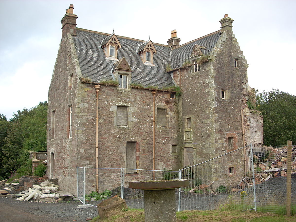
Crosbie Castle
Crosbie Castle (also known as Crosbie Towers) lies to the north east on the outskirts of West Kilbride. It was largely rebuilt from a tower demolished in the 17th century which was the home of Sir Ranald Craufurd (uncle of William Wallace) in the 13th century,[14] and it is said that Wallace himself spent some time at Crosbie.[14] Currently the castle lies at the centre of a caravan park also called Crosbie Towers. Having lain empty for a number of years due to internal fire damage, part of the building was demolished in early 2007 after heavy storms damaged the external walls of the castle.[15] Although the building is a Category-B listed building, permission was not sought before demolition.[15]
Early modern
The town became known as a weaving and agricultural town, one of many Ayrshire towns specialising in potatoes. Since the town became linked by rail to Glasgow in 1878, it began to attract more visitors, particularly to the Hydropathic spa at Seamill and its neighbouring sandy beach.
en.wikipedia.org/wiki/West_Kilbride#Crosbie_Castle
West Kilbride is generally believed to be named after the ancient Celtic Saint Brigid of Kildare, often known as St Bride.[5] The name suggests there was once a cell or kil to Brigid in the area, although local legend has her visit to establish her church around 500 AD
West Kilbride
West Kilbride9.JPG
West Kilbride from Law Hill
West Kilbride is located in North Ayrshire
West Kilbride
West Kilbride
Location within North Ayrshire
Population 4,393 [1]
OS grid reference NS205485
Council area
North Ayrshire
Lieutenancy area
Ayrshire and Arran
Country Scotland
Sovereign state United Kingdom
Post town WEST KILBRIDE
Postcode district KA23
Dialling code 01294
Police Scotland
Fire Scottish
Ambulance Scottish
UK Parliament
North Ayrshire and Arran
Scottish Parliament
Cunninghame North
List of places
UK
Scotland
55.6966°N 04.8576°WCoordinates: 55.6966°N 04.8576°W
West Kilbride (Scottish Gaelic: Cille Bhrìghde an Iar) is a village in North Ayrshire, Scotland, on the west coast by the Firth of Clyde, looking across the Firth of Clyde to Goat Fell and the Isle of Arran. West Kilbride and adjoining districts of Seamill and Portencross are generally considered to be a small town, having a combined population of 4,393 at the 2001 census.[1]
Contents
1 History
1.1 Early history
1.2 Celtic
1.3 Medieval
1.4 Early modern
2 Governance
3 Geography
4 Demography
5 Economy
5.1 Work and employment
5.2 Farming and local industry
5.3 Crafts
6 Culture
6.1 Festivals and public events
6.1.1 Yuletide Night
6.1.2 Scarecrow Festival
6.2 Sport
7 Landmarks
8 Education
9 Transport
9.1 Rail
9.2 Bus
9.3 Road
10 Notable residents
11 In the news and popular culture
12 See also
13 Notes
14 References
15 External links
History
West Kilbride's Scottish Sundial
Early history
A Neolithic cup and ring marked stone is located on Blackshaw Hill, near West Kilbride. This stone is unusual, in that it is carved with three spirals.[2] Although the purpose of such stones is not known, it is considered that they may have had religious importance.[3]
Traces of an Iron Age fortification were uncovered when the house named "The Fort" was constructed in Ardrossan Road, Seamill.[4]
Celtic
West Kilbride is generally believed to be named after the ancient Celtic Saint Brigid of Kildare, often known as St Bride.[5] The name suggests there was once a cell or kil to Brigid in the area, although local legend has her visit to establish her church around 500 AD (the landing point was supposedly in front of the now Seamill Hydro). The "West" prefix was added to distinguish between other places which commemorates the same Celtic saint, such as the new town East Kilbride in Lanarkshire which was named "East" to distinguish it from the older "West".[6] There has been a hamlet in the area since 82 AD when the Roman general Agricola stationed 30,000 troops in the area of the village now known as Gateside. Roman roads can still be explored around the village to this day, and many Roman finds have been reported and lodged in Museums throughout Scotland. William Wallace's uncle Crauford had an estate at Corsbie in the North of the village, and this is still in use as a caravan park called Crosby, to this day (Wallace's mother's family). In later years Robert the Bruce gave a grant of the lands of the Barony of Kilbride to the Boyds of Kilmarnock.[7] It was once home to various mills and other works,[8] and in the 18th century West Kilbride was primarily a weaving village.
In 1826, the Hunterston Brooch, a highly important Celtic brooch of "pseudo-penannular" type was found by two men from West Kilbride who were digging drains at the foot of Goldenberry Hill, near Hunterston.[9] Made about 700 AD,[10] the Hunterston Brooch is cast in silver, gilt, and gold, silver and amber, and decorated with interlaced animal bodies in gold filigree.[10] In its centre, a cross and a golden Glory represent the Risen Christ. The Hunterston Brooch is clearly object of very high status, indicating the power and great prestige of its owner. Nowadays, it is considered one of the most significant items of Celtic art, and is housed in the Royal Museum of Scotland, Edinburgh.[10]
Medieval
upload.wikimedia.org/wikipedia/commons/0/0b/Law_Castle.jpg
Law Castle
Several buildings in the area date back to medieval times. Law Castle, situated at the foot of Law Hill, was built in the 15th century for King James III's sister Mary.[11] The castle is a simple rectangular structure with a sloping roof and several large chimneys protruding at each side. In recent years, Law Castle has been substantially restored and refurbished and it now letted for functions and as a holiday home.[11]
Portencross Castle, thought to date from the 14th century,[12] is situated right next to the sea at Portencross harbour. It is L-shaped and four storeys high, with a barrel-vaulted ceiling.[12] The castle was roofless for many years due to storm damage. A campaign to save Portencross Castle from private ownership received national publicity in July 2004 when it was featured on the BBC's Restoration television programme.[13] The title for the castle and grounds was given to the group "Friends of Portencross Castle" on 22 December 2005.[12] It has since been partly restored and visitors have been allowed since summer 2011. www.portencrosscastle.org.uk/index.htm It is thought that a previous incarnation of the castle was a staging post on the route for the transport of dead Scottish Kings to the Island of Iona for burial.[citation needed]
Crosbie Castle
Crosbie Castle (also known as Crosbie Towers) lies to the north east on the outskirts of West Kilbride. It was largely rebuilt from a tower demolished in the 17th century which was the home of Sir Ranald Craufurd (uncle of William Wallace) in the 13th century,[14] and it is said that Wallace himself spent some time at Crosbie.[14] Currently the castle lies at the centre of a caravan park also called Crosbie Towers. Having lain empty for a number of years due to internal fire damage, part of the building was demolished in early 2007 after heavy storms damaged the external walls of the castle.[15] Although the building is a Category-B listed building, permission was not sought before demolition.[15]
Early modern
The town became known as a weaving and agricultural town, one of many Ayrshire towns specialising in potatoes. Since the town became linked by rail to Glasgow in 1878, it began to attract more visitors, particularly to the Hydropathic spa at Seamill and its neighbouring sandy beach.